FAA INFORMATION EFFECTIVE 14 MAY 2026
Location
| FAA Identifier: | LHX |
| Lat/Long: | 38-03-00.0000N 103-30-35.1000W
38-03.000000N 103-30.585000W
38.0500000,-103.5097500
(estimated) |
| Elevation: | 4228.6 ft. / 1288.9 m (surveyed) |
| Variation: | 09E (2005) |
| From city: | 3 miles N of LA JUNTA, CO |
| Time zone: | UTC -6 (UTC -7 during Standard Time) |
| Zip code: | 81050 |
Airport Operations
| Airport use: | Open to the public |
| Activation date: | 04/1940 |
| Control tower: | no |
| ARTCC: | DENVER CENTER |
| FSS: | DENVER FLIGHT SERVICE STATION |
| NOTAMs facility: | LHX (NOTAM-D service available) |
| Attendance: | 0700-1600 |
| Wind indicator: | lighted |
| Segmented circle: | yes |
| Lights: | ACTVT REIL RWY 08 & 26; PAPI RWY 08 & 26; MIRL RWY 08/26 - CTAF. |
| Beacon: | white-green (lighted land airport)
Operates sunset to sunrise. |
Airport Communications
| CTAF/UNICOM: | 123.0 |
| WX ASOS: | 135.525 (719-384-5961) |
- APCH/DEP CTL SVC PRVDD BY DENVER ARTCC (ZDV) ON FREQS 128.375/379.95 (PUEBLO RCAG).
Nearby radio navigation aids
| VOR radial/distance | | VOR name | | Freq | | Var |
|---|
| LAAr245/39.8 | | LAMAR VOR/DME | | 116.90 | | 12E |
Airport Services
| Fuel available: | 100LL JET-A |
| Parking: | hangars and tiedowns |
| Bottled oxygen: | NONE |
Runway Information
Runway 8/26
| Dimensions: | 6849 x 75 ft. / 2088 x 23 m |
| Surface: | asphalt, in good condition |
| Weight bearing capacity: | | Single wheel: | 30.0 | | Double wheel: | 50.0 | | Double tandem: | 90.0 |
|
| Runway edge lights: | medium intensity |
| RUNWAY 8 | | RUNWAY 26 |
| Latitude: | 38-02.888358N | | 38-02.892240N |
| Longitude: | 103-31.400413W | | 103-29.973743W |
| Elevation: | 4228.6 ft. | | 4153.8 ft. |
| Traffic pattern: | left | | left |
| Runway heading: | 081 magnetic, 090 true | | 261 magnetic, 270 true |
| Markings: | nonprecision, in good condition | | nonprecision, in good condition |
| Visual slope indicator: | 2-light PAPI on left (3.00 degrees glide path) | | 2-light PAPI on left (3.00 degrees glide path) |
| Runway end identifier lights: | yes | | yes |
| Touchdown point: | yes, no lights | | yes, no lights |
| Obstructions: | 28 ft. road, 1351 ft. from runway, 8 ft. right of centerline, 41:1 slope to clear | | none |
Runway 12/30
| Dimensions: | 5803 x 60 ft. / 1769 x 18 m |
| Surface: | asphalt/concrete, in poor condition
RWY SFC RAVELING WITH FOD POTENTIAL. |
| Weight bearing capacity: | | Single wheel: | 50.0 | | Double wheel: | 65.0 | | Double tandem: | 100.0 |
|
| RUNWAY 12 | | RUNWAY 30 |
| Latitude: | 38-03.469365N | | 38-02.790673N |
| Longitude: | 103-30.891425W | | 103-30.040003W |
| Elevation: | 4185.7 ft. | | 4157.9 ft. |
| Traffic pattern: | left | | left |
| Runway heading: | 126 magnetic, 135 true | | 306 magnetic, 315 true |
| Markings: | basic, in fair condition | | basic, in fair condition |
| Touchdown point: | yes, no lights | | yes, no lights |
Helipad H1
| Dimensions: | 145 x 145 ft. / 44 x 44 m |
| Surface: | asphalt, in fair condition |
| Latitude: | 38-02.773167N | | |
| Longitude: | 103-30.848667W | | |
| Elevation: | 4197.0 ft. | | |
| Traffic pattern: | left | | left |
| Markings: | basic, in poor condition | | |
Airport Ownership and Management from official FAA records
| Ownership: | Publicly-owned |
| Owner: | CITY OF LA JUNTA
PO BOX 489
LA JUNTA, CO 81050
Phone 719-384-8407 |
| Manager: | BROCK HINKHOUSE
P O BOX 489
LA JUNTA, CO 81050
Phone 719-363-1253
ALT CTC FBO 719-384-8407. |
Additional Remarks
| - | ANTELOPE ON & INVOF ARPT. |
| - | HVY AGRICULTURAL OPNS DURG SUMMER MONTHS. |
| - | RWY 12/30 HAS LOOSE ASPH MTRL IN PRIM SFC WEST SIDE OF RWY FULL LENGTH. |
| - | RWY 12/30 EDGE UNDEFINED. |
| - | BE ALERT; INTENSIVE USAF STUDENT TRNG INVOF COLORADO SPRINGS & PUEBLO COLORADO. |
| - | SELF SERVE JET-A NOT AVAIL. |
| - | FOR CD CTC DENVER ARTCC AT 303-651-4257. |
Instrument Procedures
NOTE: All procedures below are presented as PDF files. If you need a reader for these files, you should download the free Adobe Reader.NOT FOR NAVIGATION. Please procure official charts for flight.
FAA instrument procedures published for use from 14 May 2026 at 0901Z to 11 June 2026 at 0900Z.
IAPs - Instrument Approach Procedures |
|---|
| RNAV (GPS) RWY 08 | |
download (242KB) |
| RNAV (GPS) RWY 26 | |
download (228KB) |
| NOTE: Special Alternate Minimums apply | |
download (24KB) |
| NOTE: Special Take-Off Minimums/Departure Procedures apply | |
download (141KB) |
Other nearby airports with instrument procedures:
KLAA - Southeast Colorado Regional Airport (39 nm E)
KPUB - Pueblo Memorial Airport (49 nm W)
8V7 - Springfield Municipal Airport (55 nm SE)
KTAD - Perry Stokes Airport (62 nm SW)
4V1 - Spanish Peaks Airfield (64 nm W)
|
|

Road maps at:
MapQuest
Bing
Google
| Aerial photo |
|---|
WARNING: Photo may not be current or correct
 Photo taken 21-May-2006
Do you have a better or more recent aerial photo of La Junta Municipal Airport that you would like to share? If so, please send us your photo.
|
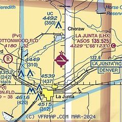
| Sectional chart |
|---|
|
CAUTION: Diagram may not be current

| Airport distance calculator |
|---|
|
|
| Sunrise and sunset |
|---|
|
Times for 26-May-2026
| | Local
(UTC-6) | | Zulu
(UTC) |
|---|
| Morning civil twilight | | 05:06 | | 11:06 |
| Sunrise | | 05:37 | | 11:37 |
| Sunset | | 20:05 | | 02:05 |
| Evening civil twilight | | 20:36 | | 02:36 |
|
| Current date and time |
|---|
| Zulu (UTC) | 26-May-2026 22:11:22 |
|---|
| Local (UTC-6) | 26-May-2026 16:11:22 |
|---|
|
| METAR |
|---|
| KLHX | 262153Z AUTO 14018G25KT 10SM SCT080 SCT095 27/07 A2983 RMK AO2 PK WND 15032/2113 SLP048 T02720072 $
|
|
| TAF |
|---|
KPUB
49nm W | 261720Z 2618/2718 10006KT P6SM BKN060 BKN200 FM262000 15012G22KT P6SM BKN050 BKN220 PROB30 2621/2703 -TSRA OVC050CB FM270300 14010KT P6SM OVC050 FM270800 VRB06KT P6SM SCT020 OVC060 PROB30 2708/2714 -SHRA SCT020 OVC060
|
|
| NOTAMs |
|---|
NOTAMs are issued by the DoD/FAA and will open in a separate window not controlled by AirNav.
|
|


