FAA INFORMATION EFFECTIVE 27 NOVEMBER 2025
Location
| FAA Identifier: | MTH |
| Lat/Long: | 24-43-34.3000N 081-03-04.9000W
24-43.571667N 081-03.081667W
24.7261944,-81.0513611
(estimated) |
| Elevation: | 5.2 ft. / 1.6 m (surveyed) |
| Variation: | 04W (2000) |
| From city: | 3 miles E of MARATHON, FL |
| Time zone: | UTC -5 (UTC -4 during Daylight Saving Time) |
| Zip code: | 33050 |
Airport Operations
| Airport use: | Open to the public |
| Activation date: | 03/1944 |
| Control tower: | no |
| ARTCC: | MIAMI CENTER |
| FSS: | MIAMI FLIGHT SERVICE STATION |
| NOTAMs facility: | MTH (NOTAM-D service available) |
| Attendance: | 0800-1800 |
| Wind indicator: | lighted |
| Segmented circle: | yes |
| Lights: | ACTVT REIL RWY 07; PAPI RWY 07 & 25; MIRL RWY 07/25 - CTAF. |
| Beacon: | white-green (lighted land airport)
Operates sunset to sunrise. |
| Fire and rescue: | ARFF index A |
| Airline operations: | 48 HR PPR FOR UNSKED PART 121 OPS WITH GTR THAN 30 PAX SEATS. |
| International operations: | US CUSTOMS USER FEE ARPT. |
Airport Communications
| CTAF/UNICOM: | 122.975 |
| WX ASOS: | 135.525 (305-743-8373) |
- APCH/DEP SVC PRVDD BY MIAMI ARTCC ON FREQS 133.5/306.9 (KEY WEST RCAG).
- AIRCRAFT OVERFLYING SIMPL, ACRUZ, CANOA AND MAXIM SHALL CONTACT MIAMI ARTCC 10 MINUTES PRIOR TO CROSSING THE MIAMI FIR ON 132.2 / 323.1.
Airport Services
| Fuel available: | 100LL JET-A1+
A1+:AFT HR JET-A FUEL - 305-481-7615. |
| Parking: | tiedowns |
| Airframe service: | MINOR |
| Powerplant service: | MINOR |
| Bottled oxygen: | HIGH/LOW |
| Bulk oxygen: | HIGH/LOW |
Runway Information
Runway 7/25
| Dimensions: | 5008 x 100 ft. / 1526 x 30 m |
| Surface: | asphalt/grooved, in fair condition |
| Weight bearing capacity: | | Single wheel: | 62.0 | | Double wheel: | 100.0 | | Double tandem: | 182.0 |
|
| Runway edge lights: | medium intensity |
| RUNWAY 7 | | RUNWAY 25 |
| Latitude: | 24-43.411320N | | 24-43.730610N |
| Longitude: | 081-03.499618W | | 081-02.664533W |
| Elevation: | 4.6 ft. | | 5.2 ft. |
| Traffic pattern: | left | | left |
| Runway heading: | 071 magnetic, 067 true | | 251 magnetic, 247 true |
| Declared distances: | TORA:5008 TODA:5008 ASDA:5008 LDA:5008 | | TORA:5008 TODA:5008 ASDA:5008 LDA:5008 |
| Markings: | nonprecision, in good condition | | nonprecision, in good condition |
| Visual slope indicator: | 4-light PAPI on left (3.00 degrees glide path) | | 4-light PAPI on left (3.00 degrees glide path) |
| Runway end identifier lights: | yes | | |
| Touchdown point: | yes, no lights | | yes, no lights |
| Obstructions: | 40 ft. tree, 1700 ft. from runway, 80 ft. left of centerline, 37:1 slope to clear | | 65 ft. tree, 2440 ft. from runway, 150 ft. right of centerline, 34:1 slope to clear |
Airport Ownership and Management from official FAA records
| Ownership: | Publicly-owned |
| Owner: | MONROE COUNTY
500 WHITEHEAD ST
KEY WEST, FL 33040
Phone 305-296-5439 |
| Manager: | MICHAEL LEGERE
9400 OVERSEAS HWY SUITE 200
MARATHON, FL 33050
Phone 305-289-6302 |
Additional Remarks
| A39-07/25 | PCR VALUE: 200/F/A/X/T |
| - | FOR CD IF UNA TO CTC ON FSS FREQ, CTC MIAMI ARTCC AT 305-716-1731. |
| - | SELF SVC FUEL H24. |
| - | USCBP USER FEE FAC OPEN THUR-MON 0900-1730. CLSD TO ARRS TUE AND WED EXCEPT ON REQ AND APVL BY USCBP. CTC USCBP AT 305-289-2029. SEE SPL NOTICES - U.S. SPL CUST REQUIREMENT. |
| - | TWY A RESTRICTIONS MAY APPLY TO ACFT WITH A WINGSPAN OF 79 FT OR GREATER WHEN ACFT ARE LDG OR TAKING OFF ON RWY 07-25. ARPT OPR NOTIFICATION WILL BE TRANSMITTED ON CTAF 122.975. |
| - | NOISE SENS AREA; USE NBAA NOISE ABATEMENT PROC; LCL ORDINANCE RQR ENG RUNUP IN DSGND AREA ON COML OR FBO RAMP FM 2300-0700 & FINES. |
| - | BIRDS ON & INVOF ARPT. |
Instrument Procedures
NOTE: All procedures below are presented as PDF files. If you need a reader for these files, you should download the free Adobe Reader.NOT FOR NAVIGATION. Please procure official charts for flight.
FAA instrument procedures published for use from 27 November 2025 at 0901Z to 25 December 2025 at 0900Z.
IAPs - Instrument Approach Procedures |
|---|
| RNAV (GPS) RWY 07 | |
download (233KB) |
| RNAV (GPS) RWY 25 | |
download (215KB) |
| NOTE: Special Alternate Minimums apply | |
download (148KB) |
| NOTE: Special Take-Off Minimums/Departure Procedures apply | |
download (412KB) |
Other nearby airports with instrument procedures:
KNQX - Key West Naval Air Station (Boca Chica Field) Airport (36 nm W)
KEYW - Key West International Airport (40 nm W)
X51 - Miami Homestead General Aviation Airport (54 nm NE)
07FA - Ocean Reef Club Airport (55 nm NE)
KHST - Homestead Air Reserve Base (58 nm NE)
|
|

Road maps at:
MapQuest
Bing
Google
| Aerial photo |
|---|
WARNING: Photo may not be current or correct
 Photo by Dave Fogarty ATP/CFI/A&P-IA
Photo taken 27-Jan-2020
looking east.
Photo by Dave Fogarty ATP/CFI/A&P-IA
Photo taken 27-Jan-2020
looking east.
Do you have a better or more recent aerial photo of The Florida Keys Marathon International Airport that you would like to share? If so, please send us your photo.
|
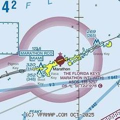
| Sectional chart |
|---|
|
CAUTION: Diagram may not be current

| Airport distance calculator |
|---|
|
|
| Sunrise and sunset |
|---|
|
Times for 03-Dec-2025
| | Local
(UTC-5) | | Zulu
(UTC) |
|---|
| Morning civil twilight | | 06:29 | | 11:29 |
| Sunrise | | 06:54 | | 11:54 |
| Sunset | | 17:34 | | 22:34 |
| Evening civil twilight | | 17:59 | | 22:59 |
|
| Current date and time |
|---|
| Zulu (UTC) | 03-Dec-2025 06:50:40 |
|---|
| Local (UTC-5) | 03-Dec-2025 01:50:40 |
|---|
|
| METAR |
|---|
| KMTH | 030553Z AUTO 00000KT 10SM CLR A2997 RMK AO2 SLP150 60000 58006 $
|
|
| TAF |
|---|
| KMTH | 030540Z 0306/0406 30003KT P6SM FEW015 SCT022 FM031000 01003KT 1/2SM FG BKN005 FM031500 01006KT P6SM SCT025
|
|
| NOTAMs |
|---|
NOTAMs are issued by the DoD/FAA and will open in a separate window not controlled by AirNav.
|
|


