FAA INFORMATION EFFECTIVE 14 MAY 2026
Location
| FAA Identifier: | RBE |
| Lat/Long: | 42-34-16.0528N 099-34-10.2727W
42-34.267547N 099-34.171212W
42.5711258,-99.5695202
(estimated) |
| Elevation: | 2349.4 ft. / 716.1 m (surveyed) |
| Variation: | 08E (1990) |
| From city: | 2 miles SW of BASSETT, NE |
| Time zone: | UTC -5 (UTC -6 during Standard Time) |
| Zip code: | 68714 |
Airport Operations
| Airport use: | Open to the public |
| Activation date: | 08/1950 |
| Control tower: | no |
| ARTCC: | DENVER CENTER |
| FSS: | COLUMBUS FLIGHT SERVICE STATION |
| NOTAMs facility: | OLU (NOTAM-D service available) |
| Attendance: | UNATNDD |
| Wind indicator: | lighted |
| Segmented circle: | yes |
| Lights: | ACTVT MIRL RY 13/31 & PAPI RYS 13 & 31 - CTAF. |
| Beacon: | white-green (lighted land airport)
Operates sunset to sunrise. |
| Taxiway lights: | TURNOFF LGTS ONLY. |
Airport Communications
| CTAF: | 122.9 |
| WX AWOS-3 at ANW (19 nm W): | 118.325 (402-387-2329) |
- APCH/DEP CTL SVC PRVDD BY DENVER ARTCC (ZDV) ON FREQS 127.95/338.2 (AINSWORTH RCAG).
Nearby radio navigation aids
| VOR radial/distance | | VOR name | | Freq | | Var |
|---|
| ANWr081/18.6 | | AINSWORTH VOR/DME | | 112.70 | | 09E |
| ONLr269/39.5 | | O'NEILL VORTAC | | 113.90 | | 10E |
Airport Services
| Fuel available: | 100LL
100LL:24 HR CREDIT CARD |
| Parking: | hangars and tiedowns |
| Airframe service: | NONE |
| Powerplant service: | NONE |
| Bottled oxygen: | NONE |
| Bulk oxygen: | NONE |
Runway Information
Runway 13/31
| Dimensions: | 4698 x 75 ft. / 1432 x 23 m |
| Surface: | concrete, in good condition |
| Weight bearing capacity: | |
| Runway edge lights: | medium intensity |
| RUNWAY 13 | | RUNWAY 31 |
| Latitude: | 42-34.479310N | | 42-33.879862N |
| Longitude: | 099-34.432688W | | 099-33.771422W |
| Elevation: | 2344.4 ft. | | 2349.4 ft. |
| Traffic pattern: | left | | left |
| Runway heading: | 133 magnetic, 141 true | | 313 magnetic, 321 true |
| Markings: | nonprecision, in good condition | | nonprecision, in good condition |
| Visual slope indicator: | 2-light PAPI on left (3.00 degrees glide path) | | 2-light PAPI on left (3.00 degrees glide path) |
| Touchdown point: | yes, no lights | | yes, no lights |
| Obstructions: | none
RWY 31 CLNC SLOPE ON CTRLN 50:1. | | 4 ft. fence, 200 ft. from runway, 250 ft. left of centerline |
Runway 2/20
| Dimensions: | 2202 x 120 ft. / 671 x 37 m |
| Surface: | turf, in fair condition |
| RUNWAY 2 | | RUNWAY 20 |
| Latitude: | 42-34.307198N | | 42-34.603227N |
| Longitude: | 099-34.460340W | | 099-34.177178W |
| Elevation: | 2343.9 ft. | | 2341.9 ft. |
| Traffic pattern: | left | | left |
| Runway heading: | 027 magnetic, 035 true | | 207 magnetic, 215 true |
| Touchdown point: | yes, no lights | | yes, no lights |
Airport Ownership and Management from official FAA records
| Ownership: | Publicly-owned |
| Owner: | ROCK COUNTY AIRPORT AUTHORITY
PO BOX 7, PO BOX 385
BASSETT, NE 68714-0007
Phone 402-684-3436 |
| Manager: | BERNIE HART
504 S. STATE STREET
BASSETT, NE 68714-5046
Phone 402-684-2254 |
Additional Remarks
| - | DEER ON & INVOF ARPT. |
| - | FOR CD CTC DENVER ARTCC AT 303-651-4257. |
Instrument Procedures
NOTE: All procedures below are presented as PDF files. If you need a reader for these files, you should download the free Adobe Reader.NOT FOR NAVIGATION. Please procure official charts for flight.
FAA instrument procedures published for use from 14 May 2026 at 0901Z to 11 June 2026 at 0900Z.
IAPs - Instrument Approach Procedures |
|---|
| RNAV (GPS) RWY 13 **CHANGED** | |
download (256KB) |
| RNAV (GPS) RWY 31 **CHANGED** | |
download (202KB) |
| NOTE: Special Take-Off Minimums/Departure Procedures apply | |
download (147KB) |
Other nearby airports with instrument procedures:
KANW - Ainsworth Regional Airport (19 nm W)
8V2 - Stuart-Atkinson Municipal Airport (23 nm E)
KONL - The O'Neill Municipal Airport-John L Baker Field (39 nm E)
9D1 - Gregory Municipal Airport/Flynn Field (40 nm N)
KVTN - Miller Field Airport (46 nm W)
|
|

Road maps at:
MapQuest
Bing
Google
| Aerial photo |
|---|
WARNING: Photo may not be current or correct
 Photo by Travis Ammon
Photo taken 27-Apr-2010
looking north.
Photo by Travis Ammon
Photo taken 27-Apr-2010
looking north.
Do you have a better or more recent aerial photo of Rock County Airport that you would like to share? If so, please send us your photo.
|
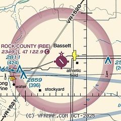
| Sectional chart |
|---|
|
| Airport distance calculator |
|---|
|
|
| Sunrise and sunset |
|---|
|
Times for 16-May-2026
| | Local
(UTC-5) | | Zulu
(UTC) |
|---|
| Morning civil twilight | | 05:44 | | 10:44 |
| Sunrise | | 06:16 | | 11:16 |
| Sunset | | 20:53 | | 01:53 |
| Evening civil twilight | | 21:26 | | 02:26 |
|
| Current date and time |
|---|
| Zulu (UTC) | 17-May-2026 04:11:19 |
|---|
| Local (UTC-5) | 16-May-2026 23:11:19 |
|---|
|
| METAR |
|---|
KANW
19nm W | 170355Z AUTO 14007KT 10SM BKN120 20/02 A2970 RMK AO2 T01950024
|
|
| TAF |
|---|
KVTN
47nm NW | 161732Z 1618/1718 11014KT P6SM SCT120 BKN200 FM170200 10012G19KT P6SM -TSRA BKN080CB FM170500 10010G15KT P6SM -SHRA BKN080 FM171000 12007KT P6SM BKN008 FM171300 VRB04KT 4SM BR BKN005 FM171700 27008KT P6SM BKN014
|
|
| NOTAMs |
|---|
NOTAMs are issued by the DoD/FAA and will open in a separate window not controlled by AirNav.
|
|

