FAA INFORMATION EFFECTIVE 30 OCTOBER 2025
Location
| FAA Identifier: | RNO |
| Lat/Long: | 39-29-56.8000N 119-46-05.2000W
39-29.946667N 119-46.086667W
39.4991111,-119.7681111
(estimated) |
| Elevation: | 4414.9 ft. / 1345.7 m (surveyed) |
| Variation: | 13E (2020) |
| From city: | 3 miles SE of RENO, NV |
| Time zone: | UTC -8 (UTC -7 during Daylight Saving Time) |
| Zip code: | 89502 |
Airport Operations
| Airport use: | Open to the public |
| Activation date: | 11/1938 |
| Control tower: | yes |
| ARTCC: | OAKLAND CENTER |
| FSS: | RENO FLIGHT SERVICE STATION |
| NOTAMs facility: | RNO (NOTAM-D service available) |
| Attendance: | CONTINUOUS |
| Pattern altitude: | 5214.9 ft. MSL
800 FT AGL SNGL ENG; 1000 FT AGL MULT ENG/TURBOPROP/JET. |
| Wind indicator: | lighted |
| Segmented circle: | no |
| Lights: | SS-SR |
| Beacon: | white-green (lighted land airport)
Operates sunset to sunrise. |
| Fire and rescue: | ARFF index C |
| International operations: | customs landing rights airport
LDG RIGHTS ARPT, PPR - CALL (775) 784-5585; AFT HRS
LDG WO PRIOR APVL NA. |
Airport Communications
| UNICOM: | 122.95 |
| WX ASOS: | 135.8 (775-432-6755) |
| RENO GROUND: | 121.9 348.6 |
| RENO TOWER: | 118.7 257.8 |
| NORCAL APPROACH: | 119.2 ;036-225 FMG 126.3 ;226-035 FMG |
| NORCAL DEPARTURE: | 119.2 ;036-225 FMG 126.3 ;226-035 FMG |
| CLEARANCE DELIVERY: | 124.9 370.85 |
| ALPYN DP: | 119.2 |
| ANAHO STAR: | 126.3 ;RWY 16L/R, RWY 34L/R |
| ANG COMD POST: | 378.4 ;CALLSIGN-ROLLER OPS. 8780 ;CALLSIGN-ROLLER OPS. |
| ANG OPS: | 280.0 378.4 ;CALLSIGN-ROLLER OPS. 8780 ;CALLSIGN-ROLLER OPS. |
| CLASS C: | 119.2 ;036-225 FMG 126.3 ;226-035 FMG |
| D-ATIS: | 135.8 363.0 |
| EELZA STAR: | 126.3 ;RWY 34L/R |
| EMERG: | 121.5 243.0 |
| KLUBS STAR: | 126.3 |
| MUSTANG DP: | 119.2 ;RWY 16L/R |
| MYBAD STAR: | 126.3 ;RWY 16L/R |
| ORRCA STAR: | 126.3 |
| PVINE DP: | 126.3 ;RWY 34L/R |
| RENO DP: | 119.2 ;RWY 16L/R 126.3 ;RWY 25, RWY 34L/R |
| RYANN STAR: | 119.2 ;RWY 16 ONLY |
| SCOLA STAR: | 119.2 |
| SPARKS DP: | 119.2 ;RWY 17L/R 126.3 ;RWY 26, RWY 35L/R |
| TARVR STAR: | 119.2 ;RWY 34L/R |
| WADOL STAR: | 126.3 ;RWY 34L/R |
| WAGGE DP: | 119.2 ;RWY 16L/R |
| WINRZ STAR: | 126.3 |
| ZEFFR DP: | 119.2 ;RWY 16L/R |
| WX AWOS-3 at RTS (11 nm NW): | 135.175 (775-677-0589) |
| WX AWOS-3PT at CXP (18 nm S): | 119.925 (775-884-4708) |
Nearby radio navigation aids
| VOR radial/distance | | VOR name | | Freq | | Var |
|---|
| FMGr234/5.5 | | MUSTANG VORTAC | | 117.90 | | 16E |
| SWRr035/30.1 | | PALISADES VOR/DME | | 113.20 | | 16E |
| HZNr251/35.7 | | HAZEN VORTAC | | 114.10 | | 17E |
Airport Services
| Fuel available: | 100LL JET-A1+ |
| Parking: | tiedowns |
| Airframe service: | MAJOR |
| Powerplant service: | MAJOR |
| Bottled oxygen: | HIGH/LOW |
| Bulk oxygen: | HIGH/LOW |
Runway Information
Runway 17R/35L
| Dimensions: | 11001 x 150 ft. / 3353 x 46 m |
| Surface: | concrete/grooved, in good condition |
| Weight bearing capacity: | | Single wheel: | 75.0 | | Double wheel: | 185.0 | | Double tandem: | 350.0 | | Dual double tandem: | 850.0 |
|
| Runway edge lights: | high intensity |
| RUNWAY 17R | | RUNWAY 35L |
| Latitude: | 39-30.830635N | | 39-29.018895N |
| Longitude: | 119-46.153228W | | 119-46.157917W |
| Elevation: | 4414.8 ft. | | 4414.5 ft. |
| Traffic pattern: | left | | left |
| Runway heading: | 167 magnetic, 180 true | | 347 magnetic, 000 true |
| Displaced threshold: | 1000 ft. | | 990 ft. |
| Declared distances: | TORA:11001 TODA:11001 ASDA:11001 LDA:10001 | | TORA:11001 TODA:11001 ASDA:11001 LDA:10011 |
| Markings: | precision, in good condition | | precision, in good condition |
| Visual slope indicator: | 4-light PAPI on left (3.06 degrees glide path) | | 4-light PAPI on left (3.54 degrees glide path) |
| RVR equipment: | touchdown | | rollout |
| Approach lights: | MALSR: 1,400 foot medium intensity approach lighting system with runway alignment indicator lights | | MALSR: 1,400 foot medium intensity approach lighting system with runway alignment indicator lights |
| Runway end identifier lights: | no | | no |
| Centerline lights: | yes | | yes |
| Touchdown point: | yes, no lights | | yes, no lights |
| Instrument approach: | ILS/DME | | ILS/DME |
| Obstructions: | none | | 243 ft. gnd, 8050 ft. from runway, 1500 ft. right of centerline, 32:1 slope to clear
APCH RATIO 37:1 TO DTHR. |
Runway 17L/35R
| Dimensions: | 9000 x 150 ft. / 2743 x 46 m |
| Surface: | concrete/grooved, in good condition |
| Weight bearing capacity: | | Single wheel: | 75.0 | | Double wheel: | 209.0 | | Double tandem: | 407.0 | | Dual double tandem: | 850.0 |
|
| Runway edge lights: | high intensity |
| RUNWAY 17L | | RUNWAY 35R |
| Latitude: | 39-30.830430N | | 39-29.348248N |
| Longitude: | 119-46.004433W | | 119-46.008285W |
| Elevation: | 4414.8 ft. | | 4408.3 ft. |
| Traffic pattern: | left | | left |
| Runway heading: | 167 magnetic, 180 true | | 347 magnetic, 000 true |
| Declared distances: | TORA:9000 TODA:9000 ASDA:9000 LDA:9000 | | TORA:9000 TODA:9000 ASDA:9000 LDA:9000 |
| Markings: | nonprecision, in good condition | | nonprecision, in good condition |
| Visual slope indicator: | 4-light PAPI on left (3.00 degrees glide path) | | 4-light PAPI on left (3.35 degrees glide path) |
| Runway end identifier lights: | yes | | yes |
| Centerline lights: | yes | | yes |
| Touchdown point: | yes, no lights | | yes, no lights |
Runway 8/26
| Dimensions: | 6102 x 150 ft. / 1860 x 46 m |
| Surface: | concrete/grooved, in good condition |
| Weight bearing capacity: | | Single wheel: | 60.0 | | Double wheel: | 170.0 | | Double tandem: | 260.0 |
|
| Runway edge lights: | medium intensity |
| RUNWAY 8 | | RUNWAY 26 |
| Latitude: | 39-29.777165N | | 39-29.772898N |
| Longitude: | 119-46.730367W | | 119-45.433297W |
| Elevation: | 4409.2 ft. | | 4399.6 ft. |
| Traffic pattern: | left | | left |
| Runway heading: | 077 magnetic, 090 true | | 257 magnetic, 270 true |
| Declared distances: | TORA:5854 TODA:5854 ASDA:6102 LDA:5854 | | TORA:6102 TODA:6102 ASDA:6102 LDA:6102 |
| Markings: | nonprecision, in good condition | | nonprecision, in good condition |
| Visual slope indicator: | 4-light PAPI on left (3.20 degrees glide path) | | 4-light PAPI on left (3.00 degrees glide path) |
| Runway end identifier lights: | yes | | yes |
| Touchdown point: | yes, no lights | | yes, no lights |
| Obstructions: | 118 ft. pole, 2625 ft. from runway, 500 ft. left of centerline, 20:1 slope to clear | | 44 ft. tree, 1150 ft. from runway, 275 ft. left of centerline, 21:1 slope to clear |
Airport Ownership and Management from official FAA records
| Ownership: | Publicly-owned |
| Owner: | RENO-TAHOE AIRPORT AUTHORITY
P O BOX 12490
RENO, NV 89510-2490
Phone 775-328-6600 |
| Manager: | DAREN GRIFFIN, A.A.E.
P O BOX 12490
RENO, NV 89510-2490
Phone 775-328-6600 |
Additional Remarks
| A39-17L/35R | PCR VALUE: 1034/R/C/W/T |
| A39-17R/35L | PCR VALUE: 917/R/B/W/T |
| A39-08/26 | PCR VALUE: 787/R/C/W/T |
| - | WATERFOWL ALL QUADRANTS ALL SEASONS. CONCENTRATED NW OF RWY 17R AND EAST OF RWY 17L. |
| - | GLIDER/SOARING OPER 30-50 MILES SOUTH OF ARPT DURING VFR WEATHER & MOUNTAIN WAVE WIND CONDITIONS 1100 TO SS. |
| - | TWY C BTN TWY L AND TWY D CLSD TO AIR CARRIER ACFT. |
| - | TWY A BETWEEN NORTH TWY B AND TWY D CLSD TO ACFT WITH WINGSPAN GREATER THAN 149 FT. |
| - | ALL COMMERCIAL AIRCRAFT CONTACT GROUND CONTROL FOR ADVISORIES PRIOR TO PUSH BACK ON THE TERMINAL RAMP. |
| - | INTENSIVE GLIDER ACTIVITY INVOF ARPT AND SURROUNDING AREAS UP TO 18000 FT. |
| - | 24 HRS PPR FOR TSNT ACFT PRKG WITH WINGSPANS GTR THAN 75 FT CALL 775-328-6600. |
| - | ANG: PPR 24 HR PN RQRD. |
| - | TWY M CLSD TO AIR CARRIER ACFT. |
| - | TWY J EAST OF RWY 17L/35R CLSD TO AIR CARRIER ACFT. |
| - | ANG: ANG OPS 1430-2359Z++ MON-FRI EXC HOL AND SKED DAYS OFF; OTR TIMES BY NOTAM; DSN 830-4709 OR C775-788-4709. |
| - | ANG: APN HAS 22 FT X 6 FT ACFT GND EQUIP (AGE) BOXES LCTD TO THE EAST OF EA PKG SPOT. |
| - | ACFT OVR 12500 LBS: WRITTEN PPR FOR TRG FLTS; FOR FTHR INFO CTC ARPT OPS 1-775-328-6600. |
| - | ANG: COMSEC MTRL STORAGE AVBL WITH PRIOR CDN AT 152 CF/SCXS, DSN 830-4798. |
| - | COLD TEMPERATURE AIRPORT. ALTITUDE CORRECTION REQUIRED AT OR BELOW -13C. |
| - | TWY C BTN TWY L & TWY D RSTRD TO ACFT 100000 LBS OR LESS. |
| - | NOISE SENSITIVE AREA ALL QUADS. PILOTS OF TBJT ACFT USE RCMDD NOISE ABATEMENT PROCS; AVBL ON REQ. |
| - | NOISE NOTE CONT: PILOTS OF NON-TBJT ACFT USE BEST ABATEMENT PROCS AND SETTINGS. AVOID AS MUCH AS FEASIBLE FLYING OVER POPULATED AREAS. |
| - | MIL ACFT: TSNT ACFT EXECUTE STRAIGHT-IN FULL STOP APCH. OVERHEAD PAT NOT AUTH FOR TSNT ACFT. |
| - | MIL ACFT: NOISE ABTMT CRITICAL TERMINATE AFTERBURNER ASAP THEN CLIMB TO 6500 FT MSL ASAP. |
Instrument Procedures
NOTE: All procedures below are presented as PDF files. If you need a reader for these files, you should download the free Adobe Reader.NOT FOR NAVIGATION. Please procure official charts for flight.
FAA instrument procedures published for use from 30 October 2025 at 0901Z to 27 November 2025 at 0900Z.
STARs - Standard Terminal Arrivals |
|---|
| ANAHO TWO | |
download (134KB) |
| EELZA FOUR (RNAV) | |
download (158KB) |
| KLUBS ONE (RNAV) | |
download (157KB) |
| ORRCA ONE (RNAV) | |
download (115KB) |
| RYANN TWO | |
download (112KB) |
| SCOLA ONE (RNAV) | |
download (180KB) |
| TARVR ONE (RNAV) | |
download (165KB) |
| WADOL FOUR (RNAV) | |
download (142KB) |
| WINRZ ONE (RNAV) **CHANGED** | |
download (166KB) |
IAPs - Instrument Approach Procedures |
|---|
| ILS OR LOC RWY 35L | |
download (548KB) |
| ILS X OR LOC X RWY 17R | |
download (461KB) |
| ILS Z OR LOC Z RWY 17R | |
download (507KB) |
| ILS Y RWY 17R | |
download (465KB) |
| RNAV (RNP) W RWY 35L | |
download (285KB) |
| RNAV (RNP) W RWY 35R | |
download (287KB) |
| RNAV (RNP) Y RWY 17L | |
download (482KB) |
| RNAV (RNP) Y RWY 17R | |
download (493KB) |
| RNAV (RNP) Z RWY 17L | |
download (486KB) |
| RNAV (RNP) Z RWY 17R | |
download (491KB) |
| RNAV (RNP) Z RWY 35L | |
download (468KB) |
| RNAV (RNP) Z RWY 35R | |
download (470KB) |
| RNAV (GPS) X RWY 17L | |
download (460KB) |
| RNAV (GPS) X RWY 17R | |
download (443KB) |
| RNAV (GPS) X RWY 35L | |
download (555KB) |
| RNAV (GPS) X RWY 35R | |
download (559KB) |
| RNAV (GPS) Y RWY 35L | |
download (522KB) |
| RNAV (GPS) Y RWY 35R | |
download (529KB) |
| LOC Y RWY 17R | |
download (534KB) |
| VOR-D | |
download (430KB) |
| TACAN-F | |
download (444KB) |
| NOTE: Special Alternate Minimums apply | |
download (141KB) |
Departure Procedures |
|---|
| ALPYN ONE (RNAV) | |
download (158KB) |
| MUSTANG ONE | |
download (184KB) |
| PVINE FIVE (RNAV) | |
download (181KB) |
| RENO ONE | |
download (259KB) |
| WAGGE EIGHT | |
download (192KB) |
| ZEFFR NINE (RNAV) | |
download (191KB) |
|
|---|
| SPARKS ONE (OBSTACLE) | |
2 pages:
[1] [2] (764KB) |
| SPARKS ONE (OBSTACLE), CONT.2 | |
download (319KB) |
| NOTE: Special Take-Off Minimums/Departure Procedures apply | |
download (373KB) |
Other nearby airports with instrument procedures:
KRTS - Reno/Stead Airport (11 nm NW)
KCXP - Carson City Airport (18 nm S)
KTRK - Truckee-Tahoe Airport (20 nm SW)
KSPZ - Silver Springs Airport (25 nm E)
KMEV - Minden-Tahoe Airport (30 nm S)
|
|

Road maps at:
MapQuest
Bing
Google
| Aerial photo |
|---|
WARNING: Photo may not be current or correct
 Photo courtesy of Mitch Bowers Imagewerx.us Aerial Photography
Photo taken 10-May-2012
from 10,500' looking southeast.
Photo courtesy of Mitch Bowers Imagewerx.us Aerial Photography
Photo taken 10-May-2012
from 10,500' looking southeast.
Do you have a better or more recent aerial photo of Reno/Tahoe International Airport that you would like to share? If so, please send us your photo.
|
| Sectional chart |
|---|
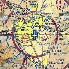
|
CAUTION: Diagram may not be current
 Download PDF
of official airport diagram from the FAA
| Airport distance calculator |
|---|
|
|
| Sunrise and sunset |
|---|
|
Times for 16-Nov-2025
| | Local
(UTC-8) | | Zulu
(UTC) |
|---|
| Morning civil twilight | | 06:17 | | 14:17 |
| Sunrise | | 06:45 | | 14:45 |
| Sunset | | 16:42 | | 00:42 |
| Evening civil twilight | | 17:11 | | 01:11 |
|
| Current date and time |
|---|
| Zulu (UTC) | 16-Nov-2025 22:21:36 |
|---|
| Local (UTC-8) | 16-Nov-2025 14:21:36 |
|---|
|
| METAR |
|---|
| KRNO | 162155Z 00000KT 10SM FEW030 OVC075 11/03 A2976 RMK AO2 SLP054 MTN TOPS OBSCD DSNT SW THRU W T01060028
|
KRTS
11nm NW | 162155Z AUTO 25016G24KT 10SM FEW039 OVC070 07/01 A2978 RMK AO2
|
KCXP
18nm S | 162155Z AUTO 22011G16KT 10SM SCT042 BKN047 BKN060 10/01 A2978 RMK AO2
|
KTRK
20nm SW | 162148Z 00000KT 5SM BKN027 OVC032 04/03 A2982
|
|
| TAF |
|---|
| KRNO | 161730Z 1618/1718 VRB06KT 5SM -SHRA SCT040 OVC060 FM162200 27009KT P6SM VCSH OVC050 FM170200 VRB06KT P6SM OVC050 FM171200 16008KT P6SM OVC100 PROB30 1713/1716 4SM -SHRA OVC050
|
KCXP
18nm S | 161730Z 1618/1718 19005KT P6SM VCSH OVC070 FM162100 22010KT 6SM BR OVC015 FM170200 19005KT P6SM OVC050 FM170700 VRB04KT P6SM OVC100 FM171200 16003KT P6SM OVC100 PROB30 1713/1716 5SM -SHRA OVC050
|
KTRK
20nm SW | 161730Z 1618/1718 21008KT 2SM -RA BR OVC020 FM162200 22010G20KT 1 1/2SM -RA FG OVC005 FM170100 20006KT P6SM VCSH OVC035 FM171000 19010G18KT 6SM -SHRA OVC030 PROB30 1712/1716 4SM -SHRASN OVC015
|
|
| NOTAMs |
|---|
NOTAMs are issued by the DoD/FAA and will open in a separate window not controlled by AirNav.
|
|


