FAA INFORMATION EFFECTIVE 19 FEBRUARY 2026
Location
| FAA Identifier: | LQR |
| Lat/Long: | 38-12-30.9747N 099-05-09.2907W
38-12.516245N 099-05.154845W
38.2086041,-99.0859141
(estimated) |
| Elevation: | 2012.1 ft. / 613.3 m (surveyed) |
| Variation: | 08E (1985) |
| From city: | 2 miles N of LARNED, KS |
| Time zone: | UTC -6 (UTC -5 during Daylight Saving Time) |
| Zip code: | 67550 |
Airport Operations
| Airport use: | Open to the public |
| Activation date: | 07/1946 |
| Control tower: | no |
| ARTCC: | KANSAS CITY CENTER |
| FSS: | WICHITA FLIGHT SERVICE STATION |
| NOTAMs facility: | ICT (NOTAM-D service available) |
| Attendance: | MON-FRI 0800-1700, ALL SAT 0800-1200 |
| Wind indicator: | lighted |
| Segmented circle: | yes |
| Lights: | ACTVT MIRL RWY 17/35; PAPI & REIL RWYS 17 & 35 - CTAF. |
| Beacon: | white-green (lighted land airport)
Operates sunset to sunrise. |
Airport Communications
| CTAF/UNICOM: | 122.8 |
| WX AWOS-3PT: | 119.875 (620-285-8552) |
| WX AWOS-3PT at GBD (13 nm NE): | 119.275 (620-792-5019) |
- APCH/DEP CTL SVC PRVDD BY KANSAS CITY ARTCC (ZKC) ON FREQS 124.4/322.4 (RUSSELL RCAG).
Nearby radio navigation aids
| VOR radial/distance | | VOR name | | Freq | | Var |
|---|
| HYSr157/39.4 | | HAYS VORTAC | | 110.40 | | 10E |
| NDB name | | Hdg/Dist | | Freq | | Var | | ID |
|---|
| BABSY | | 249/11.1 | | 419 | | 08E | | GB | --. -... |
Airport Services
| Fuel available: | 100LL
100LL:FUEL AVBL 24 HRS WITH CREDIT CARD. |
| Parking: | hangars and tiedowns |
| Airframe service: | NONE |
| Powerplant service: | NONE |
| Bottled oxygen: | NONE |
| Bulk oxygen: | NONE |
Runway Information
Runway 17/35
| Dimensions: | 4201 x 75 ft. / 1280 x 23 m |
| Surface: | concrete, in good condition |
| Weight bearing capacity: | | PCN 7 /R/C/X/U | | Single wheel: | 12.5 | | Double wheel: | 12.5 |
|
| Runway edge lights: | medium intensity |
| RUNWAY 17 | | RUNWAY 35 |
| Latitude: | 38-12.983627N | | 38-12.291473N |
| Longitude: | 099-05.106113W | | 099-05.104887W |
| Elevation: | 2010.5 ft. | | 2012.1 ft. |
| Traffic pattern: | left | | left |
| Runway heading: | 172 magnetic, 180 true | | 352 magnetic, 360 true |
| Markings: | nonprecision, in good condition | | nonprecision, in good condition |
| Visual slope indicator: | 2-light PAPI on left (3.00 degrees glide path) | | 2-light PAPI on left (3.00 degrees glide path) |
| Runway end identifier lights: | yes | | yes |
| Touchdown point: | yes, no lights | | yes, no lights |
| Obstructions: | 55 ft. trees, 1010 ft. from runway, 240 ft. left of centerline, 14:1 slope to clear | | 15 ft. road, 515 ft. from runway, 21:1 slope to clear |
Runway 4/22
| Dimensions: | 2860 x 170 ft. / 872 x 52 m |
| Surface: | turf, in good condition |
| RUNWAY 4 | | RUNWAY 22 |
| Latitude: | 38-12.263500N | | 38-12.596167N |
| Longitude: | 099-05.392000W | | 099-04.969167W |
| Elevation: | 2009.6 ft. | | 2008.0 ft. |
| Traffic pattern: | left | | left |
| Runway heading: | 037 magnetic, 045 true | | 217 magnetic, 225 true |
| Touchdown point: | yes, no lights | | yes, no lights |
Runway 12/30
| Dimensions: | 2830 x 180 ft. / 863 x 55 m |
| Surface: | turf, in good condition |
| RUNWAY 12 | | RUNWAY 30 |
| Latitude: | 38-12.589167N | | 38-12.257833N |
| Longitude: | 099-05.410000W | | 099-04.994167W |
| Elevation: | 2006.6 ft. | | 2006.4 ft. |
| Traffic pattern: | left | | left |
| Runway heading: | 127 magnetic, 135 true | | 307 magnetic, 315 true |
| Touchdown point: | yes, no lights | | yes, no lights |
Airport Ownership and Management from official FAA records
| Ownership: | Publicly-owned |
| Owner: | LARNED & PAWNEE COUNTY
BOX70
LARNED, KS 67550
Phone 620-285-8500 |
| Manager: | STEVE GROSS
RR#1 BOX 145B
LARNED, KS 67550
Phone 620-285-8580
MGR PHONE 620-285-8580 OR 620-285-5609 |
Additional Remarks
| - | INTXN RYS 04/22 & 12/30 SOFT WHEN WET. |
| - | FOR CD CTC KANSAS CITY ARTCC AT 913-254-8508. |
Instrument Procedures
NOTE: All procedures below are presented as PDF files. If you need a reader for these files, you should download the free Adobe Reader.NOT FOR NAVIGATION. Please procure official charts for flight.
FAA instrument procedures published for use from 19 February 2026 at 0901Z to 19 March 2026 at 0900Z.
IAPs - Instrument Approach Procedures |
|---|
| RNAV (GPS) RWY 17 | |
download (209KB) |
| RNAV (GPS) RWY 35 | |
download (235KB) |
| NOTE: Special Alternate Minimums apply | |
download (21KB) |
| NOTE: Special Take-Off Minimums/Departure Procedures apply | |
download (147KB) |
Other nearby airports with instrument procedures:
KGBD - Great Bend Municipal Airport (13 nm NE)
KPTT - Pratt Regional Airport (34 nm SE)
KHYS - Hays Regional Airport (39 nm N)
K79 - Jetmore Municipal Airport (40 nm W)
KLYO - Lyons-Rice County Municipal Airport (41 nm E)
|
|

Road maps at:
MapQuest
Bing
Google
| Aerial photo |
|---|
WARNING: Photo may not be current or correct

Do you have a better or more recent aerial photo of Larned-Pawnee County Airport that you would like to share? If so, please send us your photo.
|
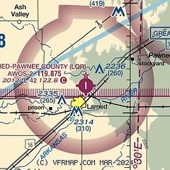
| Sectional chart |
|---|
|
| Airport distance calculator |
|---|
|
|
| Sunrise and sunset |
|---|
|
Times for 25-Feb-2026
| | Local
(UTC-6) | | Zulu
(UTC) |
|---|
| Morning civil twilight | | 06:48 | | 12:48 |
| Sunrise | | 07:15 | | 13:15 |
| Sunset | | 18:24 | | 00:24 |
| Evening civil twilight | | 18:51 | | 00:51 |
|
| Current date and time |
|---|
| Zulu (UTC) | 25-Feb-2026 21:20:24 |
|---|
| Local (UTC-6) | 25-Feb-2026 15:20:24 |
|---|
|
| METAR |
|---|
KGBD
13nm NE | 252056Z AUTO 22008G19KT 10SM CLR 22/00 A2961 RMK AO2 SLPNO T02170000 56035 $
|
|
| TAF |
|---|
KGBD
13nm NE | 251723Z 2518/2618 17007KT P6SM FEW100 FM252000 23011KT P6SM BKN100 FM260200 34015KT P6SM BKN100 FM260600 31005KT P6SM FEW100
|
|
| NOTAMs |
|---|
NOTAMs are issued by the DoD/FAA and will open in a separate window not controlled by AirNav.
|
|


