FAA INFORMATION EFFECTIVE 11 JUNE 2026
Location
| FAA Identifier: | P14 |
| Lat/Long: | 34-56-26.6000N 110-08-18.6000W
34-56.443333N 110-08.310000W
34.9407222,-110.1385000
(estimated) |
| Elevation: | 5261.8 ft. / 1603.8 m (surveyed) |
| Variation: | 12E (1995) |
| From city: | 3 miles NE of HOLBROOK, AZ |
| Time zone: | UTC -7 (year round; does not observe DST) |
| Zip code: | 86025 |
Airport Operations
| Airport use: | Open to the public |
| Activation date: | 03/1943 |
| Control tower: | no |
| ARTCC: | ALBUQUERQUE CENTER |
| FSS: | PRESCOTT FLIGHT SERVICE STATION |
| NOTAMs facility: | PRC (NOTAM-D service available) |
| Attendance: | UNATNDD
FOR SVC MON-FRI 0800-1700 - AMGR OR 928-524-3991. |
| Wind indicator: | lighted |
| Segmented circle: | no |
| Lights: | ACTVT REIL RWY 03 & 21; PAPI RWY 03 & 21; MIRL RWY 03/21 - CTAF. |
| Beacon: | white-green (lighted land airport)
Operates sunset to sunrise. |
Airport Communications
| CTAF/UNICOM: | 122.8 |
| WX AWOS-3: | 118.675 (928-524-7839) |
- COMMUNICATIONS PRVDD BY PRESCOTT RADIO ON FREQ 122.6 (WINSLOW RCO).
Nearby radio navigation aids
| VOR radial/distance | | VOR name | | Freq | | Var |
|---|
| INWr089/33.1 | | WINSLOW VORTAC | | 112.60 | | 14E |
Airport Services
| Fuel available: | 100LL
100LL:SELF SVC CREDIT CARD H24. |
| Parking: | hangars and tiedowns |
Runway Information
Runway 3/21
| Dimensions: | 6698 x 75 ft. / 2042 x 23 m |
| Surface: | asphalt/aggregate friction seal coat, in good condition |
| Weight bearing capacity: | |
| Runway edge lights: | medium intensity |
| RUNWAY 3 | | RUNWAY 21 |
| Latitude: | 34-56.079493N | | 34-56.929888N |
| Longitude: | 110-08.685198W | | 110-07.830572W |
| Elevation: | 5234.3 ft. | | 5261.8 ft. |
| Traffic pattern: | left | | left |
| Displaced threshold: | 800 ft. | | no |
| Markings: | nonprecision, in good condition | | nonprecision, in good condition |
| Visual slope indicator: | 2-light PAPI on left (3.00 degrees glide path) | | 2-light PAPI on left (3.00 degrees glide path) |
| Runway end identifier lights: | yes | | yes |
| Touchdown point: | yes, no lights | | yes, no lights |
| Obstructions: | 15 ft. road, 340 ft. from runway, 140 ft. left of centerline, 7:1 slope to clear
ROAD 104 FT FM RWY END; +2 FT BRUSH 0-200FT FM THR ACRS CNTRLN. | | none
+3 FT BRUSH 0-200 FT FM THR ACRS CNTRLN. |
Runway 11/29
| Dimensions: | 3202 x 120 ft. / 976 x 37 m |
| Surface: | gravel/dirt, in good condition
SOFT DIRT; SFC COND - AMGR. |
| RUNWAY 11 | | RUNWAY 29 |
| Latitude: | 34-56.445615N | | 34-56.179897N |
| Longitude: | 110-08.696210W | | 110-08.142653W |
| Elevation: | 5238.3 ft. | | 5249.8 ft. |
| Traffic pattern: | left | | left |
| Markings: | none | | none |
| Runway end identifier lights: | no | | no |
| Touchdown point: | yes, no lights | | yes, no lights |
| Obstructions: | 10 ft. road | | 40 ft. pole, 400 ft. from runway, 10 ft. left of centerline, 10:1 slope to clear |
Airport Ownership and Management from official FAA records
| Ownership: | Publicly-owned |
| Owner: | CITY OF HOLBROOK
P.O. BOX 70
HOLBROOK, AZ 86025
Phone 928-524-6225 |
| Manager: | TIM KELLY
465 1ST AVE
HOLBROOK, AZ 86025
Phone 928-241-2438 |
Additional Remarks
| - | WILDLIFE ON OR INVOF ARPT. |
| - | HELI S END OF RAMP. |
Instrument Procedures
There are no published instrument procedures at P14.
Some nearby airports with instrument procedures:
KINW - Winslow-Lindbergh Regional Airport (29 nm W)
KTYL - Taylor Airport (29 nm S)
KSOW - Show Low Regional Airport (41 nm S)
KSJN - St Johns Industrial Air Park (45 nm SE)
KJTC - Springerville Municipal Airport (64 nm SE)
|
|

Road maps at:
MapQuest
Bing
Google
| Aerial photo |
|---|
WARNING: Photo may not be current or correct
 Photo taken 11-Jan-2006
Do you have a better or more recent aerial photo of Holbrook Municipal Airport that you would like to share? If so, please send us your photo.
|
| Sectional chart |
|---|
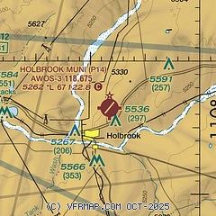
|
| Airport distance calculator |
|---|
|
|
| Sunrise and sunset |
|---|
|
Times for 11-Jun-2026
| | Local
(UTC-7) | | Zulu
(UTC) |
|---|
| Morning civil twilight | | 04:38 | | 11:38 |
| Sunrise | | 05:07 | | 12:07 |
| Sunset | | 19:33 | | 02:33 |
| Evening civil twilight | | 20:03 | | 03:03 |
|
| Current date and time |
|---|
| Zulu (UTC) | 11-Jun-2026 14:16:02 |
|---|
| Local (UTC-7) | 11-Jun-2026 07:16:02 |
|---|
|
| METAR |
|---|
KINW
29nm W | 111356Z AUTO 11004KT 10SM CLR 20/M04 A3004 RMK AO2 SLP089 T02001044
|
KTYL
29nm S | 111355Z AUTO 18006KT 10SM CLR 22/M05 A3012 RMK AO2
|
KSOW
41nm S | 111355Z AUTO 19009KT 9SM CLR 22/M05 A3017 RMK AO2
|
KSJN
45nm SE | 111354Z AUTO 18003KT 10SM CLR 21/M06 A3009 RMK AO2 SLP080 T02061061
|
|
| TAF |
|---|
KINW
29nm W | 111120Z 1112/1212 VRB06KT P6SM SKC FM111700 33008KT P6SM SKC FM120300 24014KT P6SM FEW140
|
|
| NOTAMs |
|---|
NOTAMs are issued by the DoD/FAA and will open in a separate window not controlled by AirNav.
|
|


