FAA INFORMATION EFFECTIVE 19 FEBRUARY 2026
Location
| FAA Identifier: | SJS |
| Lat/Long: | 37-45-03.4570N 082-38-12.2340W
37-45.057617N 082-38.203900W
37.7509603,-82.6367317
(estimated) |
| Elevation: | 1221.5 ft. / 372.3 m (surveyed) |
| Variation: | 05W (1990) |
| From city: | 9 miles NE of PRESTONSBURG, KY |
| Time zone: | UTC -5 (UTC -4 during Daylight Saving Time) |
| Zip code: | 41214 |
Airport Operations
| Airport use: | Open to the public |
| Activation date: | 04/1986 |
| Control tower: | no |
| ARTCC: | INDIANAPOLIS CENTER |
| FSS: | LOUISVILLE FLIGHT SERVICE STATION |
| NOTAMs facility: | LOU (NOTAM-D service available) |
| Attendance: | 0800-DUSK |
| Wind indicator: | lighted |
| Segmented circle: | yes |
| Lights: | ACTVT REIL RWY 03 & 21; MIRL RWY 03/21 - CTAF. PAPI RWY 03 & 21 OPR CONSLY. |
| Beacon: | white-green (lighted land airport)
Operates sunset to sunrise. |
Airport Communications
| CTAF/UNICOM: | 123.05 |
| WX AWOS-3: | 120.175 (606-298-4143) |
| HUNTINGTON APPROACH: | 119.75 |
| HUNTINGTON DEPARTURE: | 119.75 |
| WX AWOS-3PT at PBX (12 nm S): | 121.225 (606-437-6701) |
Airport Services
| Fuel available: | 100LL JET-A+ |
| Parking: | tiedowns |
Runway Information
Runway 3/21
| Dimensions: | 5051 x 100 ft. / 1540 x 30 m |
| Surface: | asphalt, in excellent condition |
| Weight bearing capacity: | | PCN 7 /F/D/X/T | | Single wheel: | 19.0 |
|
| Runway edge lights: | medium intensity |
| RUNWAY 3 | | RUNWAY 21 |
| Latitude: | 37-44.701332N | | 37-45.413890N |
| Longitude: | 082-38.474515W | | 082-37.933243W |
| Elevation: | 1169.6 ft. | | 1221.0 ft. |
| Traffic pattern: | left | | left |
| Runway heading: | 036 magnetic, 031 true | | 216 magnetic, 211 true |
| Displaced threshold: | no | | 49 ft. |
| Markings: | nonprecision, in good condition | | nonprecision, in good condition |
| Visual slope indicator: | 2-light PAPI on left (4.00 degrees glide path)
PAPI UNUSBL BYD 6 DEGS RIGHT OF CNTRLN. | | 2-light PAPI on left (3.00 degrees glide path) |
| Runway end identifier lights: | yes | | yes |
| Touchdown point: | yes, no lights | | yes, no lights |
| Obstructions: | 72 ft. pole, 1391 ft. from runway, 191 ft. left of centerline, 16:1 slope to clear | | 8 ft. tree, 316 ft. from runway, 218 ft. left of centerline, 14:1 slope to clear |
Airport Ownership and Management from official FAA records
| Ownership: | Publicly-owned |
| Owner: | BIG SANDY REGIONAL AIRPORT BD
2960 AIRPORT ROAD
DEBORD, KY 41214
Phone (606) 369-6818 |
| Manager: | GARY COX
2960 AIRPORT ROAD
DEBORD, KY 41214
Phone 606-298-5930
AFT HR SVC - 606-371-3793. |
Additional Remarks
| - | BIRDS & DEER ON & INVOF ARPT. |
| - | FOR CD CTC HUNTINGTON ATCT AT 304-453-2490. |
Instrument Procedures
NOTE: All procedures below are presented as PDF files. If you need a reader for these files, you should download the free Adobe Reader.NOT FOR NAVIGATION. Please procure official charts for flight.
FAA instrument procedures published for use from 19 February 2026 at 0901Z to 19 March 2026 at 0900Z.
IAPs - Instrument Approach Procedures |
|---|
| RNAV (GPS) RWY 03 | |
download (226KB) |
| RNAV (GPS) RWY 21 | |
download (225KB) |
| NOTE: Special Alternate Minimums apply | |
download (162KB) |
| NOTE: Special Take-Off Minimums/Departure Procedures apply | |
download (372KB) |
Other nearby airports with instrument procedures:
KPBX - Pike County Airport-Hatcher Field (12 nm S)
KEBD - Southern West Virginia Regional Airport (25 nm E)
KJKL - Julian Carroll Airport (34 nm W)
6L4 - Logan County Airport (35 nm E)
KCPF - Wendell H Ford Airport (37 nm SW)
|
|

Road maps at:
MapQuest
Bing
Google
| Aerial photo |
|---|
WARNING: Photo may not be current or correct
 Photo by Bernard Green
Photo taken 04-Jun-2017
looking north-northeast.
Photo by Bernard Green
Photo taken 04-Jun-2017
looking north-northeast.
Do you have a better or more recent aerial photo of Big Sandy Regional Airport that you would like to share? If so, please send us your photo.
|
| Sectional chart |
|---|
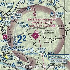
|
| Airport distance calculator |
|---|
|
|
| Sunrise and sunset |
|---|
|
Times for 15-Mar-2026
| | Local
(UTC-4) | | Zulu
(UTC) |
|---|
| Morning civil twilight | | 07:17 | | 11:17 |
| Sunrise | | 07:43 | | 11:43 |
| Sunset | | 19:36 | | 23:36 |
| Evening civil twilight | | 20:03 | | 00:03 |
|
| Current date and time |
|---|
| Zulu (UTC) | 15-Mar-2026 12:06:16 |
|---|
| Local (UTC-4) | 15-Mar-2026 08:06:16 |
|---|
|
| METAR |
|---|
| KSJS | AWOS-3 120.175 606-298-4143
151155Z AUTO 16007KT 10SM CLR 16/M01 A2997 RMK AO2 T01601007 10163 20102
|
KPBX
12nm S | 151155Z AUTO 16004KT 10SM CLR 16/00 A2998 RMK AO2 T01571001 10163 20145
|
|
| TAF |
|---|
| KSJS | 150543Z 1506/1606 16006KT P6SM FEW130 FEW250 WS020/19035KT FM151400 16010G26KT P6SM FEW070 FEW250 FM152000 18015G29KT P6SM BKN250 FM160000 18012G22KT P6SM OVC250
|
|
| NOTAMs |
|---|
NOTAMs are issued by the DoD/FAA and will open in a separate window not controlled by AirNav.
|
|

