FAA INFORMATION EFFECTIVE 14 MAY 2026
Location
| FAA Identifier: | 6L4 |
| Lat/Long: | 37-51-20.4700N 081-54-57.1800W
37-51.341167N 081-54.953000W
37.8556861,-81.9158833
(estimated) |
| Elevation: | 1666.4 ft. / 507.9 m (surveyed) |
| Variation: | 07W (2000) |
| From city: | 4 miles E of LOGAN, WV |
| Time zone: | UTC -4 (UTC -5 during Standard Time) |
| Zip code: | 25076 |
Airport Operations
| Airport use: | Open to the public |
| Activation date: | 04/1993 |
| Control tower: | no |
| ARTCC: | INDIANAPOLIS CENTER |
| FSS: | ELKINS FLIGHT SERVICE STATION [703-724-4288] |
| NOTAMs facility: | EKN (NOTAM-D service available) |
| Attendance: | 0900-1700 |
| Wind indicator: | lighted, CNTR FLD WS NOT VER, WND INDC UNRELBL. ADNL WS AT RWY 6 & 24 ENDS UNLGTD. |
| Segmented circle: | yes |
| Lights: | ACTVT REIL RWY 06 & 24; PAPI RWY 06 & 24; MIRL RWY 06/24 - CTAF. |
| Beacon: | white-green (lighted land airport)
Operates sunset to sunrise. |
Airport Communications
| CTAF: | 122.9 |
| WX AWOS-3PT: | 119.375 (304-752-0814) |
| CHARLESTON APPROACH: | 119.2 ;NORTH |
| CHARLESTON DEPARTURE: | 119.2 ;NORTH |
| IC: | 119.2 ;NORTH |
- APCH/DEP SVC PRVDD BY INDIANAPOLIS ARTCC (ZID) ON FREQS 126.575/257.85 (BLUEFIELD RCAG) FM THE SOUTH IF LOST COMM WITH CRW.
Nearby radio navigation aids
| VOR radial/distance | | VOR name | | Freq | | Var |
|---|
| HVQr196/30.4 | | CHARLESTON VOR/DME | | 117.40 | | 03W |
Airport Services
| Fuel available: | 100LL JET-A
100LL:24 HR SELF-SVC. |
| Parking: | hangars and tiedowns |
| Airframe service: | MAJOR
FOR ACFT MAINT SVCS CALL 304-752-0094 DAYS, 304-946-4415 NIGHTS. |
| Powerplant service: | MAJOR |
Runway Information
Runway 6/24
| Dimensions: | 3605 x 75 ft. / 1099 x 23 m |
| Surface: | asphalt, in fair condition |
| Runway edge lights: | medium intensity |
| RUNWAY 6 | | RUNWAY 24 |
| Latitude: | 37-51.183225N | | 37-51.498855N |
| Longitude: | 081-55.270930W | | 081-54.636468W |
| Elevation: | 1654.1 ft. | | 1666.4 ft. |
| Traffic pattern: | left | | left |
| Runway heading: | 065 magnetic, 058 true | | 245 magnetic, 238 true |
| Markings: | nonprecision, in fair condition | | nonprecision, in fair condition |
| Visual slope indicator: | 2-light PAPI on left (3.00 degrees glide path) | | 2-light PAPI on left (3.00 degrees glide path) |
| Runway end identifier lights: | yes | | yes |
| Touchdown point: | yes, no lights | | yes, no lights |
| Obstructions: | 77 ft. trees, 1000 ft. from runway, 97 ft. right of centerline, 10:1 slope to clear | | 10 ft. trees, 337 ft. from runway, 337 ft. both sides of centerline, 13:1 slope to clear |
Airport Ownership and Management from official FAA records
| Ownership: | Publicly-owned |
| Owner: | LOGAN COUNTY ARPT AUTH
PO BOX 1973
LOGAN, WV 25601
Phone 304-752-0975 |
| Manager: | MEGAN R JOHNSON
P O BOX 1793
LOGAN, WV 25601
Phone 304-752-0975 |
Additional Remarks
| - | RWY 06, 30 FT HILL 800 FT FROM THLD LEFT. |
| - | LOW LVL C-130 MIL OPNS IN VCNTY. CK NOTAMS. |
| - | DEER AND WILDLIFE ON & INVOF ARPT. |
| - | AIRPORT ACCESS CODE- CTAF. |
| - | FOR CD CTC CHARLESTON APCH AT 304-344-5867 EXT 281. |
| - | MILITARY PRACTICE RWY 1.2 MILES NE OF RWY 24 END. NOT CHARTED. |
Instrument Procedures
NOTE: All procedures below are presented as PDF files. If you need a reader for these files, you should download the free Adobe Reader.NOT FOR NAVIGATION. Please procure official charts for flight.
FAA instrument procedures published for use from 14 May 2026 at 0901Z to 11 June 2026 at 0900Z.
IAPs - Instrument Approach Procedures |
|---|
| RNAV (GPS) RWY 06 | |
download (244KB) |
| RNAV (GPS) RWY 24 **CHANGED** | |
download (187KB) |
| NOTE: Special Alternate Minimums apply **CHANGED** | |
download (145KB) |
| NOTE: Special Take-Off Minimums/Departure Procedures apply | |
download (149KB) |
Other nearby airports with instrument procedures:
KEBD - Southern West Virginia Regional Airport (14 nm SW)
I16 - Kee Field Airport (23 nm SE)
KCRW - West Virginia International Yeager Airport (35 nm NE)
KSJS - Big Sandy Regional Airport (35 nm W)
KPBX - Pike County Airport-Hatcher Field (36 nm SW)
|
|

Road maps at:
MapQuest
Bing
Google
| Aerial photo |
|---|
WARNING: Photo may not be current or correct
 Photo taken 02-Sep-2005
Do you have a better or more recent aerial photo of Logan County Airport that you would like to share? If so, please send us your photo.
|
| Sectional chart |
|---|
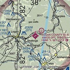
|
| Airport distance calculator |
|---|
|
|
| Sunrise and sunset |
|---|
|
Times for 06-Jun-2026
| | Local
(UTC-4) | | Zulu
(UTC) |
|---|
| Morning civil twilight | | 05:36 | | 09:36 |
| Sunrise | | 06:07 | | 10:07 |
| Sunset | | 20:46 | | 00:46 |
| Evening civil twilight | | 21:17 | | 01:17 |
|
| Current date and time |
|---|
| Zulu (UTC) | 07-Jun-2026 00:11:02 |
|---|
| Local (UTC-4) | 06-Jun-2026 20:11:02 |
|---|
|
| METAR |
|---|
| K6L4 | 061855Z AUTO 19007G13KT 160V220 10SM FEW044 26/16 A3006 RMK AO2
|
|
| TAF |
|---|
KSJS
35nm W | 061743Z 0618/0718 24006KT P6SM SCT040 FM070000 VRB03KT P6SM SCT150 FM071400 25005KT P6SM BKN100 AMD NOT SKED
|
KCRW
35nm NE | 061720Z 0618/0718 25008G15KT P6SM FEW045 SCT230 FM070000 26006KT P6SM SCT190 FM070300 00000KT P6SM SCT200
|
KBKW
38nm E | 061720Z 0618/0718 26008G14KT P6SM SCT045 BKN190 FM070000 25005KT P6SM FEW220 FM071400 28007KT P6SM BKN090
|
KHTS
43nm NW | 061720Z 0618/0718 25008G14KT P6SM FEW060 FEW220
|
|
| NOTAMs |
|---|
NOTAMs are issued by the DoD/FAA and will open in a separate window not controlled by AirNav.
|
|

