FAA INFORMATION EFFECTIVE 16 APRIL 2026
Location
| FAA Identifier: | TOP |
| Lat/Long: | 39-04-07.7628N 095-37-20.5533W
39-04.129380N 095-37.342555W
39.0688230,-95.6223759
(estimated) |
| Elevation: | 881.3 ft. / 268.6 m (surveyed) |
| Variation: | 05E (2000) |
| From city: | 3 miles NE of TOPEKA, KS |
| Time zone: | UTC -5 (UTC -6 during Standard Time) |
| Zip code: | 66616 |
Airport Operations
| Airport use: | Open to the public |
| Activation date: | 04/1940 |
| Control tower: | yes |
| ARTCC: | KANSAS CITY CENTER |
| FSS: | WICHITA FLIGHT SERVICE STATION |
| NOTAMs facility: | TOP (NOTAM-D service available) |
| Attendance: | 0700-2000 |
| Wind indicator: | lighted |
| Segmented circle: | no |
| Lights: | WHEN ATCT CLSD ACTVT MALSR RWY 13; REIL RWY 18 & 31; VASI RWY 18 & 31; HIRL RWY 13/31; MIRL RWY 18/36 - CTAF. |
| Beacon: | white-green (lighted land airport)
Operates sunset to sunrise. |
Airport Communications
| CTAF: | 118.7 |
| UNICOM: | 122.95 |
| WX ASOS: | 121.275 (785-274-8258) |
| TOPEKA GROUND: | 121.9 [0700-1900] |
| TOPEKA TOWER: | 118.7 257.8 [0700-1900] |
| CLEARANCE DELIVERY: | 121.9 |
| WX ASOS at FOE (7 nm S): | PHONE 785-862-8258 |
| WX ASOS at LWC (19 nm E): | 121.225 (785-749-1309) |
- MULTICOM - 121.900.
- APCH/DEP CTL SVC PRVDD BY KANSAS CITY ARTCC (ZKC) ON FREQS 123.8/343.7 (TOPEKA RCAG).
Nearby radio navigation aids
| VOR radial/distance | | VOR name | | Freq | | Var |
|---|
| TOPr215/5.3 | | TOPEKA VORTAC | | 117.80 | | 05E |
| NDB name | | Hdg/Dist | | Freq | | Var | | ID |
|---|
| BILOY | | 131/4.3 | | 521 | | 05E | | TO | - --- |
Airport Services
| Fuel available: | 100LL JET-A
100LL:FOR FUEL AFTER HOURS CALL 785-234-2602. |
| Parking: | hangars and tiedowns |
| Airframe service: | MAJOR |
| Powerplant service: | MAJOR |
| Bottled oxygen: | LOW |
| Bulk oxygen: | NONE |
Runway Information
Runway 13/31
| Dimensions: | 5099 x 100 ft. / 1554 x 30 m |
| Surface: | asphalt, in good condition |
| Weight bearing capacity: | | PCN 19 /F/C/Y/U | | Single wheel: | 50.0 | | Double wheel: | 72.0 | | Double tandem: | 110.0 |
|
| Runway edge lights: | high intensity |
| RUNWAY 13 | | RUNWAY 31 |
| Latitude: | 39-04.487250N | | 39-03.900235N |
| Longitude: | 095-37.622750W | | 095-36.852052W |
| Elevation: | 879.7 ft. | | 875.5 ft. |
| Traffic pattern: | left | | left |
| Runway heading: | 129 magnetic, 134 true | | 309 magnetic, 314 true |
| Markings: | precision, in good condition | | precision, in good condition |
| Visual slope indicator: | | | 4-box VASI on left (3.00 degrees glide path) |
| Approach lights: | MALSR: 1,400 foot medium intensity approach lighting system with runway alignment indicator lights | | |
| Runway end identifier lights: | | | yes |
| Touchdown point: | yes, no lights | | yes, no lights |
| Instrument approach: | ILS | | |
| Obstructions: | 107 ft. tree, 2476 ft. from runway, 920 ft. right of centerline, 21:1 slope to clear | | 52 ft. tree, 340 ft. from runway, 410 ft. left of centerline, 2:1 slope to clear |
Runway 18/36
| Dimensions: | 4331 x 75 ft. / 1320 x 23 m |
| Surface: | asphalt, in good condition |
| Weight bearing capacity: | | PCN 23 /F/C/Y/U | | Single wheel: | 60.0 | | Double wheel: | 80.0 | | Double tandem: | 96.0 |
|
| Runway edge lights: | medium intensity |
| RUNWAY 18 | | RUNWAY 36 |
| Latitude: | 39-04.410200N | | 39-03.697008N |
| Longitude: | 095-37.452968W | | 095-37.479747W |
| Elevation: | 879.8 ft. | | 880.7 ft. |
| Traffic pattern: | left | | left |
| Runway heading: | 177 magnetic, 182 true | | 357 magnetic, 002 true |
| Markings: | nonprecision, in fair condition | | nonprecision, in fair condition |
| Visual slope indicator: | 4-box VASI on left (3.00 degrees glide path) | | 4-box VASI on right (3.00 degrees glide path) |
| Runway end identifier lights: | yes | | |
| Touchdown point: | yes, no lights | | yes, no lights |
| Obstructions: | none | | 35 ft. trees, 658 ft. from runway, 313 ft. right of centerline, 13:1 slope to clear |
Airport Ownership and Management from official FAA records
| Ownership: | Publicly-owned |
| Owner: | METRO. TOPEKA ARPT AUTH.
FORBES FIELD, 6510 SE FORBES AVE
TOPEKA, KS 66619-1446
Phone 785-862-2362 |
| Manager: | ERIC M. JOHNSON
FORBES FIELD, 6510 SE FORBES AVE
TOPEKA, KS 66619
Phone 785-862-2362 |
Additional Remarks
| - | LARGE & SMALL MIGRATORY BIRDS ON & INVOF ARPT. |
| - | FOR CD IF UNA TO CTC ON FSS FREQ, CTC KANSAS CITY ARTCC AT 913-254-8508. |
Instrument Procedures
NOTE: All procedures below are presented as PDF files. If you need a reader for these files, you should download the free Adobe Reader.NOT FOR NAVIGATION. Please procure official charts for flight.
FAA instrument procedures published for use from 16 April 2026 at 0901Z to 14 May 2026 at 0900Z.
IAPs - Instrument Approach Procedures |
|---|
| ILS OR LOC RWY 13 | |
download (288KB) |
| RNAV (GPS) RWY 13 | |
download (228KB) |
| RNAV (GPS) RWY 18 | |
download (234KB) |
| RNAV (GPS) RWY 31 | |
download (220KB) |
| RNAV (GPS) RWY 36 | |
download (232KB) |
| LOC BC RWY 31 | |
download (252KB) |
| NOTE: Special Alternate Minimums apply | |
download (54KB) |
| NOTE: Special Take-Off Minimums/Departure Procedures apply | |
download (213KB) |
Other nearby airports with instrument procedures:
KFOE - Topeka Regional Airport (7 nm S)
KLWC - Lawrence Regional Airport (19 nm E)
KOWI - Ottawa Municipal Airport (36 nm SE)
KIXD - New Century AirCenter Airport (37 nm E)
KFLV - Sherman Army Airfield (37 nm NE)
|
|

Road maps at:
MapQuest
Bing
Google
| Aerial photo |
|---|
WARNING: Photo may not be current or correct
 Photo taken 02-Sep-2007
Do you have a better or more recent aerial photo of Philip Billard Municipal Airport that you would like to share? If so, please send us your photo.
|
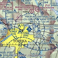
| Sectional chart |
|---|
|
CAUTION: Diagram may not be current
 Download PDF
of official airport diagram from the FAA
| Airport distance calculator |
|---|
|
|
| Sunrise and sunset |
|---|
|
Times for 23-Apr-2026
| | Local
(UTC-5) | | Zulu
(UTC) |
|---|
| Morning civil twilight | | 06:07 | | 11:07 |
| Sunrise | | 06:36 | | 11:36 |
| Sunset | | 20:06 | | 01:06 |
| Evening civil twilight | | 20:34 | | 01:34 |
|
| Current date and time |
|---|
| Zulu (UTC) | 23-Apr-2026 20:41:53 |
|---|
| Local (UTC-5) | 23-Apr-2026 15:41:53 |
|---|
|
| METAR |
|---|
| KTOP | 231953Z 18016G28KT 10SM FEW031 BKN038 OVC060 24/18 A2957 RMK AO2 PK WND 18033/1939 SLP005 T02440178
|
KFOE
8nm S | 231953Z 18017G28KT 10SM BKN030 BKN039 OVC050 24/18 A2957 RMK AO2 PK WND 18033/1910 SLP003 T02390178 $
|
KLWC
19nm E | 231952Z AUTO 18018G30KT 10SM BKN027 BKN039 OVC050 24/18 A2959 RMK AO1 PK WND 14034/1911 SLP011 T02390183
|
|
| TAF |
|---|
| KTOP | 231720Z 2318/2418 17012G24KT P6SM BKN022 FM232100 18012G24KT P6SM SCT035 FM240000 20013G21KT 1SM -SHRA VCTS OVC017CB TEMPO 2400/2402 VRB20G40KT 2SM TSRA BKN012CB FM240200 22010KT P6SM SCT030 BKN050 FM240700 35008KT P6SM SCT200
|
KFOE
8nm S | 231720Z 2318/2418 18014G25KT P6SM BKN020 FM232100 19012G24KT P6SM SCT035 FM240000 20014G22KT 1SM -SHRA VCTS OVC015CB TEMPO 2400/2402 VRB20G40KT 2SM TSRA BKN010CB FM240200 24012KT P6SM SCT030 BKN050 FM240700 35010KT P6SM SCT200
|
|
| NOTAMs |
|---|
NOTAMs are issued by the DoD/FAA and will open in a separate window not controlled by AirNav.
|
|


