FAA INFORMATION EFFECTIVE 18 APRIL 2024
Location
| FAA Identifier: | TVL |
| Lat/Long: | 38-53-38.0000N 119-59-43.2000W
38-53.633333N 119-59.720000W
38.8938889,-119.9953333
(estimated) |
| Elevation: | 6268.4 ft. / 1910.6 m (surveyed) |
| Variation: | 16E (1985) |
| From city: | 3 miles SW of SOUTH LAKE TAHOE, CA |
| Time zone: | UTC -7 (UTC -8 during Standard Time) |
| Zip code: | 96150 |
Airport Operations
| Airport use: | Open to the public |
| Control tower: | no |
| ARTCC: | OAKLAND CENTER |
| FSS: | RENO FLIGHT SERVICE STATION |
| NOTAMs facility: | TVL (NOTAM-D service available) |
| Attendance: | 0700-1600 |
| Wind indicator: | lighted |
| Segmented circle: | yes |
| Lights: | ACTVT MALSF RWY 18; PAPI RWY 18, MIRL RW 18/36 - CTAF. |
| Beacon: | white-green (lighted land airport)
Operates sunset to sunrise. |
| Taxiway lights: | APRON ENTRANCE TWYS AND HIGH SPEED TWYS ONLY. |
Airport Communications
| CTAF: | 122.85 |
| WX ASOS: | 124.725 (530-541-5739) |
| WX AWOS-3PT at MEV (13 nm NE): | 119.325 (775-782-6264) |
- MULTICOM 122.85
- APCH/DEP CTL SVC PRVDD BY OAKLAND ARTCC (ZOA) ON FREQ 127.95 (SQUAW VALLEY RCAG) AND FREQ 316.1 (SACRAMENTO RCAG). CLNC DEL PRVDD BY OAKLAND ARTCC ON FREQ 134.3 (SOUTH LAKE TAHOE RCAG).
- COMMUNICATIONS PRVDD BY RENO RADIO ON FREQ 122.5 (SQUAW VALLEY RCO).
Nearby radio navigation aids
| VOR radial/distance | | VOR name | | Freq | | Var |
|---|
| SWRr127/21.4 | | PALISADES VOR/DME | | 113.20 | | 16E |
| HNWr057/36.7 | | HANGTOWN VOR/DME | | 115.50 | | 17E |
Airport Services
| Fuel available: | 100LL JET-A |
| Airframe service: | MINOR |
| Powerplant service: | MINOR |
| Bottled oxygen: | HIGH |
| Bulk oxygen: | HIGH |
Runway Information
Runway 18/36
| Dimensions: | 8541 x 100 ft. / 2603 x 30 m |
| Surface: | asphalt/grooved, in excellent condition |
| Weight bearing capacity: | | Single wheel: | 70.0 | | Double wheel: | 125.0 | | Double tandem: | 210.0 |
|
| Runway edge lights: | medium intensity |
| RUNWAY 18 | | RUNWAY 36 |
| Latitude: | 38-54.319350N | | 38-52.948300N |
| Longitude: | 119-59.519183W | | 119-59.921452W |
| Elevation: | 6254.6 ft. | | 6268.3 ft. |
| Traffic pattern: | left | | right |
| Runway heading: | 177 magnetic, 193 true | | 357 magnetic, 013 true |
| Displaced threshold: | 800 ft. | | 2033 ft. |
| Declared distances: | TORA:8541 TODA:8541 ASDA:7817 LDA:7017 | | TORA:8541 TODA:8541 ASDA:7741 LDA:5708 |
| Markings: | nonprecision, in good condition | | basic, in good condition |
| Visual slope indicator: | 4-light PAPI on left (3.00 degrees glide path)
UNUSBL BYD 2 DEG LEFT OF RWY CNTRLN & BYD 3 NM. | | |
| Approach lights: | MALSF: 1,400 foot medium intensity approach lighting system with sequenced flashers | | |
| Runway end identifier lights: | no | | yes |
| Touchdown point: | yes, no lights | | yes, no lights |
| Instrument approach: | LDA/DME | | |
| Obstructions: | 13 ft. brush, 450 ft. from runway, 125 ft. left of centerline, 19:1 slope to clear | | 345 ft. trees, 5700 ft. from runway, 500 ft. right of centerline, 15:1 slope to clear
APCH RATIO 22:1 TO DSPLCD THLD. |
Airport Ownership and Management from official FAA records
| Ownership: | Publicly-owned |
| Owner: | SOUTH LAKE TAHOE
1901 LISA MALOFF WAY, SUITE 100
SOUTH LAKE TAHOE, CA 96150
Phone 530-542-6182 |
| Manager: | JOHN DICKINSON
1901 LISA MALOFF WAY, SUITE 100
SOUTH LAKE TAHOE, CA 96150
Phone 530-542-6182 |
Airport Operational Statistics
| Aircraft based on the field: | | 21 | | Single engine airplanes: | | 18 | | Multi engine airplanes: | | 1 | | Helicopters: | | 2 |
| |  | |
| Aircraft operations: avg 27/day * | | 82% | transient general aviation | | 7% | air taxi | | 7% | local general aviation | | 2% | military | | 2% | commercial | | * for 12-month period ending 31 December 2023 | |
Additional Remarks
| - | AP SFC CONDS: TRML APRON EXCELLENT, TWY - RWY GOOD, NORTH GA APRON POOR. |
| - | AFTER WINTER STORMS RY 18/36 OPENS BEFORE ALL TWYS ARE CLEAR. |
| - | PREFERRED ARRIVAL RY 18; PREFERRED DEP RY 36. |
| - | RECREATIONAL AIRBORNE ACTIVITY ALONG SOUTHERN LAKE SHORE. |
| - | FOR LARGE AND HIGH PERFORMANCE ACFT DEP RY 18; RIGHT DOWNWIND DEP RECOMMENDED. |
| - | BIRDS AND WATERFOWL INVOF ARPT. |
| - | ADVERSE WEATHER EFFECTS MAGNIFIED BY MOUNTAINS. |
| - | TFC ADVISORIES & SEQUENCING IN THE TFC PAT ARE BASED ON POSITION REPORTS RECEIVED FROM PILOTS IN THESE AREAS. |
| - | ARPT SURROUNDED ON E; S & W BY RAPIDLY RISING TERRAIN. |
| - | ACCESS NOISE RESTRICTIONS: MAX 80 DBA DEP, 84 DBA ARR (TRANSPORT - 86 DBA), MAX 77.1 DBA NIGHT LIMIT. |
| - | NOISE ABATEMENT, DEP RWY 36 HDG 1 MILE, LEFT 320 DEG TO SHORELINE. |
| - | FOR NOISE ABATEMENT INFO CALL (530) 542-6182. |
| - | AVOID DESOLATION WILDERNESS WEST OF ARPT. |
| - | AP CONDS NOT MMT 1600-0700 DLY. |
| - | TWY H CLSD PERM. |
| - | TPA 7500' MSL FOR SMALL ACFT; 8000' MSL FOR TRANSPORT/HIGH PERFORMANCE ACFT. |
| - | PARAGLIDERS AND MOTORIZED PRCHTS OPR FROM RWY SFC. |
| - | AP CONDS NOT MNT SAT/SUN. |
| - | COLD TEMPERATURE AIRPORT. ALTITUDE CORRECTION REQUIRED AT OR BELOW -13C. |
Instrument Procedures
NOTE: All procedures below are presented as PDF files. If you need a reader for these files, you should download the free Adobe Reader.NOT FOR NAVIGATION. Please procure official charts for flight.
FAA instrument procedures published for use from 18 April 2024 at 0901Z to 16 May 2024 at 0900Z.
IAPs - Instrument Approach Procedures |
|---|
| RNAV (GPS) RWY 18 **CHANGED** | |
download (368KB) |
| LDA RWY 18 | |
download (362KB) |
Departure Procedures |
|---|
| RICHY SEVEN | |
download (207KB) |
| NOTE: Special Take-Off Minimums/Departure Procedures apply | |
download (246KB) |
Other nearby airports with instrument procedures:
KMEV - Minden-Tahoe Airport (13 nm NE)
KCXP - Carson City Airport (22 nm NE)
KTRK - Truckee-Tahoe Airport (26 nm N)
KPVF - Placerville Airport (37 nm W)
KRNO - Reno/Tahoe International Airport (38 nm N)
|
|

Road maps at:
MapQuest
Bing
Google
| Aerial photo |
|---|
WARNING: Photo may not be current or correct
 Photo taken 24-Mar-2013
looking west.
Photo taken 24-Mar-2013
looking west.
Do you have a better or more recent aerial photo of Lake Tahoe Airport that you would like to share? If so, please send us your photo.
|
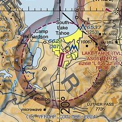
| Sectional chart |
|---|
|
CAUTION: Diagram may not be current
 Download PDF
of official airport diagram from the FAA
| Airport distance calculator |
|---|
|
|
| Sunrise and sunset |
|---|
|
Times for 18-Apr-2024
| | Local
(UTC-7) | | Zulu
(UTC) |
|---|
| Morning civil twilight | | 05:51 | | 12:51 |
| Sunrise | | 06:19 | | 13:19 |
| Sunset | | 19:40 | | 02:40 |
| Evening civil twilight | | 20:07 | | 03:07 |
|
| Current date and time |
|---|
| Zulu (UTC) | 19-Apr-2024 04:03:26 |
|---|
| Local (UTC-7) | 18-Apr-2024 21:03:26 |
|---|
|
| METAR |
|---|
| KTVL | 190353Z AUTO 00000KT 10SM CLR 08/03 A3008 RMK AO2 SLP155 T00830033
|
KMEV
13nm NE | 190355Z AUTO 08004KT 10SM CLR 14/03 A3000 RMK AO2
|
|
| TAF |
|---|
| KTVL | 181720Z 1818/1918 04004KT P6SM FEW250 FM182100 20008KT P6SM SCT250 FM190100 18003KT P6SM BKN250
|
KMEV
13nm NE | 181720Z 1818/1918 VRB05KT P6SM FEW250 FM182300 29010G20KT P6SM SCT250 FM190200 34007KT P6SM BKN250 FM190400 10006KT P6SM BKN250 FM191200 VRB02KT P6SM BKN250
|
|
| NOTAMs |
|---|
NOTAMs are issued by the DoD/FAA and will open in a separate window not controlled by AirNav.
|
|


