FAA INFORMATION EFFECTIVE 15 MAY 2025
Location
| FAA Identifier: | X59 |
| Lat/Long: | 27-57-39.1160N 080-33-29.9800W
27-57.651933N 080-33.499667W
27.9608656,-80.5583278
(estimated) |
| Elevation: | 25.8 ft. / 7.9 m (surveyed) |
| Variation: | 07W (2025) |
| From city: | 1 mile W of VALKARIA, FL |
| Time zone: | UTC -4 (UTC -5 during Standard Time) |
| Zip code: | 32950 |
Airport Operations
| Airport use: | Open to the public |
| Activation date: | 12/1946 |
| Control tower: | no |
| ARTCC: | JACKSONVILLE CENTER |
| FSS: | SAINT PETERSBURG FLIGHT SERVICE STATION |
| NOTAMs facility: | PIE (NOTAM-D service available) |
| Attendance: | MON-FRI 0800-1700 |
| Wind indicator: | lighted |
| Segmented circle: | yes |
| Lights: | APLG NOT OPR DURG DALGT HOURS. SS-SR, ACTVT MIRL 14/32- CTAF. |
| Beacon: | white-green (lighted land airport)
Operates sunset to sunrise. |
Airport Communications
| CTAF/UNICOM: | 122.725 |
| WX AWOS-3PT: | 119.525 |
| ORLANDO APPROACH: | 132.65 |
| ORLANDO DEPARTURE: | 132.65 |
| WX AWOS-3PT at X26 (9 nm S): | 118.125 (772-228-7020) |
| WX ASOS at MLB (10 nm NW): | 132.55 (321-951-7575) |
| WX ASOS at VRB (20 nm S): | 120.575 (772-978-9535) |
Nearby radio navigation aids
| VOR radial/distance | | VOR name | | Freq | | Var |
|---|
| MLBr162/9.6 | | MELBOURNE VOR/DME | | 115.85 | | 07W |
| TRVr355/17.3 | | TREASURE VORTAC | | 117.30 | | 07W |
Airport Services
| Fuel available: | 100LL |
| Parking: | tiedowns |
| Airframe service: | MAJOR |
| Powerplant service: | MAJOR |
| Bottled oxygen: | NONE |
| Bulk oxygen: | NONE |
Runway Information
Runway 10/28
| Dimensions: | 4000 x 75 ft. / 1219 x 23 m |
| Surface: | asphalt, in fair condition |
| Weight bearing capacity: | | PCN 6 /F/B/Y/T | | Single wheel: | 12.5 |
|
| RUNWAY 10 | | RUNWAY 28 |
| Latitude: | 27-57.574833N | | 27-57.572667N |
| Longitude: | 080-33.947167W | | 080-33.203500W |
| Elevation: | 23.5 ft. | | 25.7 ft. |
| Traffic pattern: | left | | left |
| Markings: | basic, in fair condition | | basic, in fair condition |
| Visual slope indicator: | | | 4-light PAPI on right (3.00 degrees glide path) |
| Touchdown point: | yes, no lights | | yes, no lights |
| Obstructions: | 30 ft. trees, 502 ft. from runway, 70 ft. left of centerline, 10:1 slope to clear | | 16 ft. trees, 395 ft. from runway, 80 ft. left of centerline, 12:1 slope to clear |
Runway 14/32
| Dimensions: | 4000 x 75 ft. / 1219 x 23 m |
| Surface: | asphalt, in good condition |
| Weight bearing capacity: | | PCN 8 /F/A/Y/T | | Single wheel: | 12.5 |
|
| Runway edge lights: | medium intensity |
| RUNWAY 14 | | RUNWAY 32 |
| Latitude: | 27-57.974538N | | 27-57.485717N |
| Longitude: | 080-33.673700W | | 080-33.174217W |
| Elevation: | 24.6 ft. | | 24.2 ft. |
| Traffic pattern: | left | | left |
| Markings: | nonprecision, in fair condition | | nonprecision, in fair condition |
| Visual slope indicator: | 4-light PAPI on right (3.00 degrees glide path) | | 4-light PAPI on left (3.00 degrees glide path) |
| Touchdown point: | yes, no lights | | yes, no lights |
| Obstructions: | 22 ft. trees, 450 ft. from runway, 115 ft. left of centerline, 11:1 slope to clear | | 24 ft. trees, 470 ft. from runway, 60 ft. left of centerline, 11:1 slope to clear |
Airport Ownership and Management from official FAA records
| Ownership: | Publicly-owned |
| Owner: | BREVARD COUNTY
2725 JUDGE FRAN JAMIESON WAY, BUILDING C SUITE 301
VIERA, FL 32940
Phone (321) 633-2001 |
| Manager: | PHILLIP HIED
1 PILOT'S PLACE
VALKARIA, FL 32950
Phone 321-952-4590
PHILLIP HIED |
Additional Remarks
| - | USE CTN EXTSV PWRD PARAGLIDER OPS. |
| - | FOR CD OR TO CNL IFR CTC ORLANDO APCH AT 407-852-7500. |
| - | AWOS 119.525 |
| - | TSNT GATE CODE 1467. |
| - | REFRAIN FM TOUCH & GO OPNS IF THERE ARE 3 OR MORE ACFT IN THE TFC PAT. |
| - | TRSNT ACFT PLEASE PARK ON TARMAC BTN ARPT BCN AND TRML. |
Instrument Procedures
NOTE: All procedures below are presented as PDF files. If you need a reader for these files, you should download the free Adobe Reader.NOT FOR NAVIGATION. Please procure official charts for flight.
FAA instrument procedures published for use from 15 May 2025 at 0901Z to 13 June 2025 at 0900z.
IAPs - Instrument Approach Procedures |
|---|
| RNAV (GPS)-A | |
download (174KB) |
| RNAV (GPS)-A | |
download (174KB) |
| RNAV (GPS)-B | |
download (183KB) |
| RNAV (GPS)-B | |
download (183KB) |
| NOTE: Special Alternate Minimums apply | |
download (149KB) |
| NOTE: Special Alternate Minimums apply | |
download (149KB) |
| NOTE: Special Take-Off Minimums/Departure Procedures apply | |
download (409KB) |
| NOTE: Special Take-Off Minimums/Departure Procedures apply | |
download (409KB) |
Other nearby airports with instrument procedures:
X26 - Sebastian Municipal Airport (9 nm S)
KMLB - Melbourne Orlando International Airport (10 nm NW)
KCOF - Patrick Space Force Base Airport (17 nm N)
KVRB - Vero Beach Regional Airport (20 nm S)
KCOI - Merritt Island Airport (24 nm N)
|
|

Road maps at:
MapQuest
Bing
Google
| Aerial photo |
|---|
WARNING: Photo may not be current or correct
 Photo by Lance Jackson
looking southeast
Photo by Lance Jackson
looking southeast
Do you have a better or more recent aerial photo of Valkaria Airport that you would like to share? If so, please send us your photo.
|
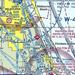
| Sectional chart |
|---|
|
| Airport distance calculator |
|---|
|
|
| Sunrise and sunset |
|---|
|
Times for 22-May-2025
| | Local
(UTC-4) | | Zulu
(UTC) |
|---|
| Morning civil twilight | | 06:04 | | 10:04 |
| Sunrise | | 06:30 | | 10:30 |
| Sunset | | 20:08 | | 00:08 |
| Evening civil twilight | | 20:34 | | 00:34 |
|
| Current date and time |
|---|
| Zulu (UTC) | 22-May-2025 04:33:06 |
|---|
| Local (UTC-4) | 22-May-2025 00:33:06 |
|---|
|
| METAR |
|---|
KX26
9nm S | 220415Z AUTO 28002KT 10SM CLR 26/21 A2995 RMK AO2
|
KMLB
10nm NW | 220353Z AUTO 27007KT 10SM CLR 26/21 A2994 RMK AO2 SLP139 T02610211
|
KCOF
15nm N | 220355Z AUTO 27010KT 10SM CLR 28/22 A2991 RMK AO2 SLP133 T02830218 $
|
|
| TAF |
|---|
KMLB
10nm NW | 211720Z 2118/2218 26010G18KT P6SM SCT040 SCT250 FM220500 VRB05KT P6SM SCT040 BKN180 FM221300 35008KT P6SM BKN050 BKN150 FM221700 04009KT P6SM SCT060 BKN150
|
KCOF
15nm N | 220200Z 2202/2308 28009KT 9999 SKC FEW030 QNH2989INS BECMG 2208/2209 27006KT 6000 BR BKN020 QNH2996INS BECMG 2213/2214 32009KT 9999 BKN020 QNH2997INS BECMG 2220/2221 03010G15KT 9999 FEW040 SCT080 QNH2998INS BECMG 2302/2303 VRB06KT 9999 FEW100 QNH2997INS TX30/2218Z TN23/2210Z LAST NO AMDS AFT 2204 NEXT 2210
|
|
| NOTAMs |
|---|
NOTAMs are issued by the DoD/FAA and will open in a separate window not controlled by AirNav.
|
|


