FAA INFORMATION EFFECTIVE 16 MAY 2024
Location
| FAA Identifier: | 49N |
| Lat/Long: | 40-49-29.3550N 072-45-03.3590W
40-49.489250N 072-45.055983W
40.8248208,-72.7509331
(estimated) |
| Elevation: | 57 ft. / 17 m (estimated) |
| Variation: | 14W (1985) |
| From city: | 1 mile NE of EAST MORICHES, NY |
| Time zone: | UTC -4 (UTC -5 during Standard Time) |
| Zip code: | 11940 |
Airport Operations
| Airport use: | Open to the public |
| Activation date: | 09/1973 |
| Control tower: | no |
| ARTCC: | NEW YORK CENTER |
| FSS: | NEW YORK FLIGHT SERVICE STATION
FOR LOCAL CALL TO FSS DIAL 737-1000. |
| NOTAMs facility: | ISP (NOTAM-D service available) |
| Attendance: | DAYLIGHT HOURS |
| Wind indicator: | yes |
| Segmented circle: | no |
| Landing fee: | yes, $2 AFTER FIRST LANDING |
Airport Communications
| CTAF: | 122.9 |
| WX ASOS at HWV (5 nm W): | 119.625 (631-399-7095) |
| WX ASOS at FOK (6 nm E): | 119.925 (631-288-0588) |
| WX ASOS at ISP (16 nm W): | 120.725 (631-471-0131) |
Nearby radio navigation aids
| VOR radial/distance | | VOR name | | Freq | | Var |
|---|
| CCCr174/6.7 | | CALVERTON VOR/DME | | 114.55 | | 13W |
| HTOr267/20.5 | | HAMPTON VORTAC | | 113.60 | | 13W |
| DPKr097/25.2 | | DEER PARK VOR/DME | | 117.70 | | 12W |
| BDRr152/26.3 | | BRIDGEPORT VOR/DME | | 108.80 | | 12W |
| MADr198/29.5 | | MADISON VOR/DME | | 110.40 | | 13W |
Airport Services
| Parking: | hangars and tiedowns |
Runway Information
Runway N/S
| Dimensions: | 2300 x 100 ft. / 701 x 30 m
SOUTH END OF RY MARKED WITH BOARDS |
| Surface: | turf, in excellent condition |
| RUNWAY N | | RUNWAY S |
| Traffic pattern: | left | | right |
| Obstructions: | 17 ft. trees, 21 ft. from runway, 74 ft. right of centerline, 1:1 slope to clear
RWY "N", +15 FT ROAD, 0 FT FROM RWY THLD, 54 FT RT | | 46 ft. tree, 50 ft. from runway, 62 ft. left of centerline, 1:1 slope to clear
RWY "S", +15 FT ROAD 4 FT FROM RWY THLD 115 FT RT. |
Airport Ownership and Management from official FAA records
| Ownership: | Privately-owned |
| Owner: | LOUIS LUFKER
115 MONTAUK HWY
EAST MORICHES, NY 11940
Phone 631-909-1772 |
| Manager: | JAMES LUFKER
115 MONTAUK HWY
EAST MORICHES, NY 11940
Phone 516-203-5930
ASST AMGR KURT LUSKER PHONE 631-902-8293. |
Airport Operational Statistics
| Aircraft based on the field: | | 43 | | Single engine airplanes: | | 25 | | Gliders airplanes: | | 3 | | Ultralights: | | 15 |
| |  | |
| Aircraft operations: avg 39/week * | | 99% | local general aviation | | 1% | transient general aviation | | * for 12-month period ending 14 May 2018 | |
Additional Remarks
| - | BANNER TOWING OPERATION MAY-OCT. |
| - | RY "N", ARCFT TIEDOWNS, 25-30 FT RIGHT FM CNTRLN, 100-450 FM SOUTH END OF RY. |
| - | RY "N", +35 FT PWRLNS, 80 FT FM RY BEGINNING, ROAD 45 FT FM RY BEGINNING. |
| - | FOR CD CTC NEW YORK APCH AT 516-683-2449. |
| - | RY N HAS ACFT TDWN 40FT FM THLD RT. |
| - | GLIDER & ULTRALIGHT OPNS DALGT HRS MAY-OCT. |
| - | PAJA ADJ TO SAPDARO ARPT. |
| - | SPADARO ARPT TFC PATTERN 590 FT EAST. |
| - | RWY "S", +14' BRUSH, 50' FROM RWY BEG. |
Instrument Procedures
There are no published instrument procedures at 49N.
Some nearby airports with instrument procedures:
KHWV - Brookhaven Airport (5 nm W)
KFOK - Francis S Gabreski Airport (6 nm E)
87N - Southampton Heliport (13 nm E)
KISP - Long Island Mac Arthur Airport (16 nm W)
KJPX - East Hampton Town Airport (24 nm E)
|
|

Road maps at:
MapQuest
Bing
Google
| Aerial photo |
|---|
WARNING: Photo may not be current or correct
 Photo taken 12-Jul-2012
looking north.
Photo taken 12-Jul-2012
looking north.
Do you have a better or more recent aerial photo of Lufker Airport that you would like to share? If so, please send us your photo.
|
| Sectional chart |
|---|
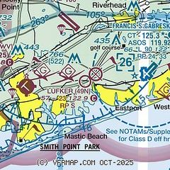
|
| Airport distance calculator |
|---|
|
|
| Sunrise and sunset |
|---|
|
Times for 19-May-2024
| | Local
(UTC-4) | | Zulu
(UTC) |
|---|
| Morning civil twilight | | 04:59 | | 08:59 |
| Sunrise | | 05:30 | | 09:30 |
| Sunset | | 20:05 | | 00:05 |
| Evening civil twilight | | 20:37 | | 00:37 |
|
| Current date and time |
|---|
| Zulu (UTC) | 20-May-2024 03:08:45 |
|---|
| Local (UTC-4) | 19-May-2024 23:08:45 |
|---|
|
| METAR |
|---|
KHWV
5nm W | 200256Z AUTO 00000KT 10SM CLR 12/11 A3004 RMK AO2 SLP172 60000 T01220106 53011
|
KFOK
6nm E | 200253Z 08003KT 10SM OVC060 15/13 A3004 RMK AO2 SLP171 T01500128 51006
|
KISP
16nm W | 200256Z 00000KT 10SM FEW060 12/11 A3004 RMK AO2 SLP170 T01220111 51013
|
|
| TAF |
|---|
KISP
16nm W | 191948Z 1920/2018 16006KT P6SM BKN030 FM192200 18005KT P6SM BKN035 FM200300 03005KT P6SM SCT035 FM200600 03005KT P6SM SCT009 OVC012 TEMPO 2009/2013 OVC009 FM201700 17007KT P6SM SCT030
|
|
| NOTAMs |
|---|
NOTAMs are issued by the DoD/FAA and will open in a separate window not controlled by AirNav.
|
|
