FAA INFORMATION EFFECTIVE 16 APRIL 2026
Location
| FAA Identifier: | ISP |
| Lat/Long: | 40-47-46.0885N 073-06-02.3942W
40-47.768142N 073-06.039903W
40.7961357,-73.1006651
(estimated) |
| Elevation: | 98.7 ft. / 30.1 m (surveyed) |
| Variation: | 14W (2000) |
| From city: | 40 miles E of NEW YORK, NY |
| Time zone: | UTC -4 (UTC -5 during Standard Time) |
| Zip code: | 11779 |
Airport Operations
| Airport use: | Open to the public |
| Activation date: | 05/1943 |
| Control tower: | yes |
| ARTCC: | NEW YORK CENTER |
| FSS: | NEW YORK FLIGHT SERVICE STATION |
| NOTAMs facility: | ISP (NOTAM-D service available) |
| Attendance: | CONTINUOUS |
| Wind indicator: | yes |
| Segmented circle: | yes |
| Lights: | DUSK TO DAWN. WHEN ATCT CLSD ACTVT MIRL RWY 15R/33L; TWY LGTS- CTAF. HIRL RWY 06/24 PRESET LOW INTST ACTVT - CTAF; MALSR RWY 06 & 24 PRESET MED INTST FOR PREVAILING WIND RWY. |
| Beacon: | white-green (lighted land airport)
Operates sunset to sunrise. |
| Landing fee: | yes, LDG FEE FOR ALL ACFT EXC MIL AND GOVT. |
| Fire and rescue: | ARFF index C |
| International operations: | customs landing rights airport
LDG FEE FOR ALL ACFT EXC MIL, GOVT AND NOT-FOR-PROFIT
MEDICAL FLIGHTS. |
Airport Communications
| CTAF: | 119.3 |
| UNICOM: | 122.95 |
| ATIS: | 120.725 |
| WX ASOS: | 120.725 (631-471-0131) |
| LONG ISLAND GROUND: | 135.3 [0600-2400] |
| LONG ISLAND TOWER: | 119.3 335.5 124.3 239.3 [0600-2400] |
| NEW YORK APPROACH: | 120.05 |
| NEW YORK DEPARTURE: | 120.05 |
| CLEARANCE DELIVERY: | 121.85 |
| ARNG OPS: | 45.0 |
| CLASS C: | 120.05 120.05 ;180-329 120.05 ;330-179 |
| EMERG: | 121.5 243.0 |
| IC: | 120.05 |
| NELIE STAR: | 120.05 |
| WX ASOS at HWV (11 nm E): | 119.625 (631-399-7095) |
| WX ASOS at FRG (15 nm W): | PHONE 631-752-8129 |
- CLASS C HRS SAME AS ATCT HRS.
Nearby radio navigation aids
| VOR radial/distance | | VOR name | | Freq | | Var |
|---|
| DPKr100/9.2 | | DEER PARK VOR/DME | | 117.70 | | 12W |
| CCCr253/15.9 | | CALVERTON VOR/DME | | 114.55 | | 13W |
| BDRr189/21.9 | | BRIDGEPORT VOR/DME | | 108.80 | | 12W |
| JFKr084/32.0 | | KENNEDY VOR/DME | | 115.90 | | 12W |
| LGAr101/34.9 | | LA GUARDIA VOR/DME | | 113.10 | | 12W |
| MADr224/36.1 | | MADISON VOR/DME | | 110.40 | | 13W |
| CMKr155/36.3 | | CARMEL VOR/DME | | 116.60 | | 12W |
| HTOr271/36.3 | | HAMPTON VORTAC | | 113.60 | | 13W |
| CRIr084/37.8 | | CANARSIE VOR/DME | | 112.30 | | 11W |
| NDB name | | Hdg/Dist | | Freq | | Var | | ID |
|---|
| LOKKS | | 059/5.7 | | 366 | | 14W | | IS | .. ... |
Airport Services
| Fuel available: | 100LL JET-A |
| Parking: | hangars and tiedowns |
| Airframe service: | MAJOR |
| Powerplant service: | MAJOR |
| Bottled oxygen: | HIGH/LOW |
| Bulk oxygen: | HIGH/LOW |
Runway Information
Runway 6/24
| Dimensions: | 7006 x 150 ft. / 2135 x 46 m |
| Surface: | asphalt/grooved, in good condition |
| Weight bearing capacity: | | Single wheel: | 100.0 | | Double wheel: | 210.0 | | Double tandem: | 300.0 |
|
| Runway edge lights: | high intensity |
| RUNWAY 6 | | RUNWAY 24 |
| Latitude: | 40-47.318170N | | 40-48.134088N |
| Longitude: | 073-06.746932W | | 073-05.673447W |
| Elevation: | 92.3 ft. | | 98.7 ft. |
| Traffic pattern: | left | | right |
| Runway heading: | 059 magnetic, 045 true | | 239 magnetic, 225 true |
| Declared distances: | TORA:7006 TODA:7006 ASDA:7006 LDA:7006 | | TORA:7006 TODA:7006 ASDA:7006 LDA:7006 |
| Markings: | precision, in good condition | | precision, in good condition |
| Visual slope indicator: | 4-light PAPI on left (3.00 degrees glide path) | | 4-light PAPI on left (3.00 degrees glide path) |
| RVR equipment: | touchdown, rollout | | touchdown, rollout |
| Approach lights: | MALSR: 1,400 foot medium intensity approach lighting system with runway alignment indicator lights
NSTD MALSR; THREE OUTERMOST FLASHER LGTS EXCEED STD SPACING. | | MALSR: 1,400 foot medium intensity approach lighting system with runway alignment indicator lights |
| Centerline lights: | yes | | yes |
| Touchdown point: | yes, no lights | | yes, no lights |
| Instrument approach: | ILS/DME | | ILS/DME |
| Obstructions: | 38 ft. tree, 1340 ft. from runway, 350 ft. left of centerline, 30:1 slope to clear | | none |
Runway 15R/33L
| Dimensions: | 5186 x 150 ft. / 1581 x 46 m |
| Surface: | asphalt/grooved, in excellent condition |
| Weight bearing capacity: | | Single wheel: | 100.0 | | Double wheel: | 170.0 | | Double tandem: | 300.0 |
|
| Runway edge lights: | medium intensity |
| RUNWAY 15R | | RUNWAY 33L |
| Latitude: | 40-48.133622N | | 40-47.529570N |
| Longitude: | 073-06.439800W | | 073-05.645432W |
| Elevation: | 98.5 ft. | | 78.5 ft. |
| Traffic pattern: | right | | left |
| Runway heading: | 149 magnetic, 135 true | | 329 magnetic, 315 true |
| Declared distances: | TORA:5186 TODA:5186 ASDA:5186 LDA:5186 | | TORA:5186 TODA:5186 ASDA:5186 LDA:5186 |
| Markings: | nonprecision, in good condition | | nonprecision, in good condition |
| Visual slope indicator: | 4-light PAPI on left (3.10 degrees glide path) | | 4-light PAPI on left (3.00 degrees glide path) |
| Touchdown point: | yes, no lights | | yes, no lights |
| Obstructions: | none | | 39 ft. trees, 1300 ft. from runway, 300 ft. right of centerline, 28:1 slope to clear |
Runway 15L/33R
| Dimensions: | 3175 x 75 ft. / 968 x 23 m |
| Surface: | asphalt, in fair condition |
| Weight bearing capacity: | |
| Runway edge markings: | NSTD MKGS, THR BAR MISG ON RWY END. |
| Operational restrictions: | RWY 15L/33R NOT AVBL FOR PART 121/PART 380 OPS WITH SKED PAX CARRYING OPS MORE THAN 9 PAX SEATS AND NON-SKED PAX CARRYING OPS MORE THAN 30 PAX SEATS. |
| RUNWAY 15L | | RUNWAY 33R |
| Latitude: | 40-47.942057N | | 40-47.572352N |
| Longitude: | 073-05.902987W | | 073-05.416442W |
| Elevation: | 91.2 ft. | | 81.4 ft. |
| Traffic pattern: | left | | right |
| Runway heading: | 149 magnetic, 135 true | | 329 magnetic, 315 true |
| Declared distances: | TORA:3175 TODA:3175 ASDA:3175 LDA:3175 | | TORA:3175 TODA:3175 ASDA:3175 LDA:3175 |
| Markings: | NSTD, in good condition | | NSTD, in good condition |
| Touchdown point: | yes, no lights | | yes, no lights |
Helipad H1
| Dimensions: | 50 x 50 ft. / 15 x 15 m |
| Surface: | asphalt, in good condition |
| Operational restrictions: | LCTD ON TWY W SOUTH OF INT OF TWY B. |
| Latitude: | 40-47.930212N | | |
| Longitude: | 073-06.432418W | | |
| Elevation: | 94.0 ft. | | |
| Traffic pattern: | left | | left |
| Markings: | basic, in good condition | | |
Helipad H2
| Dimensions: | 50 x 50 ft. / 15 x 15 m |
| Surface: | asphalt, in good condition |
| Operational restrictions: | LCTD ON TWY C NORTH OF TWY S. |
| Latitude: | 40-47.497952N | | |
| Longitude: | 073-06.056010W | | |
| Elevation: | 80.5 ft. | | |
| Traffic pattern: | left | | left |
| Markings: | basic, in good condition | | |
Airport Ownership and Management from official FAA records
| Ownership: | Publicly-owned |
| Owner: | TOWN OF ISLIP
655 MAIN ST
ISLIP, NY 11751
Phone 631-467-3300 |
| Manager: | ROBERT A. SCHNEIDER
100 ARRIVAL AVE
RONKONKOMA, NY 11779-7398
Phone 631-467-3300 |
Additional Remarks
| A39-15L/33R | PCR VALUE: 280/F/B/X/T |
| A39-06/24 | PCR VALUE: 550/F/A/X/T |
| A39-15R/33L | PCR VALUE: 590/F/B/X/T |
| - | ADZY:TFC LNDG RWY 33L HIGH DENSITY VFR TFC OPERG 600 FT MSL & BLW VCNTY BAYPORT AERODROME 3 MILES SE. |
| - | FOR CD WHEN ATCT CLSD CTC NEW YORK APCH AT 516-683-2449. |
| - | BIRD ACTVTY ON & INVOF ARPT. |
| - | TWY S UNLGTD EAST OF TRML APN. |
| - | RWY 15L/33R CLSD TO FIXED WING ACFT AT NGT & AVBL FOR TXG. |
| - | UPDRAFTS MAY BE ENCOUNTERED INVOF POWER PLANT 1.5 NM NE RWY 24. |
| - | RWY 15L/33R NOT AVBL FOR NIGHT TKOF AND LDG OPS. LIMITED TO ACFT 48,000 LBS OR LESS. |
| - | VOLUNTARY NS ABTMT PROCEDURES IN EFFECT FOR FIXED WING ACFT AND HELICOPTERS. CTC AIRPORT MANAGEMENT (631)467-3300. |
Instrument Procedures
NOTE: All procedures below are presented as PDF files. If you need a reader for these files, you should download the free Adobe Reader.NOT FOR NAVIGATION. Please procure official charts for flight.
FAA instrument procedures published for use from 16 April 2026 at 0901Z to 14 May 2026 at 0900Z.
STARs - Standard Terminal Arrivals |
|---|
| LOVES ONE (RNAV) | |
download (156KB) |
| NELIE FOUR (RNAV) | |
2 pages:
[1] [2] (245KB) |
| SARDI ONE (RNAV) | |
2 pages:
[1] [2] (476KB) |
IAPs - Instrument Approach Procedures |
|---|
| ILS OR LOC RWY 06 | |
download (376KB) |
| ILS OR LOC RWY 24 | |
download (245KB) |
| ILS RWY 06 (SA CAT I - II) | |
download (253KB) |
| RNAV (GPS) RWY 06 | |
download (277KB) |
| RNAV (GPS) RWY 15R | |
download (255KB) |
| RNAV (GPS) RWY 24 | |
download (209KB) |
| RNAV (GPS) RWY 33L | |
download (261KB) |
| NOTE: Special Alternate Minimums apply | |
download (40KB) |
Departure Procedures |
|---|
| LONG ISLAND SEVEN | |
download (195KB) |
| NOTE: Special Take-Off Minimums/Departure Procedures apply | |
download (319KB) |
Other nearby airports with instrument procedures:
KHWV - Brookhaven Airport (11 nm E)
KFRG - Republic Airport (15 nm W)
KFOK - Francis S Gabreski Airport (21 nm E)
KBDR - Bridgeport/Sikorsky Airport (22 nm N)
87N - Southampton Heliport (29 nm E)
|
|

Road maps at:
MapQuest
Bing
Google
| Aerial photo |
|---|
WARNING: Photo may not be current or correct
 Photo by Rob Donner
Photo taken 26-Jun-2020
looking north-northwest.
Photo by Rob Donner
Photo taken 26-Jun-2020
looking north-northwest.
Do you have a better or more recent aerial photo of Long Island Mac Arthur Airport that you would like to share? If so, please send us your photo.
|
| Sectional chart |
|---|
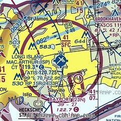
|
CAUTION: Diagram may not be current
 Download PDF
of official airport diagram from the FAA
| Airport distance calculator |
|---|
|
|
| Sunrise and sunset |
|---|
|
Times for 09-May-2026
| | Local
(UTC-4) | | Zulu
(UTC) |
|---|
| Morning civil twilight | | 05:12 | | 09:12 |
| Sunrise | | 05:42 | | 09:42 |
| Sunset | | 19:55 | | 23:55 |
| Evening civil twilight | | 20:26 | | 00:26 |
|
| Current date and time |
|---|
| Zulu (UTC) | 09-May-2026 13:50:32 |
|---|
| Local (UTC-4) | 09-May-2026 09:50:32 |
|---|
|
| METAR |
|---|
| KISP | 091256Z 22008KT 10SM SCT075 OVC090 13/09 A2992 RMK SLP130 T01330089
|
KHWV
11nm E | 091256Z AUTO 21008KT 10SM OVC090 13/08 A2993 RMK AO2 SLP135 T01330083 PWINO
|
KFRG
15nm W | 091253Z 19005KT 10SM FEW060 SCT075 OVC095 13/09 A2992 RMK AO2 RAB15E43 SLP130 P0000 T01280094
|
|
| TAF |
|---|
| KISP | 091128Z 0912/1012 17006KT P6SM SCT040 OVC070 FM091400 21012G18KT P6SM SCT030 BKN040 OVC060 TEMPO 0915/0918 6SM -SHRA BKN030 FM091800 21015G21KT 5SM -SHRA SCT015 BKN025 OVC040 PROB30 0918/0923 2SM TSRA BKN015CB FM092300 19010KT 4SM -SHRA BR SCT007 OVC015 FM100100 16005KT 1SM BR BKN005 OVC009 PROB30 1006/1012 1/2SM DZ FG VV002
|
|
| NOTAMs |
|---|
NOTAMs are issued by the DoD/FAA and will open in a separate window not controlled by AirNav.
|
|


