FAA INFORMATION EFFECTIVE 09 JULY 2026
Location
| FAA Identifier: | FAF |
| Lat/Long: | 37-07-57.3926N 076-36-32.1684W
37-07.956543N 076-36.536140W
37.1326091,-76.6089357
(estimated) |
| Elevation: | 11.6 ft. / 4 m (estimated) |
| Variation: | 11W (2005) |
| Time zone: | UTC -4 (UTC -5 during Standard Time) |
| Zip code: | 23604 |
Airport Operations
| Airport use: | Private use. Permission required prior to landing |
| Control tower: | yes |
| ARTCC: | WASHINGTON CENTER |
| FSS: | LEESBURG FLIGHT SERVICE STATION |
| NOTAMs facility: | DCA (NOTAM-D service available) |
| Attendance: | MON-FRI 1145-0400Z++, EXP FEDERAL HOL |
| Segmented circle: | no |
| Lights: | ACTVT ODALS RWY 14; PAPI RWY 14 & 32; HIRL RWY 14/32 - CTAF. |
| Beacon: | white-white-green (lighted military airport)
Operates sunset to sunrise. |
Airport Communications
| CTAF: | 126.3 |
| FELKER GROUND: | 121.35 229.4 [1200-0400Z++ MON-FRI EXC FEDERAL HOL.] |
| FELKER TOWER: | 126.3 269.25 [1200-0400Z++ MON-FRI EXC FEDERAL HOL.] |
| NORFOLK APPROACH: | 125.7 |
| NORFOLK DEPARTURE: | 125.7 |
| ADZY: | 38.4FM |
| BASE OPS: | 134.1 |
| EMERG: | 121.5 243.0 |
| KOHLS STAR: | 118.9 |
| OPS: | 142.2 255.7 38.7FM 40.35 |
| PMSV METRO: | 134.1 |
| WX ASOS at PHF (6 nm E): | PHONE 757-874-3682 |
| WX AWOS-3 at JGG (8 nm NW): | 120.625 (757-220-8810) |
- MNT 1000-0400Z++ MON-FRI EXC HOL. MAX RNG 30 NM.
Nearby radio navigation aids
| VOR radial/distance | | VOR name | | Freq | | Var |
|---|
| HCMr173/19.6 | | HARCUM VORTAC | | 108.80 | | 07W |
| ORFr313/24.3 | | NORFOLK VORTAC | | 116.90 | | 07W |
| HPWr122/26.9 | | HOPEWELL VORTAC | | 114.35 | | 06W |
| NDB name | | Hdg/Dist | | Freq | | Var | | ID |
|---|
| WAKEFIELD | | 075/20.8 | | 274 | | 11W | | AKQ | .- -.- --.- |
Airport Services
Runway Information
Runway 14/32
| Dimensions: | 3025 x 75 ft. / 922 x 23 m |
| Surface: | asphalt, in fair condition |
| Weight bearing capacity: | |
| Runway edge lights: | high intensity |
| RUNWAY 14 | | RUNWAY 32 |
| Latitude: | 37-08.111333N | | 37-07.801667N |
| Longitude: | 076-36.780167W | | 076-36.292167W |
| Elevation: | 10.0 ft. | | 9.0 ft. |
| Traffic pattern: | right | | left |
| Markings: | nonprecision, in good condition | | nonprecision, in good condition |
| Visual slope indicator: | 2-light PAPI on left (3.00 degrees glide path) | | 2-light PAPI on left (3.00 degrees glide path)
UNUSBL BYD 9 DEGREES RIGHT AND 7 DEGREES LEFT OF CTRLN. |
| Approach lights: | ODALS: omnidirectional approach lighting system
ODALS RY 14 CONTROLLED BY ATCT. | | |
| Touchdown point: | yes, no lights | | yes, no lights |
Helipad H1
| Dimensions: | 100 x 100 ft. / 30 x 30 m |
| Surface: | asphalt, in fair condition |
| Runway edge lights: | PERI |
| Latitude: | 37-08.273000N | | |
| Longitude: | 076-36.291333W | | |
| Elevation: | 5.9 ft. | | |
| Traffic pattern: | left | | left |
Airport Ownership and Management from official FAA records
| Ownership: | U.S. Army |
| Owner: | US ARMY ATCA-ASO
CAMERON STA
ALEXANDRIA, VA 22314 |
| Manager: | USAR OPS
Phone 757-878-2865
X225. |
Additional Remarks
| - | REMOTE BRIEFING AVBL FR SHAW AFB DSN 965-0939/40/41, (FAX) DSN 965-0527. USE C877-297-4129 IF DSN NOT AVBL. |
| - | MISC: FRANGIBLE PERIMETER FENCE ENCLOSING RWY ENVIRONMENT EXISTS WITHIN 500 FT OF RWY CNTRLN. MULTIPLE BLDGS. PENETRATING 7:1 IMAGINARY SURFACE, NE SIDE OF RY. PARKING LOTS/LGT POLES/AND MULTIPLE FRANGIBLE OBJECTS W/IN 500 FT NE OR RY CNTLNE. EMERG DISPATCH MONITORS CTAF, 2300-0700Z++. |
| - | EMERGENCY SERVICES MONITORS CTAF AFTER HOURS. |
| - | AFTER HOUR OPS RESTRICTED TO DOD, STATE/FED MSN ESSENTIAL OPS ONLY. |
| - | FOR CD WHEN ATCT CLSD, CTC NORFOLK APCH AT C757-363-5864. |
| - | REMARKS: CLASS D AIRSPACE EFF 1200-0400Z++ MON-FRI EXEC HOL. OT CLASS G. EMERG DISPATCH MNT CTAF AFT HR. |
| - | FUEL: A SVC AVBL 1200-2130Z++ MON - FRI EXC HOL. |
| - | REMARKS: BASE OPS 1145-0400Z++ MON-FRI EXC HOL, DSN 826-5828/2584, C757-878-5828/2584. |
| - | RSTD: PPR 24 HR NOTICE ALL NON KFAF BASED ACFT, CTC BASE OPS. ACFT ENTERING FR SSE MAX ALT 500 FT DUE TO INST APCH INTO NEWPORT NEWS/WSMBG ARPT. NO HAZARD CARGO AREA AVBL. |
| - | CAUTION: CTC BASOPS FOR CURRENT BASH COND. INCRD BIRD ACTVTY 1 OCT TO 30 NOV AND 1 FEB TO 31 MAR. SGFNT EAGLE ACTVTY IN VCNTY OF 1 NM S APCH END RWY 32, 1 NM E OF ARPT ON WARWICK RIVER.NO ACFT OTFC OF MAIN POST. PERM MOVBL CRANE ON WATERCRAFT BASE 3100 FT WNW OF RWY 14 APCH END. NO FLY AREA 1.6 NM SE RWY 32 TO INCL ENTR PEN. |
| - | TFC PAT; F/W 1000 FT, RGT TFC RY 14. R/W 500 FT. |
| - | MISC: WX FCST ON DUTY 1000-0400Z++ MON-FRI EXC HOL, C757-878-5300, DSN 826-5300. REMOTE BRIEFING AVBL FR SHAW AFB DSN 965-0588, (FAX) DSN 965-1527. USE C877-297-4129 IF DSN NOT AVBL. FLIGHT SERVICES 1-800-WX-BRIEF. WX OBSN VIS RSTD TO 1/2 SM FR NW TO NE; 1/4 TO 3/4 SM ALL OTHER QUAD. WHEN TWR AND/OR SFC VIS IS BLW 4 SM AND DIFFER BY A REPORTABLE VALUE, A TWR VIS RMK WILL BE RPT DUR SUPPLEMENTED WX OBSN. |
Instrument Procedures
NOTE: All procedures below are presented as PDF files. If you need a reader for these files, you should download the free Adobe Reader.NOT FOR NAVIGATION. Please procure official charts for flight.
FAA instrument procedures published for use from 09 July 2026 at 0901Z to 06 August 2026 at 0900Z.
STARs - Standard Terminal Arrivals |
|---|
| KOHLS ONE (RNAV) **NEW** | |
download (178KB) |
IAPs - Instrument Approach Procedures |
|---|
| RNAV (GPS) RWY 14 | |
download (135KB) |
| COPTER RNAV (GPS) RWY 14 | |
download (125KB) |
| NOTE: Special Alternate Minimums apply | |
download (167KB) |
Other nearby airports with instrument procedures:
KPHF - Newport News/Williamsburg International Airport (6 nm E)
KJGG - Waltrip Williamsburg Executive Airport (8 nm NW)
W94 - Camp Peary Landing Strip Airport (11 nm N)
KLFI - Langley Air Force Base (12 nm E)
KNHU - Norfolk Naval Station Airport (18 nm SE)
KNGU - Norfolk Naval Station (Chambers Field) (19 nm SE)
|
|

Road maps at:
MapQuest
Bing
Google
| Aerial photo |
|---|
WARNING: Photo may not be current or correct
 Photo by David Newcomer
Photo taken 10-Sep-2019
looking southeast from 5,000'.
Photo by David Newcomer
Photo taken 10-Sep-2019
looking southeast from 5,000'.
Do you have a better or more recent aerial photo of Felker Army Airfield that you would like to share? If so, please send us your photo.
|
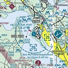
| Sectional chart |
|---|
|
| Airport distance calculator |
|---|
|
|
| Sunrise and sunset |
|---|
|
Times for 12-Jul-2026
| | Local
(UTC-4) | | Zulu
(UTC) |
|---|
| Morning civil twilight | | 05:27 | | 09:27 |
| Sunrise | | 05:57 | | 09:57 |
| Sunset | | 20:27 | | 00:27 |
| Evening civil twilight | | 20:57 | | 00:57 |
|
| Current date and time |
|---|
| Zulu (UTC) | 12-Jul-2026 10:41:35 |
|---|
| Local (UTC-4) | 12-Jul-2026 06:41:35 |
|---|
|
| METAR |
|---|
| KFAF | 120955Z AUTO 09007KT 10SM SCT055 25/22 A3000 RMK AO2 SLP162 T02470216 $
|
KPHF
5nm E | 120954Z 00000KT 7SM FEW039 SCT060 OVC120 23/22 A3001 RMK AO2 SLP162 T02280217
|
KJGG
8nm NW | 121015Z AUTO 00000KT 9SM SCT013 BKN049 OVC130 24/24 A3001 RMK AO2 T02390237
|
KLFI
12nm E | 120955Z AUTO 03010KT 10SM FEW039 SCT048 BKN060 OVC120 24/21 A2999 RMK AO2 SLP162 T02390214 $
|
|
| TAF |
|---|
KPHF
5nm E | 120541Z 1206/1306 VRB02KT P6SM VCTS OVC030CB FM120800 04004KT 5SM -SHRA BR OVC025 FM121500 08010KT 5SM -SHRA BR OVC025 PROB30 1215/1220 VRB15G30KT 4SM TSRA OVC025CB FM122200 09009KT P6SM OVC035
|
|
| NOTAMs |
|---|
NOTAMs are issued by the DoD/FAA and will open in a separate window not controlled by AirNav.
|
|

