FAA INFORMATION EFFECTIVE 16 APRIL 2026
Location
| FAA Identifier: | ARB |
| Lat/Long: | 42-13-22.5392N 083-44-44.5518W
42-13.375653N 083-44.742530W
42.2229276,-83.7457088
(estimated) |
| Elevation: | 839 ft. / 256 m (estimated) |
| Variation: | 05W (1985) |
| From city: | 3 miles S of ANN ARBOR, MI |
| Time zone: | UTC -4 (UTC -5 during Standard Time) |
| Zip code: | 48108 |
Airport Operations
| Airport use: | Open to the public |
| Activation date: | 04/1940 |
| Control tower: | yes |
| ARTCC: | CLEVELAND CENTER |
| FSS: | LANSING FLIGHT SERVICE STATION |
| NOTAMs facility: | ARB (NOTAM-D service available) |
| Attendance: | APR-OCT 0800-2000, NOV-MAR 0800-1800
TRML OPEN 0700-DUSK. |
| Wind indicator: | lighted |
| Segmented circle: | yes |
| Lights: | WHEN ATCT CLSD ACTVT REIL RWY 06; PAPI RWY 06; VASI RWY 24; MIRL RWY 06/24 - CTAF. |
| Beacon: | white-green (lighted land airport)
Operates sunset to sunrise. |
Airport Communications
| CTAF: | 120.3 |
| UNICOM: | 123.0 |
| ATIS: | 134.55 |
| WX ASOS: | PHONE 734-668-7173 |
| ANN ARBOR GROUND: | 121.6 [0800-2000] |
| ANN ARBOR TOWER: | 120.3 [0800-2000] |
| DETROIT APPROACH: | 118.95 |
| DETROIT DEPARTURE: | 118.95 |
| CLEARANCE DELIVERY: | 121.6 |
| EMERG: | 121.5 |
| METRO DP: | 118.95 ;WESTBOUND 134.3 ;EASTBOUND |
| WX ASOS at YIP (10 nm E): | PHONE 734-961-6843 |
| WX ASOS at DTW (17 nm E): | PHONE 231-202-2054 |
Nearby radio navigation aids
| VOR radial/distance | | VOR name | | Freq | | Var |
|---|
| SVMr214/13.0 | | SALEM VORTAC | | 114.30 | | 03W |
| CRLr312/16.6 | | CARLETON VOR/DME | | 115.70 | | 03W |
| DXOr278/16.9 | | DETROIT VOR/DME | | 113.40 | | 06W |
| NDB name | | Hdg/Dist | | Freq | | Var | | ID |
|---|
| ADRIAN | | 041/25.8 | | 278 | | 06W | | ADG | .- -.. --. |
Airport Services
| Fuel available: | 100LL JET-A+ |
| Parking: | hangars and tiedowns |
| Airframe service: | MAJOR |
| Powerplant service: | MAJOR |
| Bottled oxygen: | HIGH/LOW |
| Bulk oxygen: | HIGH/LOW |
Runway Information
Runway 6/24
| Dimensions: | 3505 x 75 ft. / 1068 x 23 m |
| Surface: | concrete/grooved, in fair condition |
| Weight bearing capacity: | | Single wheel: | 45.0 | | Double wheel: | 70.0 |
|
| Runway edge lights: | medium intensity |
| RUNWAY 6 | | RUNWAY 24 |
| Latitude: | 42-13.214628N | | 42-13.549472N |
| Longitude: | 083-45.006382W | | 083-44.374113W |
| Elevation: | 831.3 ft. | | 826.0 ft. |
| Traffic pattern: | left | | left |
| Runway heading: | 060 magnetic, 055 true | | 240 magnetic, 235 true |
| Markings: | nonprecision, in good condition | | nonprecision, in good condition |
| Visual slope indicator: | 4-light PAPI on left (3.00 degrees glide path) | | 2-box VASI on left (3.00 degrees glide path) |
| Runway end identifier lights: | yes | | |
| Touchdown point: | yes, no lights | | yes, no lights |
| Obstructions: | none | | 74 ft. tree, 1090 ft. from runway, 389 ft. right of centerline, 12:1 slope to clear |
Runway 12/30
| Dimensions: | 2750 x 110 ft. / 838 x 34 m |
| Surface: | turf, in fair condition |
| Runway edge markings: | 3 FT YELLOW CONES. |
| RUNWAY 12 | | RUNWAY 30 |
| Latitude: | 42-13.488333N | | 42-13.246667N |
| Longitude: | 083-45.066667W | | 083-44.551667W |
| Elevation: | 839.0 ft. | | 822.0 ft. |
| Traffic pattern: | left | | left |
| Runway heading: | 127 magnetic, 122 true | | 307 magnetic, 302 true |
| Runway end identifier lights: | no | | no |
| Touchdown point: | yes, no lights | | yes, no lights |
| Obstructions: | none | | 83 ft. tree, 1241 ft. from runway, 255 ft. right of centerline, 14:1 slope to clear |
Airport Ownership and Management from official FAA records
| Ownership: | Publicly-owned |
| Owner: | CITY OF ANN ARBOR
PO BOX 8647
ANN ARBOR, MI 48107-8647
Phone 734-794-6312 |
| Manager: | CARL KONOPASKA
801 AIRPORT DR
ANN ARBOR, MI 48108-9703
Phone 734-794-6312 |
Additional Remarks
| - | DEER & LRG BIRDS ON & INVOF ARPT. |
| - | WHEN ATCT CLSD CONFIRM SNOW REMOVAL OPNS & WINTER CONDS - CTAF. |
| - | RWY 24 RUNUP AREA FIRST 200 FT OF TWY A; TWY A1 BTN TWY A & RWY 24 HOLD LINE NOT VSB FM TWR. |
| - | FOR CD WHEN ATCT IS CLSD CTC DETROIT APCH AT 734-955-1404. |
| - | NO SNOW REMOVAL FOR RWY 12/30. |
Instrument Procedures
NOTE: All procedures below are presented as PDF files. If you need a reader for these files, you should download the free Adobe Reader.NOT FOR NAVIGATION. Please procure official charts for flight.
FAA instrument procedures published for use from 16 April 2026 at 0901Z to 14 May 2026 at 0900Z.
STARs - Standard Terminal Arrivals |
|---|
| FOREY TWO (RNAV) | |
download (160KB) |
| OKLND ONE (RNAV) | |
download (145KB) |
| PETTE TWO (RNAV) | |
download (210KB) |
| RRALF THREE (RNAV) | |
download (161KB) |
IAPs - Instrument Approach Procedures |
|---|
| RNAV (GPS) RWY 06 | |
download (225KB) |
| RNAV (GPS) RWY 24 | |
download (222KB) |
| VOR RWY 06 | |
download (225KB) |
| VOR RWY 24 | |
download (238KB) |
| NOTE: Special Alternate Minimums apply | |
download (139KB) |
Departure Procedures |
|---|
| BARII THREE (RNAV) | |
download (156KB) |
| CCOBB THREE (RNAV) | |
download (193KB) |
| CLVIN THREE (RNAV) | |
download (175KB) |
| HHOWE FOUR (RNAV) | |
download (180KB) |
| KAYLN THREE (RNAV) | |
download (161KB) |
| KZLOV TWO (RNAV) | |
download (152KB) |
| LIDDS FOUR (RNAV) | |
download (179KB) |
| METRO FOUR | |
2 pages:
[1] [2] (362KB) |
| MIGGY THREE (RNAV) | |
download (193KB) |
| PAVYL THREE (RNAV) | |
download (169KB) |
| SNDRS THREE (RNAV) | |
download (208KB) |
| TRMML FOUR (RNAV) | |
download (161KB) |
| ZETTR FOUR (RNAV) | |
download (202KB) |
| NOTE: Special Take-Off Minimums/Departure Procedures apply | |
download (208KB) |
Other nearby airports with instrument procedures:
KYIP - Willow Run Airport (10 nm E)
1D2 - Canton-Plymouth-Mettetal Airport (15 nm NE)
KDTW - Detroit Metro Wayne County Airport (17 nm E)
Y47 - Oakland Southwest Airport (18 nm N)
KTTF - Custer Airport (22 nm SE)
|
|

Road maps at:
MapQuest
Bing
Google
| Aerial photo |
|---|
WARNING: Photo may not be current or correct
 Photo by Andrew Thompson.
Photo taken 27-Jun-2009
Photo by Andrew Thompson.
Photo taken 27-Jun-2009
Do you have a better or more recent aerial photo of Ann Arbor Municipal Airport that you would like to share? If so, please send us your photo.
|
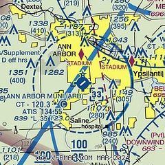
| Sectional chart |
|---|
|
CAUTION: Diagram may not be current
 Download PDF
of official airport diagram from the FAA
| Airport distance calculator |
|---|
|
|
| Sunrise and sunset |
|---|
|
Times for 17-Apr-2026
| | Local
(UTC-4) | | Zulu
(UTC) |
|---|
| Morning civil twilight | | 06:23 | | 10:23 |
| Sunrise | | 06:52 | | 10:52 |
| Sunset | | 20:17 | | 00:17 |
| Evening civil twilight | | 20:46 | | 00:46 |
|
| Current date and time |
|---|
| Zulu (UTC) | 18-Apr-2026 01:21:46 |
|---|
| Local (UTC-4) | 17-Apr-2026 21:21:46 |
|---|
|
| METAR |
|---|
| KARB | 734-668-7173
180053Z 12005KT 10SM CLR 15/11 A2985 RMK AO2 SLP108 T01500111
|
KYIP
9nm E | 180053Z 14006KT 10SM CLR 14/09 A2987 RMK AO2 SLP112 T01390094
|
KDTW
18nm E | 180053Z 15004KT 10SM SCT180 OVC220 16/11 A2987 RMK AO2 PRESRR SLP115 T01560106
|
|
| TAF |
|---|
KYIP
9nm E | 171722Z 1718/1818 14007KT P6SM BKN008 FM171830 17009KT P6SM SCT250 FM180500 18012G20KT P6SM OVC050 WS020/20045KT TEMPO 1807/1810 2SM -TSRA OVC020CB FM181600 28012G23KT P6SM VCSH BKN025 OVC050
|
KDTW
18nm E | 172107Z 1721/1824 17009KT P6SM SCT250 FM180500 18012G20KT P6SM -SHRA OVC050 WS020/20045KT TEMPO 1807/1810 2SM -TSRA OVC020CB FM181600 28012G23KT P6SM VCSH BKN025 OVC050
|
|
| NOTAMs |
|---|
NOTAMs are issued by the DoD/FAA and will open in a separate window not controlled by AirNav.
|
|


