FAA INFORMATION EFFECTIVE 14 MAY 2026
Location
| FAA Identifier: | DTW |
| Lat/Long: | 42-12-44.7520N 083-21-12.2160W
42-12.745867N 083-21.203600W
42.2124311,-83.3533933
(estimated) |
| Elevation: | 645.2 ft. / 196.7 m (surveyed) |
| Variation: | 07W (2020) |
| From city: | 15 miles S of DETROIT, MI |
| Time zone: | UTC -4 (UTC -5 during Standard Time) |
| Zip code: | 48174 |
Airport Operations
| Airport use: | Open to the public |
| Activation date: | 04/1940 |
| Control tower: | yes |
| ARTCC: | CLEVELAND CENTER |
| FSS: | LANSING FLIGHT SERVICE STATION |
| NOTAMs facility: | DTW (NOTAM-D service available) |
| Attendance: | CONTINUOUS |
| Wind indicator: | lighted |
| Segmented circle: | no |
| Beacon: | white-green (lighted land airport)
Operates sunset to sunrise. |
| Landing fee: | yes |
| Fire and rescue: | ARFF index E |
| International operations: | international airport of entry |
Airport Communications
| UNICOM: | 122.95 |
| WX ASOS: | PHONE 231-202-2054 |
| METRO GROUND: | 119.25 ;SOUTHEAST 119.45 ;NORTHEAST 121.8 ;NORTHWEST 132.725 ;SOUTHWEST |
| METRO TOWER: | 118.4 ;ARRIVAL RWY 03R/21L, 27R 118.4 ;DEP, ARPT DIAG RWY 03L/21R, 0 128.125 ;ARRIVAL RWY 04R/22L 128.75 ;ARRIVAL RWY 03L/21R, 27L 128.75 ;DEP, ARPT DIAG RWY 27L 135.0 ;ARRIVAL RWY 04L/22R 135.0 ;DEP, ARPT DIAG RWY 04L/22R, 0 317.725 |
| DETROIT APPROACH: | 124.05 ;RWY 04L/22R, 04R/22L, 27L 125.15 ;RWY 03R, 21L, 27R |
| DETROIT DEPARTURE: | 118.95 ;PROPS/TURBOPROPS-WEST 125.525 ;TURBOJETS-WEST 132.025 ;TURBOJETS-EAST 134.3 ;PROPS/TURBOPROPS-EAST |
| CLEARANCE DELIVERY: | 120.65 |
| PRE-TAXI CLEARANCE: | 120.65 |
| BARII DP: | 125.525 ;RWY 04L/22R, 04R/22L 132.025 ;RWY 03L/21R, 03R/21L, 27L, |
| BONZZ STAR: | 126.225 |
| CCOBB DP: | 125.525 ;RWY 03L, 03R, 04L, 04R, 21L 132.025 ;RWY 27L, 27R |
| CLASS B: | 118.95 ;SW 132.35 ;NW/NE 134.3 ;SE |
| CLVIN DP: | 125.525 ;RWY 04L/22R, 04R/22L 132.025 ;RWY 03L/21R, 03R/21L, 27L, |
| CRAKN STAR: | 126.225 |
| CUUGR STAR: | 126.225 |
| D-ATIS: | 118.125 ;DEP 133.675 ;ARR |
| EMERG: | 121.5 243.0 |
| FERRL STAR: | 126.225 |
| GRAYT STAR: | 124.975 |
| HANBL STAR: | 124.975 |
| HAYLL STAR: | 124.975 |
| HHOWE DP: | 125.525 ;RWY 27L, 27R 132.025 ;RWY 03L/21R, 03R/21L, 04L/2 |
| HTROD STAR: | 126.225 |
| KAYLN DP: | 125.525 |
| KKISS STAR: | 124.975 |
| KLYNK STAR: | 126.225 |
| KZLOV DP: | 132.025 |
| LAYKS STAR: | 124.975 |
| LECTR STAR: | 124.975 |
| LIDDS DP: | 132.025 |
| MEDEVAC: | 259.6 |
| METRO DP: | 118.95 ;WESTBOUND 134.3 ;EASTBOUND |
| MIGGY DP: | 125.525 |
| PAVYL DP: | 132.025 |
| PRM: | 127.05 ;RWY 04L/22R 135.775 ;RWY 04R/22L |
| RKCTY STAR: | 124.975 |
| SNDRS DP: | 125.525 ;RWY 04L/22R, 04R/22L 132.025 ;RWY 03L/21R, 03R/21L, 27L, |
| TPGUN STAR: | 126.225 |
| TRMML DP: | 125.525 ;RWY 22L, 22R, 27L, 27R 132.025 ;RWY 03L, 03R, 04L, 04R, 21L |
| VCTRZ STAR: | 124.975 |
| WNGNT STAR: | 126.225 |
| ZETTR DP: | 125.525 ;RWY 22L, 22R, 27L, 27R 132.025 ;RWY 03L, 03R, 04L, 04R, 21L |
| WX ASOS at YIP (8 nm W): | PHONE 734-961-6843 |
| WX AWOS-3P at ONZ (11 nm SE): | 119.675 (734-692-9686) |
| WX AWOS-3P at TTF (17 nm S): | 119.075 (734-384-0259) |
| WX ASOS at ARB (17 nm W): | PHONE 734-668-7173 |
| WX ASOS at DET (19 nm NE): | PHONE 313-371-9696 |
- ASDE-X IN USE. OPERATE TRANSPONDERS WITH ALTITUDE REPORTING MODE AND ADS-B (IF EQUIPPED) ENABLED ON ALL AIRPORT SURFACES.
Nearby radio navigation aids
| VOR radial/distance | | VOR name | | Freq | | Var |
|---|
| DXO at field | | DETROIT VOR/DME | | 113.40 | | 06W |
| CRLr028/10.9 | | CARLETON VOR/DME | | 115.70 | | 03W |
| SVMr141/15.9 | | SALEM VORTAC | | 114.30 | | 03W |
| NDB name | | Hdg/Dist | | Freq | | Var | | ID |
|---|
| ADRIAN | | 064/38.3 | | 278 | | 06W | | ADG | .- -.. --. |
Airport Services
| Fuel available: | 100LL JET-A |
| Parking: | hangars and tiedowns |
| Airframe service: | NONE |
| Powerplant service: | NONE |
| Bottled oxygen: | NONE |
| Bulk oxygen: | NONE |
Runway Information
Runway 4R/22L
| Dimensions: | 12003 x 200 ft. / 3659 x 61 m |
| Surface: | concrete/grooved, in excellent condition |
| Weight bearing capacity: | | Single wheel: | 100.0 | | Double wheel: | 185.0 | | Double tandem: | 350.0 |
|
| Runway edge lights: | high intensity |
| RUNWAY 4R | | RUNWAY 22L |
| Latitude: | 42-12.139427N | | 42-13.872740N |
| Longitude: | 083-22.276162W | | 083-20.999425W |
| Elevation: | 637.0 ft. | | 635.8 ft. |
| Traffic pattern: | left | | left |
| Runway heading: | 036 magnetic, 029 true | | 216 magnetic, 209 true |
| Displaced threshold: | 509 ft. | | no |
| Declared distances: | TORA:12003 TODA:12003 ASDA:12003 LDA:11494 | | TORA:12003 TODA:12003 ASDA:12003 LDA:12003 |
| Markings: | precision, in good condition | | precision, in good condition |
| RVR equipment: | touchdown, midfield, rollout | | touchdown, midfield, rollout |
| Approach lights: | ALSF2: standard 2,400 foot high intensity approach lighting system with centerline sequenced flashers (category II or III)
ALSO HAS SSALR. | | MALSR: 1,400 foot medium intensity approach lighting system with runway alignment indicator lights |
| Runway end identifier lights: | | | no |
| Centerline lights: | yes | | yes |
| Touchdown point: | yes, lighted | | yes, no lights |
| Instrument approach: | ILS/DME | | ILS/DME |
| Obstructions: | 85 ft. tree, 3652 ft. from runway, 852 ft. right of centerline, 41:1 slope to clear | | 24 ft. rr, 1271 ft. from runway, 616 ft. left of centerline, 43:1 slope to clear |
Runway 3R/21L
| Dimensions: | 10001 x 150 ft. / 3048 x 46 m |
| Surface: | concrete/grooved, in excellent condition |
| Weight bearing capacity: | | Single wheel: | 100.0 | | Double wheel: | 200.0 | | Double tandem: | 350.0 | | Dual double tandem: | 750.0 |
|
| Runway edge lights: | high intensity |
| RUNWAY 3R | | RUNWAY 21L |
| Latitude: | 42-11.736858N | | 42-13.180920N |
| Longitude: | 083-21.108113W | | 083-20.044195W |
| Elevation: | 632.8 ft. | | 631.8 ft. |
| Traffic pattern: | left | | left |
| Runway heading: | 036 magnetic, 029 true | | 216 magnetic, 209 true |
| Declared distances: | TORA:10001 TODA:10001 ASDA:10001 LDA:10001 | | TORA:10001 TODA:10001 ASDA:10001 LDA:10001 |
| Markings: | precision, in good condition | | precision, in good condition |
| Visual slope indicator: | 4-light PAPI on right (3.00 degrees glide path) | | 4-light PAPI on left (3.00 degrees glide path) |
| RVR equipment: | touchdown, midfield, rollout | | touchdown, midfield, rollout |
| Approach lights: | ALSF2: standard 2,400 foot high intensity approach lighting system with centerline sequenced flashers (category II or III)
ALSF2 RQRD WHEN RVR/VSBLY IS 6000/1 MILE OR LESS. SSALR OPERD WHEN RVR/VSBLY IS 6000/1 MILE. | | MALSR: 1,400 foot medium intensity approach lighting system with runway alignment indicator lights |
| Runway end identifier lights: | no | | no |
| Centerline lights: | yes | | yes |
| Touchdown point: | yes, lighted | | yes, no lights |
| Instrument approach: | ILS/DME | | ILS/DME |
| Obstructions: | 22 ft. road, 1119 ft. from runway, 439 ft. left of centerline, 41:1 slope to clear | | 20 ft. berm, 559 ft. from runway, 523 ft. right of centerline, 17:1 slope to clear |
Runway 4L/22R
| Dimensions: | 10000 x 150 ft. / 3048 x 46 m |
| Surface: | concrete/grooved, in excellent condition |
| Weight bearing capacity: | | Single wheel: | 100.0 | | Double wheel: | 200.0 | | Double tandem: | 350.0 | | Dual double tandem: | 750.0 |
|
| Runway edge lights: | high intensity |
| RUNWAY 4L | | RUNWAY 22R |
| Latitude: | 42-12.130360N | | 42-13.574702N |
| Longitude: | 083-23.040005W | | 083-21.976858W |
| Elevation: | 645.2 ft. | | 642.1 ft. |
| Traffic pattern: | left | | left |
| Runway heading: | 036 magnetic, 029 true | | 216 magnetic, 209 true |
| Declared distances: | TORA:10000 TODA:10000 ASDA:10000 LDA:10000 | | TORA:10000 TODA:10000 ASDA:10000 LDA:10000 |
| Markings: | precision, in good condition | | precision, in good condition |
| Visual slope indicator: | 4-light PAPI on left (3.00 degrees glide path) | | 4-light PAPI on right (3.00 degrees glide path) |
| RVR equipment: | touchdown, midfield, rollout | | touchdown, midfield, rollout |
| Approach lights: | ALSF2: standard 2,400 foot high intensity approach lighting system with centerline sequenced flashers (category II or III) | | MALSR: 1,400 foot medium intensity approach lighting system with runway alignment indicator lights |
| Runway end identifier lights: | no | | no |
| Centerline lights: | yes | | yes |
| Touchdown point: | yes, lighted | | yes, lighted |
| Instrument approach: | ILS/DME | | ILS/DME |
| Obstructions: | 48 ft. tree, 2563 ft. from runway, 157 ft. right of centerline, 49:1 slope to clear | | 14 ft. road, 550 ft. from runway, 545 ft. right of centerline, 25:1 slope to clear |
Runway 9L/27R
| Dimensions: | 8708 x 150 ft. / 2654 x 46 m |
| Surface: | concrete/grooved, in excellent condition |
| Weight bearing capacity: | | Single wheel: | 100.0 | | Double wheel: | 185.0 | | Double tandem: | 350.0 |
|
| Runway edge lights: | high intensity |
| RUNWAY 9L | | RUNWAY 27R |
| Latitude: | 42-13.018035N | | 42-13.050365N |
| Longitude: | 083-21.790073W | | 083-19.861910W |
| Elevation: | 638.0 ft. | | 634.3 ft. |
| Traffic pattern: | left | | left |
| Runway heading: | 096 magnetic, 089 true | | 276 magnetic, 269 true |
| Declared distances: | TORA:8708 TODA:8708 ASDA:8618 LDA:8618 | | TORA:8708 TODA:8708 ASDA:8708 LDA:8708 |
| Markings: | precision, in good condition | | precision, in good condition |
| Visual slope indicator: | | | 4-light PAPI on left (3.00 degrees glide path) |
| RVR equipment: | rollout | | touchdown |
| Approach lights: | | | MALSR: 1,400 foot medium intensity approach lighting system with runway alignment indicator lights |
| Runway end identifier lights: | yes | | no |
| Touchdown point: | yes, no lights | | yes, no lights |
| Instrument approach: | | | ILS |
| Obstructions: | 107 ft. ant, 4461 ft. from runway, 461 ft. right of centerline, 40:1 slope to clear | | 7 ft. berm, 333 ft. from runway, 373 ft. right of centerline, 19:1 slope to clear |
Runway 3L/21R
| Dimensions: | 8501 x 150 ft. / 2591 x 46 m |
| Surface: | concrete/grooved, in excellent condition |
| Weight bearing capacity: | | Single wheel: | 120.0 | | Double wheel: | 250.0 | | Double tandem: | 550.0 | | Dual double tandem: | 1000.0 |
|
| Runway edge lights: | high intensity |
| RUNWAY 3L | | RUNWAY 21R |
| Latitude: | 42-12.470135N | | 42-13.697643N |
| Longitude: | 083-21.073135W | | 083-20.168450W |
| Elevation: | 636.5 ft. | | 631.4 ft. |
| Traffic pattern: | left | | left |
| Runway heading: | 036 magnetic, 029 true | | 216 magnetic, 209 true |
| Declared distances: | TORA:8501 TODA:8501 ASDA:8501 LDA:8501 | | TORA:8501 TODA:8501 ASDA:8501 LDA:8501 |
| Markings: | nonprecision, in good condition | | nonprecision, in good condition |
| Visual slope indicator: | 4-light PAPI on right (3.00 degrees glide path)
PAPI UNUSBL BYD 8 DEGS LEFT OR RIGHT OF CNTRLN. | | 4-light PAPI on left (3.00 degrees glide path) |
| RVR equipment: | touchdown, rollout | | touchdown, rollout |
| Runway end identifier lights: | yes | | yes |
| Centerline lights: | yes | | yes |
| Touchdown point: | yes, no lights | | yes, no lights |
| Obstructions: | 19 ft. pole, 698 ft. from runway, 569 ft. left of centerline, 26:1 slope to clear | | 42 ft. pole, 2302 ft. from runway, 179 ft. right of centerline |
Runway 9R/27L
| Dimensions: | 8500 x 150 ft. / 2591 x 46 m |
| Surface: | concrete/grooved, in fair condition |
| Weight bearing capacity: | | Single wheel: | 100.0 | | Double wheel: | 185.0 | | Double tandem: | 350.0 |
|
| Runway edge lights: | high intensity |
| Operational restrictions: | WEST 1713 FT CLSD INDEFLY. |
| RUNWAY 9R | | RUNWAY 27L |
| Latitude: | 42-11.940903N | | 42-11.972287N |
| Longitude: | 083-21.703747W | | 083-19.822127W |
| Elevation: | 636.0 ft. | | 629.0 ft. |
| Traffic pattern: | left | | left |
| Runway heading: | 096 magnetic, 089 true | | 276 magnetic, 269 true |
| Declared distances: | TORA:6787 TODA:6787 ASDA:6787 LDA:6787 | | TORA:6787 TODA:6787 ASDA:6787 LDA:6787 |
| Markings: | precision, in good condition | | precision, in good condition |
| Visual slope indicator: | | | 4-light PAPI on left (3.00 degrees glide path) |
| RVR equipment: | rollout | | touchdown |
| Approach lights: | | | MALSR: 1,400 foot medium intensity approach lighting system with runway alignment indicator lights |
| Runway end identifier lights: | yes | | |
| Centerline lights: | yes | | yes |
| Touchdown point: | yes, no lights | | yes, no lights |
| Instrument approach: | | | ILS/DME |
Airport Ownership and Management from official FAA records
| Ownership: | Publicly-owned |
| Owner: | WAYNE COUNTY, MICHIGAN
11050 ROGELL DR #602
DETROIT, MI 48242-1144
Phone 734-942-3550 |
| Manager: | CHAD NEWTON
11050 ROGELL DR #602
DETROIT, MI 48242-1144
Phone 734-942-3685 |
Additional Remarks
| A30-04X/22X | RY ID 04X/22X SUPPORTS SECOND ILS'S (I-BZB AND I-ALA) AT RY 04L/22R. |
| A39-09R/27L | PCR VALUE: 863/R/A/W/T |
| A39-09L/27R | PCR VALUE: 762/R/A/W/T |
| A39-03R/21L | PCR VALUE: 863/R/A/W/T |
| A39-04R/22L | PCR VALUE: 863/R/A/W/T |
| A39-04L/22R | PCR VALUE: 863/R/A/W/T |
| A39-03L/21R | PCR VALUE: 863/R/A/W/T |
| - | BRIGHTLY LIGHTED PARKING LOT 2.6 NM SW OF ARPT. |
| - | RY STATUS LGTS ARE IN OPN. |
| - | RWY VISUAL SCREEN 20 FT AGL 1150 FT S. AER 04R |
| - | PPR FOR B747-8 OPRS DUE TO CONSTRAINTS ON RWYS, TWYS AND RAMPS CTC AIRFIELD OPRS AT 734-942-3685. |
| - | ACFT WITH WINGSPAN GTR THAN 171 FT ARE RSTRD FM USING TWY P BTN TWY J & TWY P3. |
| - | ACFT WITH WINGSPAN GTR THAN 171 FT ARE RSTRD FM USING TWY H BTN TWY B & TWY F. |
| - | TURNING RSTRD TO WINGSPAN 135 FT OR LESS TWY G NORTH TO TWY V EAST. |
| - | DVRSN ACR ACFT WO A PRESENCE AT DTW SHOULD CTC EVANS RAMP TWR 734-247-1046 PRIOR TO DIVG TO THE EXTENT PRACTICAL & PRVD CO, FLT OPR, CTC INFO, TYP, POB, INTL OR DOM, & ANY GND HANDLER AGRMTS IN PLACE. |
| - | BE ALERT BIRDS, WATERFOWL, ON & INVOF ARPT. |
| - | AIRCRAFT WITH WINGSPAN GREATER THAN 171 FT CANNOT PASS EACH OTHER ON TWYS Y AND K BETWEEN TWYS U AND K6 INSUFFICIENT WINGTIP CLEARANCE. |
| - | TURNING RESTRICTION TWY B TO TWY K RESTRICTED TO AIRCRAFT WITH WINGSPAN 171 FT OR LESS. |
| - | AUTH TO CONDUCT SIMUL INDEPENDENT INSTR APCHS TO PARL RWY 04L/22R & 03R/21L WO FINAL MONITORS, RWY CNTRLNS SEPARATED BY 8800 FT. |
| - | ACFT ON TWY 'F' AND TWY 'V' DO NOT BLOCK FIRE STATION EXITS. |
| - | TAXI ON RWY 09L/27R LTD TO: EXITING FM RWY 04R/22L, 03L/21R, & 03R/21L EXC NO TAXI BTN RWY 03L/21R & TWY W; TWO-WAY TAXI BTN TWY Y & TWY M WHEN RED STOP BAR LGTS ARE LGTD AT RWY 04R/22L & 03L/21R OR WHEN BARRICADES ARE USED INSTEAD AT THE RESPECTIVE INTS. TAXI BTN SS-SR OR IN CONDS WITH VIS LESS THAN 1 SM RQRS GREEN CNTRLN LGT TO BE OPR. |
Instrument Procedures
NOTE: All procedures below are presented as PDF files. If you need a reader for these files, you should download the free Adobe Reader.NOT FOR NAVIGATION. Please procure official charts for flight.
FAA instrument procedures published for use from 14 May 2026 at 0901Z to 11 June 2026 at 0900Z.
STARs - Standard Terminal Arrivals |
|---|
| BONZZ TWO (RNAV) | |
2 pages:
[1] [2] (390KB) |
| CRAKN TWO (RNAV) | |
download (175KB) |
| CUUGR TWO (RNAV) | |
download (272KB) |
| FERRL TWO (RNAV) | |
download (197KB) |
| GRAYT TWO (RNAV) | |
2 pages:
[1] [2] (307KB) |
| HANBL THREE (RNAV) | |
2 pages:
[1] [2] (437KB) |
| HAYLL THREE (RNAV) | |
download (185KB) |
| HTROD TWO (RNAV) | |
download (240KB) |
| KKISS TWO (RNAV) | |
2 pages:
[1] [2] (441KB) |
| KLYNK THREE (RNAV) | |
download (180KB) |
| LAYKS TWO (RNAV) | |
download (182KB) |
| LECTR THREE (RNAV) | |
download (214KB) |
| RKCTY TWO (RNAV) | |
download (216KB) |
| TPGUN TWO (RNAV) | |
download (227KB) |
| VCTRZ TWO (RNAV) | |
2 pages:
[1] [2] (416KB) |
| WNGNT TWO (RNAV) | |
download (227KB) |
IAPs - Instrument Approach Procedures |
|---|
| ILS OR LOC RWY 03R **CHANGED** | |
download (325KB) |
| ILS OR LOC RWY 04R **CHANGED** | |
download (327KB) |
| ILS OR LOC RWY 21L **CHANGED** | |
download (336KB) |
| ILS OR LOC RWY 22L **CHANGED** | |
download (317KB) |
| ILS OR LOC RWY 27L **CHANGED** | |
download (303KB) |
| ILS OR LOC RWY 27R **CHANGED** | |
download (323KB) |
| ILS Z OR LOC RWY 04L **CHANGED** | |
download (358KB) |
| ILS Z OR LOC RWY 22R **CHANGED** | |
download (320KB) |
| ILS Y RWY 04L **CHANGED** | |
download (303KB) |
| ILS Y RWY 22R **CHANGED** | |
download (298KB) |
| ILS RWY 03R (SA CAT I) **CHANGED** | |
download (320KB) |
| ILS RWY 04R (SA CAT I) **CHANGED** | |
download (318KB) |
| ILS RWY 22L (SA CAT I) **CHANGED** | |
download (306KB) |
| ILS RWY 21L (SA CAT I - II) **CHANGED** | |
download (344KB) |
| ILS RWY 27L (SA CAT I - II) **CHANGED** | |
download (300KB) |
| ILS Z RWY 22R (SA CAT I - II) **CHANGED** | |
download (325KB) |
| ILS RWY 03R (CAT II - III) **CHANGED** | |
download (327KB) |
| ILS RWY 04R (CAT II - III) **CHANGED** | |
download (311KB) |
| ILS Z RWY 04L (CAT II - III) **CHANGED** | |
download (329KB) |
| RNAV (RNP) U RWY 04L **CHANGED** | |
download (266KB) |
| RNAV (RNP) U RWY 22R **CHANGED** | |
download (262KB) |
| RNAV (RNP) W RWY 03R **CHANGED** | |
download (236KB) |
| RNAV (RNP) W RWY 04L **CHANGED** | |
download (239KB) |
| RNAV (RNP) W RWY 21L **CHANGED** | |
download (238KB) |
| RNAV (RNP) W RWY 22R **CHANGED** | |
download (231KB) |
| RNAV (RNP) X RWY 03R **CHANGED** | |
download (263KB) |
| RNAV (RNP) X RWY 04L **CHANGED** | |
download (258KB) |
| RNAV (RNP) X RWY 04R **CHANGED** | |
download (272KB) |
| RNAV (RNP) X RWY 21L **CHANGED** | |
download (264KB) |
| RNAV (RNP) X RWY 22L **CHANGED** | |
download (274KB) |
| RNAV (RNP) X RWY 22R **CHANGED** | |
download (254KB) |
| RNAV (GPS) RWY 27L **CHANGED** | |
download (267KB) |
| RNAV (GPS) RWY 27R **CHANGED** | |
download (271KB) |
| RNAV (GPS) Y RWY 04L **CHANGED** | |
download (287KB) |
| RNAV (GPS) Y RWY 22R **CHANGED** | |
download (285KB) |
| RNAV (GPS) Z RWY 03R **CHANGED** | |
download (291KB) |
| RNAV (GPS) Z RWY 04L **CHANGED** | |
download (284KB) |
| RNAV (GPS) Z RWY 04R **CHANGED** | |
download (265KB) |
| RNAV (GPS) Z RWY 21L **CHANGED** | |
download (296KB) |
| RNAV (GPS) Z RWY 22L **CHANGED** | |
download (278KB) |
| RNAV (GPS) Z RWY 22R **CHANGED** | |
download (277KB) |
| PRM AAUP | |
download (267KB) |
| ILS PRM RWY 04R **CHANGED** | |
download (340KB) |
| ILS PRM RWY 22L **CHANGED** | |
download (323KB) |
| ILS PRM Y RWY 04L **CHANGED** | |
download (330KB) |
| ILS PRM Y RWY 22R **CHANGED** | |
download (319KB) |
| ILS PRM Z RWY 04L **CHANGED** | |
download (320KB) |
| ILS PRM Z RWY 22R **CHANGED** | |
download (311KB) |
| ILS PRM RWY 04R (SA CAT I) **CHANGED** | |
download (344KB) |
| ILS PRM Z RWY 22R (SA CAT I - II) **CHANGED** | |
download (345KB) |
| ILS PRM RWY 04R (CAT II - III) **CHANGED** | |
download (339KB) |
| ILS PRM Z RWY 04L (CAT II - III) **CHANGED** | |
download (347KB) |
| RNAV (GPS) PRM Y RWY 04L **CHANGED** | |
download (274KB) |
| RNAV (GPS) PRM Y RWY 22R **CHANGED** | |
download (270KB) |
| RNAV (GPS) PRM Z RWY 04R **CHANGED** | |
download (254KB) |
| RNAV (GPS) PRM Z RWY 22L **CHANGED** | |
download (266KB) |
Departure Procedures |
|---|
| BARII THREE (RNAV) | |
2 pages:
[1] [2] (481KB) |
| CCOBB THREE (RNAV) | |
2 pages:
[1] [2] (530KB) |
| CLVIN THREE (RNAV) | |
2 pages:
[1] [2] (344KB) |
| CLVIN THREE (RNAV), CONT.2 | |
download (327KB) |
| HHOWE FOUR (RNAV) | |
2 pages:
[1] [2] (546KB) |
| KAYLN THREE (RNAV) | |
2 pages:
[1] [2] (447KB) |
| KZLOV TWO (RNAV) | |
2 pages:
[1] [2] (418KB) |
| LIDDS FOUR (RNAV) | |
2 pages:
[1] [2] (457KB) |
| METRO FOUR | |
2 pages:
[1] [2] (495KB) |
| MIGGY THREE (RNAV) | |
2 pages:
[1] [2] (487KB) |
| PAVYL THREE (RNAV) | |
2 pages:
[1] [2] (428KB) |
| SNDRS THREE (RNAV) | |
2 pages:
[1] [2] (390KB) |
| SNDRS THREE (RNAV), CONT.2 | |
download (310KB) |
| TRMML FOUR (RNAV) | |
2 pages:
[1] [2] (569KB) |
| ZETTR FOUR (RNAV) | |
2 pages:
[1] [2] (355KB) |
| ZETTR FOUR (RNAV), CONT.2 | |
download (339KB) |
| NOTE: Special Take-Off Minimums/Departure Procedures apply | |
download (337KB) |
Other nearby airports with instrument procedures:
KYIP - Willow Run Airport (8 nm W)
1D2 - Canton-Plymouth-Mettetal Airport (9 nm NW)
KONZ - Grosse Ile Municipal Airport (11 nm SE)
KTTF - Custer Airport (17 nm S)
KARB - Ann Arbor Municipal Airport (17 nm W)
KDET - Coleman A Young Municipal Airport (19 nm NE)
|
|

Road maps at:
MapQuest
Bing
Google
| Aerial photo |
|---|
WARNING: Photo may not be current or correct
 Photo by Brian Mensing
Photo taken 03-Jan-2012
looking north.
Photo by Brian Mensing
Photo taken 03-Jan-2012
looking north.
Do you have a better or more recent aerial photo of Detroit Metro Wayne County Airport that you would like to share? If so, please send us your photo.
|
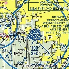
| Sectional chart |
|---|
|
 Download PDF
of official airport diagram from the FAA
| Airport distance calculator |
|---|
|
|
| Sunrise and sunset |
|---|
|
Times for 05-Jun-2026
| | Local
(UTC-4) | | Zulu
(UTC) |
|---|
| Morning civil twilight | | 05:25 | | 09:25 |
| Sunrise | | 05:59 | | 09:59 |
| Sunset | | 21:05 | | 01:05 |
| Evening civil twilight | | 21:39 | | 01:39 |
|
| Current date and time |
|---|
| Zulu (UTC) | 05-Jun-2026 15:34:43 |
|---|
| Local (UTC-4) | 05-Jun-2026 11:34:43 |
|---|
|
| METAR |
|---|
KDTW
2nm NE | 051453Z 20015G22KT 10SM FEW050 SCT250 27/14 A2999 RMK AO2 SLP152 T02670144 58012
|
KYIP
8nm W | 051453Z 23014G24KT 10SM FEW055 27/14 A2999 RMK AO2 SLP149 T02720144 58012
|
KONZ
11nm SE | 051515Z AUTO 19012KT 10SM BKN055 24/18 A2999 RMK AO2
|
KARB
17nm W | 734-668-7173
051453Z 22014G19KT 9SM FEW046 26/16 A2999 RMK AO2 SLP150 T02610156 58011
|
KTTF
17nm S | 051515Z AUTO 23014KT 10SM SCT050 26/16 A2999 RMK AO2
|
CYQG
18nm E | 051500Z AUTO 22016G25KT 9SM CLR 27/14 A2999 RMK SLP153 DENSITY ALT 2100FT
|
KDET
19nm NE | 051453Z 22019G26KT 10SM CLR 27/12 A2998 RMK AO2 PK WND 24026/1453 SLP146 T02670117 58015
|
|
| TAF |
|---|
KDTW
2nm NE | 051120Z 0512/0618 20005KT P6SM SCT070 SCT250 FM051500 23011KT P6SM SCT120 BKN250 FM051800 23013G20KT P6SM BKN060 OVC120 FM052300 21013KT 6SM -SHRA OVC045 TEMPO 0600/0604 3SM TSRA OVC030CB FM060400 23007KT 4SM BR OVC025 FM061600 26014KT P6SM SCT030 BKN100 PROB30 0616/0618 4SM -RA BKN030
|
KYIP
8nm W | 051120Z 0512/0612 20005KT P6SM SCT070 SCT250 FM051500 23011KT P6SM SCT120 BKN250 FM051800 23013G20KT P6SM BKN060 OVC120 FM052300 21013KT 6SM -SHRA OVC045 TEMPO 0600/0604 3SM TSRA OVC030CB FM060400 23007KT 4SM BR OVC025
|
CYQG
18nm E | 051140Z 0512/0612 22005KT P6SM SCT240 BECMG 0512/0514 22012KT FM051500 22012G22KT P6SM SCT070 BKN200 FM052100 24012G22KT P6SM BKN070 FM060100 24012G22KT P6SM -SHRA OVC040 PROB30 0601/0606 VRB20G30KT 2SM TSRA BR BKN020 OVC040CB FM060600 24012G22KT P6SM -SHRA SCT020 OVC030 RMK FCST BASED ON AUTO OBS. NXT FCST BY 051800Z
|
KDET
19nm NE | 051120Z 0512/0612 20005KT P6SM SCT070 SCT250 FM051500 23011KT P6SM SCT120 BKN250 FM051800 23013G20KT P6SM BKN060 OVC120 FM052300 21013KT 6SM -SHRA OVC045 TEMPO 0600/0604 3SM TSRA OVC030CB FM060400 23007KT 4SM BR OVC025
|
|
| NOTAMs |
|---|
NOTAMs are issued by the DoD/FAA and will open in a separate window not controlled by AirNav.
|
|


