FAA INFORMATION EFFECTIVE 09 JULY 2026
Location
| FAA Identifier: | MHR |
| Lat/Long: | 38-33-19.1190N 121-17-49.9610W
38-33.318650N 121-17.832683W
38.5553108,-121.2972114
(estimated) |
| Elevation: | 98.3 ft. / 30.0 m (surveyed) |
| Variation: | 13E (2020) |
| From city: | 10 miles E of SACRAMENTO, CA |
| Time zone: | UTC -7 (UTC -8 during Standard Time) |
| Zip code: | 95655 |
Airport Operations
| Airport use: | Open to the public |
| Activation date: | 07/1942 |
| Control tower: | yes |
| ARTCC: | OAKLAND CENTER |
| FSS: | RANCHO MURIETA FLIGHT SERVICE STATION |
| NOTAMs facility: | MHR (NOTAM-D service available) |
| Attendance: | 0500-2200 |
| Pattern altitude: | TPA FOR PISTON ACFT 1000 FT AGL; TURBINE ACFT 1800 FT AGL. |
| Wind indicator: | lighted |
| Segmented circle: | no |
| Lights: | WHEN ATCT CLSD ACTVT HIRL RWY 04R/22L; VASI RWY 04R & 22L; MALSR RWY 22L - CTAF. |
| Beacon: | white-green (lighted land airport)
Operates sunset to sunrise. |
Airport Communications
| CTAF: | 120.65 |
| UNICOM: | 122.95 |
| ATIS: | 118.325 |
| WX AWOS-3PT: | 118.325 (916-366-3371) |
| MATHER GROUND: | 121.85 307.9 [0500-2100] |
| MATHER TOWER: | 120.65 282.25 [0500-2100] |
| NORCAL APPROACH: | 127.4 |
| NORCAL DEPARTURE: | 127.4 |
| CLEARANCE DELIVERY: | 121.85 307.9 |
| WX AWOS-3 at MCC (8 nm NW): | 125.975 (916-641-1272) |
| WX ASOS at SAC (10 nm W): | PHONE 916-421-0923 |
| WX ASOS at SMF (16 nm NW): | PHONE 916-649-3996 |
| WX AWOS-3P at O61 (16 nm NE): | 120.0 (530-677-5392) |
- ATCT OPER BY SERCO.
- COMMUNICATIONS PRVDD BY RANCHO MURIETA RADIO ON FREQ 122.4 (SACRAMENTO RCO).
Nearby radio navigation aids
| VOR radial/distance | | VOR name | | Freq | | Var |
|---|
| MCCr126/8.4 | | MC CLELLAN VOR/DME | | 109.20 | | 17E |
| SACr044/13.7 | | SACRAMENTO VORTAC | | 115.20 | | 17E |
| HNWr231/27.6 | | HANGTOWN VOR/DME | | 115.50 | | 17E |
| LINr317/32.0 | | LINDEN VOR/DME | | 114.80 | | 17E |
| MYVr142/35.1 | | MARYSVILLE VOR/DME | | 110.80 | | 16E |
Airport Services
| Fuel available: | 100LL JET-A |
| Parking: | hangars and tiedowns |
| Airframe service: | MAJOR |
| Powerplant service: | MAJOR |
| Bulk oxygen: | LOW |
Runway Information
Runway 4R/22L
| Dimensions: | 11301 x 150 ft. / 3445 x 46 m |
| Surface: | asphalt/concrete, in good condition |
| Weight bearing capacity: | | Single wheel: | 160.0, SWL 65/PSI 640. | | Double wheel: | 280.0 | | Double tandem: | 500.0 |
|
| Runway edge lights: | high intensity |
| RUNWAY 4R | | RUNWAY 22L |
| Latitude: | 38-32.682890N | | 38-33.784902N |
| Longitude: | 121-18.810950W | | 121-16.899917W |
| Elevation: | 77.3 ft. | | 98.3 ft. |
| Traffic pattern: | right | | left |
| Runway heading: | 041 magnetic, 054 true | | 221 magnetic, 234 true |
| Markings: | precision, in good condition | | precision, in good condition |
| Visual slope indicator: | 4-box VASI on left (3.00 degrees glide path) | | 4-box VASI on left (3.00 degrees glide path) |
| RVR equipment: | touchdown, midfield, rollout | | touchdown, midfield, rollout |
| Approach lights: | | | MALSR: 1,400 foot medium intensity approach lighting system with runway alignment indicator lights |
| Touchdown point: | yes, no lights | | yes, no lights |
| Instrument approach: | | | ILS/DME |
Runway 4L/22R
| Dimensions: | 6081 x 150 ft. / 1853 x 46 m |
| Surface: | asphalt, in good condition |
| Weight bearing capacity: | | Single wheel: | 90.0 | | Double wheel: | 105.0 | | Double tandem: | 190.0 |
|
| Runway edge lights: | RWY 04L/22R MIRL DECOMISSIONED. |
| RUNWAY 4L | | RUNWAY 22R |
| Latitude: | 38-33.179518N | | 38-33.772503N |
| Longitude: | 121-18.304250W | | 121-17.276010W |
| Elevation: | 80.9 ft. | | 94.1 ft. |
| Traffic pattern: | left | | right |
| Runway heading: | 041 magnetic, 054 true | | 221 magnetic, 234 true |
| Markings: | nonprecision, in good condition | | nonprecision, in good condition |
| Runway end identifier lights: | no | | no |
| Touchdown point: | yes, no lights | | yes, no lights |
Helipad H2
| Dimensions: | 100 x 100 ft. / 30 x 30 m |
| Surface: | asphalt, in fair condition |
| Latitude: | 38-33.372667N | | |
| Longitude: | 121-17.130833W | | |
| Elevation: | 92.0 ft. | | |
| Traffic pattern: | left | | left |
Helipad H1
| Dimensions: | 30 x 30 ft. / 9 x 9 m |
| Surface: | asphalt, in fair condition |
| Latitude: | 38-33.766333N | | |
| Longitude: | 121-17.483500W | | |
| Elevation: | 95.0 ft. | | |
| Traffic pattern: | left | | left |
Airport Ownership and Management from official FAA records
| Ownership: | Publicly-owned |
| Owner: | COUNTY OF SACRAMENTO
6900 AIRPORT BLVD.
SACRAMENTO, CA 95837
Phone 916-875-7077 |
| Manager: | RON OGLE
10425 NORDEN AVE
MATHER, CA 95655
Phone 916-875-7077 |
Additional Remarks
| - | FOR CD WHEN ATCT IS CLSD CTC NORCAL APCH AT 916-361-6874. |
| - | TWY D1 CLSD TO ACFT WITH WINGSPAN MORE THAN 69 FT. |
| - | NO FLD COND NOTAMS AVBL 1600-0600. |
| - | RY 22L CALM WIND RY. |
| - | BE ALERT FOR LARGE TRANSPORT ACFT TKOFS & LNDGS AND HIGH PERFORMANCE MILITARY T-38 JETS. |
| - | AVOID NOISE SENSITIVE RESIDENTIAL AREAS NORTH/EAST OF RY 22L ILS FINAL APCH COURSE. TURBOJET NIGHTTIME NOISE ABATEMENT ARRIVAL AND DEPARTURE PROCEDURES IN EFFECT 2200-0700 DAILY. |
| - | PILOT INFORMATION ON NOISE ABATEMENT (916) 874-0359. |
| - | BIRDS INVOF OF ARPT. |
| - | ACFT ENTERING RY 22R TFC PAT FM THE NORTH SHOULD EXPECT TO FLY BASE LEG EXTENDED 2 MILES FM RY THLD. |
Instrument Procedures
NOTE: All procedures below are presented as PDF files. If you need a reader for these files, you should download the free Adobe Reader.NOT FOR NAVIGATION. Please procure official charts for flight.
FAA instrument procedures published for use from 09 July 2026 at 0901Z to 06 August 2026 at 0900Z.
STARs - Standard Terminal Arrivals |
|---|
| AMRVR TWO (RNAV) **NEW** | |
download (171KB) |
IAPs - Instrument Approach Procedures |
|---|
| ILS Y OR LOC Y RWY 22L | |
download (290KB) |
| ILS Z OR LOC Z RWY 22L | |
download (352KB) |
| ILS Z RWY 22L (SA CAT I - II) | |
download (317KB) |
| RNAV (GPS) RWY 04R | |
download (221KB) |
| RNAV (GPS) RWY 22L | |
download (250KB) |
| RNAV (GPS) RWY 22R | |
download (230KB) |
| NOTE: Special Alternate Minimums apply | |
download (138KB) |
| NOTE: Special Take-Off Minimums/Departure Procedures apply | |
download (128KB) |
Other nearby airports with instrument procedures:
KMCC - Mc Clellan Airfield (8 nm NW)
KSAC - Sacramento Executive Airport (10 nm W)
KSMF - Sacramento International Airport (16 nm NW)
1O3 - Lodi Airport (21 nm S)
KLHM - Lincoln Regional Airport/Karl Harder Field (21 nm N)
|
|

Road maps at:
MapQuest
Bing
Google
| Aerial photo |
|---|
WARNING: Photo may not be current or correct
 Photo courtesy of Mitch Bowers Imagewerx.us Aerial Photography
Photo taken 07-Nov-2008
from 10,500' looking south.
Photo courtesy of Mitch Bowers Imagewerx.us Aerial Photography
Photo taken 07-Nov-2008
from 10,500' looking south.
Do you have a better or more recent aerial photo of Sacramento Mather Airport that you would like to share? If so, please send us your photo.
|
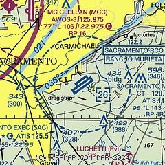
| Sectional chart |
|---|
|
CAUTION: Diagram may not be current
 Download PDF
of official airport diagram from the FAA
| Airport distance calculator |
|---|
|
|
| Sunrise and sunset |
|---|
|
Times for 28-Jul-2026
| | Local
(UTC-7) | | Zulu
(UTC) |
|---|
| Morning civil twilight | | 05:35 | | 12:35 |
| Sunrise | | 06:05 | | 13:05 |
| Sunset | | 20:19 | | 03:19 |
| Evening civil twilight | | 20:49 | | 03:49 |
|
| Current date and time |
|---|
| Zulu (UTC) | 29-Jul-2026 04:14:00 |
|---|
| Local (UTC-7) | 28-Jul-2026 21:14:00 |
|---|
|
| METAR |
|---|
| KMHR | 290355Z AUTO 22006KT 10SM CLR 26/13 A2978 RMK AO2 T02580126 $
|
KMCC
8nm NW | 290355Z AUTO 19006KT 10SM CLR 28/12 A2979 RMK AO2
|
KSAC
10nm W | 290353Z 20004KT 10SM CLR 26/13 A2979 RMK AO2 SLP087 T02560128
|
KSMF
17nm NW | 290353Z 17008KT 10SM CLR 27/14 A2978 RMK AO2 SLP082 T02720139
|
|
| TAF |
|---|
| KMHR | 281720Z 2818/2918 VRB05KT P6SM SKC FM282200 19010KT P6SM SKC FM290400 19008KT P6SM SKC FM291200 VRB05KT P6SM SKC
|
KMCC
8nm NW | 281720Z 2818/2918 VRB05KT P6SM SKC FM282200 20010KT P6SM SKC FM290400 21008KT P6SM SKC FM291200 VRB05KT P6SM SKC
|
KSAC
10nm W | 281720Z 2818/2918 VRB04KT P6SM SKC FM282200 19010KT P6SM SKC FM290400 19008KT P6SM SKC FM291200 VRB05KT P6SM SKC
|
KSMF
17nm NW | 281720Z 2818/2918 VRB04KT P6SM SKC FM282200 17010KT P6SM SKC FM290400 17008KT P6SM SKC FM291200 VRB05KT P6SM SKC
|
|
| NOTAMs |
|---|
NOTAMs are issued by the DoD/FAA and will open in a separate window not controlled by AirNav.
|
|


