FAA INFORMATION EFFECTIVE 25 DECEMBER 2025
Location
| FAA Identifier: | ORF |
| Lat/Long: | 36-53-40.5750N 076-12-04.4250W
36-53.676250N 076-12.073750W
36.8946042,-76.2012292
(estimated) |
| Elevation: | 26.4 ft. / 8.0 m (surveyed) |
| Variation: | 09W (1985) |
| From city: | 3 miles NE of NORFOLK, VA |
| Time zone: | UTC -5 (UTC -4 during Daylight Saving Time) |
| Zip code: | 23518 |
Airport Operations
| Airport use: | Open to the public |
| Activation date: | 03/1938 |
| Control tower: | yes |
| ARTCC: | WASHINGTON CENTER |
| FSS: | LEESBURG FLIGHT SERVICE STATION |
| NOTAMs facility: | ORF (NOTAM-D service available) |
| Attendance: | CONTINUOUS |
| Wind indicator: | lighted |
| Segmented circle: | no |
| Lights: | SS-SR |
| Beacon: | white-green (lighted land airport)
Operates sunset to sunrise. |
| Landing fee: | yes |
| Fire and rescue: | ARFF index C |
| International operations: | customs landing rights airport |
Airport Communications
| ATIS: | 127.15 |
| WX ASOS: | PHONE 276-200-0952 |
| NORFOLK GROUND: | 121.9 |
| NORFOLK TOWER: | 120.8 257.8 |
| NORFOLK APPROACH: | 118.9 ;010-080, 180-310 335.625 353.7 ;010-080, 180-310 |
| NORFOLK DEPARTURE: | 125.2 363.125 379.1 |
| CLEARANCE DELIVERY: | 118.5 |
| PRE-TAXI CLEARANCE: | 118.5 |
| CLASS C: | 118.9 ;010-080, 180-310 125.7 ;311-009 353.7 ;010-080, 180-310 379.1 ;311-009 |
| DRONE STAR: | 118.9 353.7 |
| EMERG: | 121.5 243.0 |
| HOLND DP: | 125.2 363.125 |
| IC: | 118.9 ;010-080, 180-310 353.7 ;010-080, 180-310 |
| NUTIY DP: | 125.2 363.125 |
| SWOPE DP: | 125.2 363.125 |
| TERKS STAR: | 118.9 353.7 |
| WX ASOS at NTU (9 nm SE): | PHONE DSN 433-3619 or 757-433-3619 |
| WX AWOS-3PT at PVG (14 nm SW): | 118.375 (757-465-2175) |
| WX AWOS-3 at CPK (15 nm SW): | 123.675 (757-204-4290) |
| WX ASOS at PHF (20 nm NW): | PHONE 757-874-3682 |
- SAID IN USE. OPERATE TRANSPONDERS WITH ALTITUDE REPORTING MODE AND ADS-B (IF EQUIPPED) ENABLED ON ALL AIRPORT SURFACES.
Nearby radio navigation aids
| VOR radial/distance | | VOR name | | Freq | | Var |
|---|
| ORF at field | | NORFOLK VORTAC | | 116.90 | | 07W |
| CCVr210/28.9 | | CAPE CHARLES VORTAC | | 112.20 | | 10W |
| ECGr005/38.2 | | ELIZABETH CITY VOR/DME | | 115.75 | | 07W |
| NDB name | | Hdg/Dist | | Freq | | Var | | ID |
|---|
| WOODVILLE | | 017/38.2 | | 254 | | 10W | | LLW | .-.. .-.. .-- |
| WAKEFIELD | | 109/38.7 | | 274 | | 11W | | AKQ | .- -.- --.- |
Airport Services
| Fuel available: | 100LL JET-A |
| Parking: | hangars and tiedowns |
| Airframe service: | MINOR |
| Powerplant service: | MINOR |
| Bottled oxygen: | LOW |
| Bulk oxygen: | HIGH/LOW |
Runway Information
Runway 5/23
| Dimensions: | 9001 x 150 ft. / 2744 x 46 m |
| Surface: | asphalt/concrete/grooved, in fair condition
CONC PTNS: LONGL CRACKS & SPALLING. |
| Weight bearing capacity: | | Single wheel: | 120.0 | | Double wheel: | 250.0 | | Double tandem: | 550.0 | | Dual double tandem: | 1120.0 |
|
| Runway edge lights: | high intensity |
| RUNWAY 5 | | RUNWAY 23 |
| Latitude: | 36-53.151735N | | 36-54.323957N |
| Longitude: | 076-12.497712W | | 076-11.366033W |
| Elevation: | 17.7 ft. | | 15.0 ft. |
| Traffic pattern: | right | | left |
| Runway heading: | 047 magnetic, 038 true | | 227 magnetic, 218 true |
| Displaced threshold: | 1001 ft. | | no |
| Declared distances: | TORA:9001 TODA:9001 ASDA:8809 LDA:7809 | | TORA:9001 TODA:9001 ASDA:8995 LDA:8995 |
| Markings: | precision, in good condition | | precision, in good condition |
| Visual slope indicator: | 4-light PAPI on left (3.00 degrees glide path) | | 4-light PAPI on left (3.00 degrees glide path) |
| RVR equipment: | touchdown | | rollout |
| Approach lights: | MALSR: 1,400 foot medium intensity approach lighting system with runway alignment indicator lights | | MALSR: 1,400 foot medium intensity approach lighting system with runway alignment indicator lights |
| Runway end identifier lights: | no | | no |
| Centerline lights: | yes | | yes |
| Touchdown point: | yes, no lights | | yes, no lights |
| Instrument approach: | ILS/DME | | ILS/DME |
| Obstructions: | 41 ft. trees, 2100 ft. from runway, 380 ft. left of centerline, 46:1 slope to clear
APCH RATIO 50:1 TO DSPLCD THR. | | 49 ft. pole, lighted, 1500 ft. from runway, 150 ft. right of centerline, 26:1 slope to clear
RWY 23 +1' FNC 80' FM RY END 400' R 10' FCN 0-200 270' L |
Runway 14/32
| Dimensions: | 4876 x 150 ft. / 1486 x 46 m |
| Surface: | asphalt/grooved, in good condition |
| Weight bearing capacity: | | Single wheel: | 120.0 | | Double wheel: | 250.0 | | Double tandem: | 550.0 | | Dual double tandem: | 1120.0 |
|
| Runway edge lights: | medium intensity |
| Operational restrictions: | RWY 14/32 CLSD INDEFLY. |
| RUNWAY 14 | | RUNWAY 32 |
| Latitude: | 36-53.809743N | | 36-53.315202N |
| Longitude: | 076-12.729767W | | 076-11.941347W |
| Elevation: | 17.7 ft. | | 21.7 ft. |
| Traffic pattern: | right | | left |
| Runway heading: | 137 magnetic, 128 true | | 317 magnetic, 308 true |
| Displaced threshold: | 575 ft. | | no |
| Declared distances: | TORA:4876 TODA:4876 ASDA:4876 LDA:4301 | | TORA:4876 TODA:4876 ASDA:3901 LDA:3901 |
| Markings: | nonprecision, in good condition | | nonprecision, in good condition |
| Visual slope indicator: | 2-light PAPI on left (3.00 degrees glide path) | | 2-light PAPI on left (3.00 degrees glide path) |
| Runway end identifier lights: | yes | | yes |
| Touchdown point: | yes, no lights | | yes, no lights |
| Obstructions: | 61 ft. tree, 1226 ft. from runway, 74 ft. both sides of centerline, 16:1 slope to clear
APCH RATIO 26:1 TO DSPLCD THR. | | 103 ft. tree, 2590 ft. from runway, 430 ft. left of centerline, 23:1 slope to clear |
Airport Ownership and Management from official FAA records
| Ownership: | Publicly-owned |
| Owner: | NORFOLK AIRPORT AUTH
2200 NORVIEW AVE
NORFOLK, VA 23518-5807
Phone 757-857-3351 |
| Manager: | ANTHONY RONDEAU
2200 NORVIEW AVE
NORFOLK, VA 23518-5807
Phone 757-857-3344
POLICE DISPATCH. |
Additional Remarks
| A39-05/23 | PCR VALUE: 630/F/A/X/T |
| A39-14/32 | PCR VALUE: 602/F/A/X/T |
| - | NOISE ABATEMENT PROCEDURES IN EFFECT. |
| - | FLOCKS OF BIRDS ON & INVOF ARPT. |
| - | INTMT AIRFIELD MOWING OPS MAR - NOV. |
Instrument Procedures
NOTE: All procedures below are presented as PDF files. If you need a reader for these files, you should download the free Adobe Reader.NOT FOR NAVIGATION. Please procure official charts for flight.
FAA instrument procedures published for use from 25 December 2025 at 0901z to 22 January 2026 at 0900z.
STARs - Standard Terminal Arrivals |
|---|
| DRONE TWO | |
2 pages:
[1] [2] (265KB) |
| TERKS TWO | |
download (168KB) |
IAPs - Instrument Approach Procedures |
|---|
| ILS OR LOC RWY 05 **CHANGED** | |
download (261KB) |
| ILS OR LOC RWY 23 **CHANGED** | |
download (244KB) |
| RNAV (RNP) Y RWY 05 **CHANGED** | |
download (199KB) |
| RNAV (RNP) Y RWY 23 **CHANGED** | |
download (201KB) |
| RNAV (GPS) RWY 14 **CHANGED** | |
download (192KB) |
| RNAV (GPS) RWY 32 **CHANGED** | |
download (195KB) |
| RNAV (GPS) Z RWY 05 **CHANGED** | |
download (254KB) |
| RNAV (GPS) Z RWY 23 **CHANGED** | |
download (203KB) |
| VOR/DME RWY 32 **CHANGED** | |
download (182KB) |
| VOR RWY 14 **CHANGED** | |
download (187KB) |
| RIVER VISUAL RWY 05 | |
download (208KB) |
| NOTE: Special Alternate Minimums apply | |
download (152KB) |
Departure Procedures |
|---|
| HOLND ONE (RNAV) **CHANGED** | |
download (226KB) |
| NUTIY ONE (RNAV) **CHANGED** | |
2 pages:
[1] [2] (404KB) |
| SWOPE ONE (RNAV) **CHANGED** | |
2 pages:
[1] [2] (312KB) |
| NOTE: Special Take-Off Minimums/Departure Procedures apply | |
download |
Other nearby airports with instrument procedures:
KNGU - Norfolk Naval Station (Chambers Field) (5 nm NW)
KNHU - Norfolk Naval Station Airport (6 nm NW)
KNTU - Oceana Naval Air Station (Apollo Soucek Field) (9 nm SE)
KLFI - Langley Air Force Base (14 nm NW)
KPVG - Hampton Roads Executive Airport (14 nm SW)
KCPK - Chesapeake Regional Airport (15 nm SW)
KPHF - Newport News/Williamsburg International Airport (20 nm NW)
|
|

Road maps at:
MapQuest
Bing
Google
| Aerial photo |
|---|
WARNING: Photo may not be current or correct
 Photo by David Newcomer
Taken in June 2009
from 6000' altitude.
Photo by David Newcomer
Taken in June 2009
from 6000' altitude.
Do you have a better or more recent aerial photo of Norfolk International Airport that you would like to share? If so, please send us your photo.
|
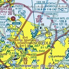
| Sectional chart |
|---|
|
CAUTION: Diagram may not be current
 Download PDF
of official airport diagram from the FAA
| Airport distance calculator |
|---|
|
|
| Sunrise and sunset |
|---|
|
Times for 21-Jan-2026
| | Local
(UTC-5) | | Zulu
(UTC) |
|---|
| Morning civil twilight | | 06:48 | | 11:48 |
| Sunrise | | 07:16 | | 12:16 |
| Sunset | | 17:17 | | 22:17 |
| Evening civil twilight | | 17:45 | | 22:45 |
|
| Current date and time |
|---|
| Zulu (UTC) | 21-Jan-2026 11:11:07 |
|---|
| Local (UTC-5) | 21-Jan-2026 06:11:07 |
|---|
|
| METAR |
|---|
| KORF | 211051Z 00000KT 10SM CLR M05/M06 A3054 RMK AO2 SLP340 T10501061 $
|
KNGU
3nm NW | 211059Z 00000KT 10SM CLR M05/M06 A3055 RMK AO2 SLP343 I1001 T10501056 $
|
KNTU
10nm SE | 211056Z 00000KT 10SM CLR M06/M07 A3054 RMK AO2 SLP343 T10561072
|
KNFE
13nm S | 211058Z AUTO 00000KT 10SM CLR M07/M08 A3055 RMK AO2 SLP346 T10721083
|
KLFI
13nm NW | 211055Z AUTO 00000KT 10SM CLR M06/M09 A3054 RMK AO2 SLP349 T10621088 $
|
KPVG
14nm SW | 211056Z AUTO 00000KT 10SM CLR M09/M10 A3055 RMK AO2 SLP348 T10941100 FZRANO $
|
KCPK
15nm S | 211055Z AUTO 00000KT 10SM CLR M09/M11 A3055 RMK AO2 T10921108
|
|
| TAF |
|---|
| KORF | 210530Z 2106/2206 VRB02KT P6SM SKC FM211400 19009KT P6SM SCT250 FM220000 20005KT P6SM BKN150 WS020/23040KT
|
KNGU
3nm NW | 2107/2207 VRB06KT 9999 FEW030 QNH3041INS BECMG 2115/2117 20008KT 9999 FEW040 SCT120 SCT250 QNH3037INS FM220500 23010G15KT 9999 SCT080 BKN120 BKN250 QNH3021INS TX09/2118Z TNM06/2109Z FN00286
|
KNTU
10nm SE | 2023/2123 VRB04KT 9999 SKC QNH3035INS FM211400 21010KT 9999 SCT040 BKN250 QNH3030INS TX07/2118Z TNM07/2110Z FN20051
|
KLFI
13nm NW | 211000Z 2110/2216 VRB06KT 9999 SKC QNH3051INS BECMG 2115/2116 19009KT 9999 FEW250 QNH3030INS BECMG 2121/2122 19012G18KT 9999 SCT080 BKN150 QNH3020INS BECMG 2205/2206 20010G15KT 9999 FEW040 SCT080 BKN150 QNH3018INS TX10/2119Z TNM06/2110Z
|
|
| NOTAMs |
|---|
NOTAMs are issued by the DoD/FAA and will open in a separate window not controlled by AirNav.
|
|


