FAA INFORMATION EFFECTIVE 11 JUNE 2026
Location
| FAA Identifier: | 08C |
| Lat/Long: | 42-56-12.2015N 085-48-20.7090W
42-56.203358N 085-48.345150W
42.9367226,-85.8057525
(estimated) |
| Elevation: | 603 ft. / 184 m (estimated) |
| From city: | 3 miles NW of JENISON, MI |
| Time zone: | UTC -4 (UTC -5 during Standard Time) |
| Zip code: | 49428 |
Airport Operations
| Airport use: | Open to the public |
| Control tower: | no |
| ARTCC: | CHICAGO CENTER |
| FSS: | LANSING FLIGHT SERVICE STATION |
| NOTAMs facility: | LAN (NOTAM-D service available) |
| Attendance: | MON-FRI 0800-1700, ALL SAT-SUN IREG |
| Wind indicator: | lighted |
| Segmented circle: | yes |
| Lights: | ACTVT MIRL RWY 14/32 - CTAF. |
| Beacon: | white-green (lighted land airport)
OPRS DUSK-2400. |
Airport Communications
| CTAF: | 122.9 |
| WX AWOS-3PT at 8D4 (13 nm NE): | 126.650 (616-887-6314) |
| WX ASOS at GRR (13 nm E): | PHONE 616-986-5029 |
| WX ASOS at BIV (18 nm SW): | 119.025 (616-394-0190) |
Nearby radio navigation aids
| VOR radial/distance | | VOR name | | Freq | | Var |
|---|
| VIOr308/16.3 | | VICTORY VOR/DME | | 115.95 | | 04W |
| PMMr025/31.2 | | PULLMAN VOR/DME | | 112.10 | | 00E |
Airport Services
| Fuel available: | 100LL
100LL:FUEL AVBL H24 SELF SVC. |
| Parking: | hangars and tiedowns |
| Airframe service: | MAJOR |
| Powerplant service: | MAJOR |
| Bottled oxygen: | NONE |
| Bulk oxygen: | NONE |
Runway Information
Runway 14/32
| Dimensions: | 3920 x 49 ft. / 1195 x 15 m |
| Surface: | asphalt, in fair condition |
| Runway edge lights: | medium intensity |
| Runway edge markings: | RWY NRS FADED. |
| RUNWAY 14 | | RUNWAY 32 |
| Latitude: | 42-56.447258N | | 42-55.959457N |
| Longitude: | 085-48.632813W | | 085-48.057485W |
| Elevation: | 603.0 ft. | | 603.0 ft. |
| Traffic pattern: | left | | left |
| Runway heading: | 139 true | | 319 true |
| Displaced threshold: | no | | 1196 ft. |
| Markings: | basic, in poor condition | | basic, in poor condition |
| Obstructions: | 64 ft. trees, 660 ft. from runway, 100 ft. right of centerline, 7:1 slope to clear | | 80 ft. trees, 450 ft. from runway, 70 ft. right of centerline, 3:1 slope to clear
+8 FT ROAD & 11-52 FT TREES, 55-155 FT DIST, 140 FT L/R. |
Airport Ownership and Management from official FAA records
| Ownership: | Privately-owned |
| Owner: | RIVERTOWN AIRPORT LLC
805 TAYLOR ST
JENISON, MI 49428-9560
Phone 616-457-5040 |
| Manager: | NATHAN D BOYNTON
805 TAYLOR ST
JENISON, MI 49428-9560
Phone 616-457-5040
CELL 616-291-2778. |
Additional Remarks
| - | DEER, BIRDS, & GROUNDHOGS ON & INVOF ARPT. |
| - | ADMIN BLDG ACES: 5-3-2-1. |
| - | FOR CD CTC GREAT LAKES APCH AT 269-459-3344, WHEN APCH CLSD CTC CHICAGO ARTCC AT 630-906-8921. |
Instrument Procedures
There are no published instrument procedures at 08C.
Some nearby airports with instrument procedures:
Z98 - Ottawa Executive Airport (9 nm SW)
8D4 - Paul C Miller/Sparta Airport (13 nm NE)
KGRR - Gerald R Ford International Airport (13 nm E)
KBIV - West Michigan Regional Airport (18 nm SW)
3GM - Grand Haven Memorial Airpark (18 nm W)
|
|

Road maps at:
MapQuest
Bing
Google
| Aerial photo |
|---|
WARNING: Photo may not be current or correct
 Photo by Timothy Hoffman
Photo taken 08-Aug-2012
looking southwest.
Photo by Timothy Hoffman
Photo taken 08-Aug-2012
looking southwest.
Do you have a better or more recent aerial photo of Riverview Airport that you would like to share? If so, please send us your photo.
|
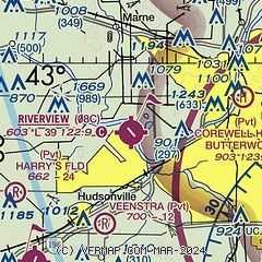
| Sectional chart |
|---|
|
| Airport distance calculator |
|---|
|
|
| Sunrise and sunset |
|---|
|
Times for 14-Jun-2026
| | Local
(UTC-4) | | Zulu
(UTC) |
|---|
| Morning civil twilight | | 05:29 | | 09:29 |
| Sunrise | | 06:05 | | 10:05 |
| Sunset | | 21:22 | | 01:22 |
| Evening civil twilight | | 21:57 | | 01:57 |
|
| Current date and time |
|---|
| Zulu (UTC) | 14-Jun-2026 22:05:07 |
|---|
| Local (UTC-4) | 14-Jun-2026 18:05:07 |
|---|
|
| METAR |
|---|
KGRR
13nm E | 142053Z 29013G26KT 10SM BKN040 19/11 A2980 RMK AO2 PK WND 27029/1957 SLP088 T01940106 53008 $
|
KBIV
17nm SW | 142153Z AUTO 31017G28KT 10SM OVC055 17/11 A2989 RMK AO2 PK WND 32029/2121 SLP120 T01720106 PNO $
|
KMKG
23nm NW | 142055Z 32018G26KT 10SM OVC055 18/10 A2985 RMK AO2 PK WND 30029/1958 SLP107 T01780100 53016 $
|
|
| TAF |
|---|
KGRR
13nm E | 141740Z 1418/1518 28011G19KT P6SM BKN040 FM150000 32008KT P6SM SCT040 FM150300 VRB04KT P6SM SCT250
|
|
| NOTAMs |
|---|
NOTAMs are issued by the DoD/FAA and will open in a separate window not controlled by AirNav.
|
|

