FAA INFORMATION EFFECTIVE 12 JUNE 2025
Location
| FAA Identifier: | 0L7 |
| Lat/Long: | 35-46-05.7517N 115-19-46.6391W
35-46.095862N 115-19.777318W
35.7682644,-115.3296220
(estimated) |
| Elevation: | 2835 ft. / 864.1 m (surveyed) |
| Variation: | 14E (1985) |
| From city: | 1 mile S of JEAN, NV |
| Time zone: | UTC -7 (UTC -8 during Standard Time) |
| Zip code: | 89019 |
Airport Operations
| Airport use: | Open to the public |
| Activation date: | 03/1943 |
| Control tower: | no |
| ARTCC: | LOS ANGELES CENTER |
| FSS: | RENO FLIGHT SERVICE STATION |
| NOTAMs facility: | RNO (NOTAM-D service available) |
| Attendance: | UNATNDD |
| Pattern altitude: | 3635 ft. MSL |
| Wind indicator: | yes |
| Segmented circle: | yes |
| Lights: | ACTVT MIRL RWY 02L/20R - CTAF. |
| Beacon: | white-green (lighted land airport)
Operates sunset to sunrise. |
Airport Communications
| CTAF: | 122.9 |
| WX AWOS-3PT at HND (16 nm NE): | 120.775 (702-614-4537) |
Nearby radio navigation aids
| VOR radial/distance | | VOR name | | Freq | | Var |
|---|
| LASr189/20.4 | | LAS VEGAS VORTAC | | 116.90 | | 15E |
| BLDr224/26.5 | | BOULDER CITY VORTAC | | 116.70 | | 15E |
| GFSr334/39.0 | | GOFFS VORTAC | | 114.40 | | 15E |
Airport Services
| Fuel available: | 100LL JET-A
100LL:24 HR SELF SVC FUEL. |
| Parking: | tiedowns |
Runway Information
Runway 2L/20R
| Dimensions: | 4600 x 75 ft. / 1402 x 23 m |
| Surface: | asphalt, in good condition |
| Weight bearing capacity: | |
| Runway edge lights: | medium intensity |
| RUNWAY 2L | | RUNWAY 20R |
| Latitude: | 35-45.801667N | | 35-46.444667N |
| Longitude: | 115-20.035000W | | 115-19.542000W |
| Elevation: | 2816.7 ft. | | 2834.6 ft. |
| Traffic pattern: | left | | right |
| Runway heading: | 018 magnetic, 032 true | | 198 magnetic, 212 true |
| Markings: | basic, in good condition | | basic, in good condition |
| Touchdown point: | yes, no lights | | yes, no lights |
| Obstructions: | 30 ft. pole, 1230 ft. from runway, 180 ft. left of centerline, 34:1 slope to clear | | 15 ft. road, 830 ft. from runway, 42:1 slope to clear |
Runway 2R/20L
| Dimensions: | 3700 x 60 ft. / 1128 x 18 m |
| Surface: | asphalt, in good condition |
| Weight bearing capacity: | |
| RUNWAY 2R | | RUNWAY 20L |
| Latitude: | 35-45.803333N | | 35-46.320500N |
| Longitude: | 115-19.961667W | | 115-19.565167W |
| Elevation: | 2814.5 ft. | | 2827.9 ft. |
| Traffic pattern: | right | | left |
| Runway heading: | 018 magnetic, 032 true | | 198 magnetic, 212 true |
| Markings: | basic, in good condition | | basic, in good condition |
| Touchdown point: | yes, no lights | | yes, no lights |
| Obstructions: | none | | 85 ft. pole, 1940 ft. from runway, 510 ft. left of centerline, 20:1 slope to clear |
Airport Ownership and Management from official FAA records
| Ownership: | Publicly-owned |
| Owner: | CLARK COUNTY
PO BOX 11005 AIRPORT STATION
LAS VEGAS, NV 89111
Phone 702-261-4800 |
| Manager: | BRUCE DAUGHERTY
3500 EXECUTIVE TERMINAL DR
HENDERSON, NV 89052
Phone 702-261-4802
JUSTIN DI AMBROSIO - 702-261-4851 |
Additional Remarks
| - | PWR ACFT PRKG W OF FLD; GLDR PRKG E OF FLD. |
| - | FOR CD CTC LAS VEGAS APCH AT 725-200-4432. |
| - | PWR ACFT ENTRY FM W; USE TFC PAT W OF RWY. |
| - | SKYDIVING DROP ZONE 4 MI S; AEROBATIC ACT 2 MI W; ULTRALIGHT ACT ON ARPT. |
| - | GLDR ACT 12000 FT MSL & BLW INVOF ARPT. |
Instrument Procedures
There are no published instrument procedures at 0L7.
Some nearby airports with instrument procedures:
KHND - Henderson Executive Airport (16 nm NE)
KLAS - Harry Reid International Airport (21 nm NE)
KBVU - Boulder City Municipal Airport (25 nm NE)
KVGT - North Las Vegas Airport (27 nm N)
KLSV - Nellis Air Force Base (32 nm NE)
|
|

Road maps at:
MapQuest
Bing
Google
| Aerial photo |
|---|
WARNING: Photo may not be current or correct
 Photo by Jassen Photography
Photo taken 18-Oct-2015
looking south.
Photo by Jassen Photography
Photo taken 18-Oct-2015
looking south.
Do you have a better or more recent aerial photo of Jean Airport that you would like to share? If so, please send us your photo.
|
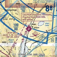
| Sectional chart |
|---|
|
| Airport distance calculator |
|---|
|
|
| Sunrise and sunset |
|---|
|
Times for 01-Jul-2025
| | Local
(UTC-7) | | Zulu
(UTC) |
|---|
| Morning civil twilight | | 05:00 | | 12:00 |
| Sunrise | | 05:30 | | 12:30 |
| Sunset | | 20:00 | | 03:00 |
| Evening civil twilight | | 20:30 | | 03:30 |
|
| Current date and time |
|---|
| Zulu (UTC) | 01-Jul-2025 20:04:34 |
|---|
| Local (UTC-7) | 01-Jul-2025 13:04:34 |
|---|
|
| METAR |
|---|
KHND
16nm NE | 011956Z 19022G34KT 160V230 10SM FEW110 37/06 A2988 RMK AO2 PK WND 21034/1956 SLP099 T03720056 $
|
KLAS
21nm NE | 011956Z 12010G23KT 10SM SCT120 BKN180 BKN250 38/04 A2986 RMK AO2 PK WND 15026/1946 SLP078 VIRGA NE-S T03780044
|
KBVU
25nm NE | 011955Z AUTO 19010KT 10SM CLR 37/01 A2984 RMK AO2
|
KVGT
27nm N | 011953Z 14014G20KT 10SM FEW090 39/10 A2985 RMK AO2 SLP090 T03890100
|
KLSV
31nm NE | 011955Z 17026G40KT 2SM -SHRA BLDU 39/00 A2980 RMK SLP059 T03860001 RVRNO $
|
|
| TAF |
|---|
KHND
16nm NE | 011735Z 0118/0218 16010KT P6SM SCT120 BKN180 BKN250 FM011900 17016G26KT P6SM -RA SCT150 FM012100 24016G26KT P6SM SCT150 PROB30 0121/0124 -TSRA SCT100CB FM020300 10014G22KT P6SM SCT150 SCT250 FM020500 VRB06KT P6SM SCT150 SCT250 FM021600 16009KT P6SM SCT150 SCT250
|
|
| NOTAMs |
|---|
NOTAMs are issued by the DoD/FAA and will open in a separate window not controlled by AirNav.
|
|


