FAA INFORMATION EFFECTIVE 14 MAY 2026
Location
| FAA Identifier: | 1B9 |
| Lat/Long: | 42-00-03.1650N 071-11-52.9480W
42-00.052750N 071-11.882467W
42.0008792,-71.1980411
(estimated) |
| Elevation: | 122.9 ft. / 37.5 m (surveyed) |
| Variation: | 16W (1995) |
| From city: | 2 miles SE of MANSFIELD, MA |
| Time zone: | UTC -4 (UTC -5 during Standard Time) |
| Zip code: | 02048 |
Airport Operations
| Airport use: | Open to the public |
| Activation date: | 05/1943 |
| Control tower: | no |
| ARTCC: | BOSTON CENTER |
| FSS: | BRIDGEPORT FLIGHT SERVICE STATION |
| NOTAMs facility: | BDR (NOTAM-D service available) |
| Attendance: | APR-NOV 0800-DUSK, DEC-MAR 0900-1700 |
| Wind indicator: | yes |
| Segmented circle: | no |
| Lights: | ACTVT PAPI RWY 32; MIRL RWY 14/32 - CTAF. |
| Beacon: | white-green (lighted land airport)
ROTG BCN OTS. Operates sunset to sunrise. |
Airport Communications
| CTAF/UNICOM: | 123.0 |
| WX AWOS-3PT: | 118.675 (774-372-2047) |
| BOSTON APPROACH: | 124.1 |
| BOSTON DEPARTURE: | 124.1 |
| WOONS STAR: | 120.6 |
| WX ASOS at TAN (11 nm SE): | 132.675 (508-824-5005) |
| WX ASOS at OWD (11 nm N): | 119.95 (781-762-4314) |
| WX AWOS-3PT at SFZ (14 nm W): | 120.775 (401-334-0324) |
| WX ASOS at PVD (20 nm SW): | 124.2 (401-734-2818) |
Nearby radio navigation aids
| VOR radial/distance | | VOR name | | Freq | | Var |
|---|
| PVDr046/19.6 | | PROVIDENCE VOR/DME | | 115.60 | | 14W |
| BOSr219/23.3 | | BOSTON VOR/DME | | 112.70 | | 16W |
| PUTr099/28.9 | | PUTNAM VOR/DME | | 117.40 | | 14W |
Airport Services
| Fuel available: | 100LL |
| Parking: | tiedowns |
| Airframe service: | MAJOR |
| Powerplant service: | MAJOR |
| Bottled oxygen: | NONE |
| Bulk oxygen: | NONE |
Runway Information
Runway 14/32
| Dimensions: | 3500 x 75 ft. / 1067 x 23 m |
| Surface: | asphalt, in good condition |
| Weight bearing capacity: | |
| Runway edge lights: | medium intensity |
| RUNWAY 14 | | RUNWAY 32 |
| Latitude: | 42-00.156833N | | 41-59.846542N |
| Longitude: | 071-12.118583W | | 071-11.467663W |
| Elevation: | 121.4 ft. | | 119.0 ft. |
| Traffic pattern: | left | | left |
| Runway heading: | 139 magnetic, 123 true | | 319 magnetic, 303 true |
| Displaced threshold: | 509 ft. | | 237 ft. |
| Markings: | basic, in good condition | | nonprecision, in good condition |
| Visual slope indicator: | | | 4-light PAPI on left (4.00 degrees glide path) |
| Touchdown point: | yes, no lights | | yes, no lights |
| Obstructions: | 50 ft. trees, 1200 ft. from runway, 20:1 slope to clear
APCH RATIO 34:1 TO DTHR. | | 50 ft. trees, 800 ft. from runway, 125 ft. left and right of centerline, 12:1 slope to clear
APCH RATIO 34:1 TO DTHR. |
Runway 4/22
| Dimensions: | 2059 x 100 ft. / 628 x 30 m |
| Surface: | turf, in good condition |
| RUNWAY 4 | | RUNWAY 22 |
| Latitude: | 41-59.989857N | | 42-00.289240N |
| Longitude: | 071-12.140922W | | 071-11.927852W |
| Elevation: | 116.8 ft. | | 122.9 ft. |
| Traffic pattern: | left | | left |
| Runway heading: | 044 magnetic, 028 true | | 224 magnetic, 208 true |
| Markings: | none | | none |
| Touchdown point: | yes, no lights | | yes, no lights |
| Obstructions: | 42 ft. trees, 830 ft. from runway, 20:1 slope to clear | | 100 ft. trees, 600 ft. from runway, 40 ft. of centerline, 6:1 slope to clear |
Airport Ownership and Management from official FAA records
| Ownership: | Publicly-owned |
| Owner: | TOWN OF MANSFIELD
TOWN HALL, 6 PARK ROW
MANSFIELD, MA 02048
Phone 508-261-7370 |
| Manager: | KEVIN BULLOCK
265 FRUIT ST
MANSFIELD, MA 02048
Phone 508-930-1121
OR 508-339-3001. |
Additional Remarks
| - | TURF STRIP CLSD WINTER MONTHS & AFT HVY RAINS. |
| - | ON DEP RWY 32 TURN L TO 290 DEGS. |
| - | ON DEP RWY 14 NO L TURNS TIL 824 FT MSL. |
| - | NO TGLS 2100-0800. |
| - | NO R TURNS ON DEP FM RWY 32 TIL 1000 FT MSL. |
| - | FOR CD CTC BOSTON APCH AT 603-594-5554. |
| - | WILDLIFE ON & INVOF ARPT. |
| - | RWY 14/32 LGTS OTS. |
Instrument Procedures
NOTE: All procedures below are presented as PDF files. If you need a reader for these files, you should download the free Adobe Reader.NOT FOR NAVIGATION. Please procure official charts for flight.
FAA instrument procedures published for use from 14 May 2026 at 0901Z to 11 June 2026 at 0900z.
STARs - Standard Terminal Arrivals |
|---|
| WOONS TWO | |
download (157KB) |
IAPs - Instrument Approach Procedures |
|---|
| RNAV (GPS) RWY 32 | |
download (267KB) |
| RNAV (GPS) Z RWY 14 | |
download (241KB) |
| COPTER RNAV (GPS) Y RWY 14 | |
download (215KB) |
| NOTE: Special Alternate Minimums apply | |
download (150KB) |
| NOTE: Special Take-Off Minimums/Departure Procedures apply | |
download (180KB) |
Other nearby airports with instrument procedures:
KTAN - Taunton Municipal Airport/King Field (11 nm SE)
KOWD - Norwood Memorial Airport (11 nm N)
KSFZ - North Central State Airport (14 nm W)
1B6 - Hopedale Industrial Park Airport (15 nm NW)
KPVD - Rhode Island TF Green International Airport (20 nm SW)
|
|

Road maps at:
MapQuest
Bing
Google
| Aerial photo |
|---|
WARNING: Photo may not be current or correct
 Photo by Barry Turner
Photo taken 01-Oct-2017
looking east.
Photo by Barry Turner
Photo taken 01-Oct-2017
looking east.
Do you have a better or more recent aerial photo of Mansfield Municipal Airport that you would like to share? If so, please send us your photo.
|
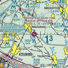
| Sectional chart |
|---|
|
| Airport distance calculator |
|---|
|
|
| Sunrise and sunset |
|---|
|
Times for 15-May-2026
| | Local
(UTC-4) | | Zulu
(UTC) |
|---|
| Morning civil twilight | | 04:53 | | 08:53 |
| Sunrise | | 05:25 | | 09:25 |
| Sunset | | 19:57 | | 23:57 |
| Evening civil twilight | | 20:29 | | 00:29 |
|
| Current date and time |
|---|
| Zulu (UTC) | 15-May-2026 12:10:06 |
|---|
| Local (UTC-4) | 15-May-2026 08:10:06 |
|---|
|
| METAR |
|---|
KTAN
11nm SE | 151152Z AUTO 00000KT 10SM OVC005 11/10 A2978 RMK AO2 SLP085 70011 T01060100 10106 20056 52018
|
KOWD
11nm N | 151204Z 34003KT 10SM SCT011 12/10 A2979 RMK AO2 T01170100
|
KSFZ
14nm W | 151156Z AUTO 01007KT 10SM FEW009 11/ A2979 RMK AO2 SLP088 70022 T0106 10106 20067 53016 $
|
KPVD
20nm SW | 151151Z 36010KT 10SM FEW006 FEW044 FEW065 SCT250 12/09 A2978 RMK AO2 SLP086 70004 T01220094 10122 20083 53016 $
|
KPYM
21nm E | 151152Z AUTO 33006KT 10SM OVC010 11/10 A2977 RMK AO2 CIG 007V015 SLP084 70016 T01060100 10111 20072 53017
|
|
| NOTAMs |
|---|
NOTAMs are issued by the DoD/FAA and will open in a separate window not controlled by AirNav.
|
|


