FAA INFORMATION EFFECTIVE 14 MAY 2026
Location
| FAA Identifier: | 1C1 |
| Lat/Long: | 40-26-56.3240N 088-07-39.8570W
40-26.938733N 088-07.664283W
40.4489789,-88.1277381
(estimated) |
| Elevation: | 779 ft. / 237.4 m (surveyed) |
| Variation: | 03W (2010) |
| From city: | 2 miles SW of PAXTON, IL |
| Time zone: | UTC -5 (UTC -6 during Standard Time) |
| Zip code: | 60957 |
Airport Operations
| Airport use: | Open to the public |
| Activation date: | 11/1968 |
| Control tower: | no |
| ARTCC: | CHICAGO CENTER |
| FSS: | SAINT LOUIS FLIGHT SERVICE STATION |
| NOTAMs facility: | STL (NOTAM-D service available) |
| Attendance: | IREG |
| Pattern altitude: | 1579 ft. MSL |
| Wind indicator: | lighted |
| Segmented circle: | no |
| Lights: | SS-SR |
| Beacon: | white-green (lighted land airport)
Operates sunset to sunrise. |
Airport Communications
| CTAF/UNICOM: | 122.8 |
| CHAMPAIGN APPROACH: | 121.35 [0530-2230] |
| CHAMPAIGN DEPARTURE: | 121.35 [0530-2230] |
| WX AWOS-3 at TIP (9 nm S): | 119.025 (217-892-4999) |
- APCH/DEP SVC PRVDD BY CHICAGO ARTCC ON FREQ 121.35 (REMOTED CHAMPAIGN APCH CTL) AND FREQ 353.95 (DANVILLE RCAG) WHEN CHAMPAIGN APCH CTL CLSD.
Nearby radio navigation aids
| VOR radial/distance | | VOR name | | Freq | | Var |
|---|
| RBSr166/8.1 | | ROBERTS VOR/DME | | 116.80 | | 02E |
| CMIr012/25.8 | | CHAMPAIGN VORTAC | | 115.75 | | 03E |
Airport Services
| Fuel available: | 100LL JET-A
100LL:SELF SERVE 100LL AND JET A |
| Parking: | hangars and tiedowns |
| Airframe service: | NONE |
| Powerplant service: | NONE |
| Bottled oxygen: | NONE |
| Bulk oxygen: | NONE |
Runway Information
Runway 18/36
| Dimensions: | 3409 x 50 ft. / 1039 x 15 m |
| Surface: | asphalt, in poor condition
RWY 18/36 HAS WIDESPREAD CRACKING WITH VEGETATION GROWING IN CRACKS. |
| Weight bearing capacity: | |
| Runway edge lights: | non-standard
NSTD LIRL - FIXTURE SPACING & LGT INTSTY VARIES. |
| Runway edge markings: | RWY 36 MARKINGS FADED. |
| RUNWAY 18 | | RUNWAY 36 |
| Latitude: | 40-27.219350N | | 40-26.657983N |
| Longitude: | 088-07.665617W | | 088-07.663317W |
| Elevation: | 779.0 ft. | | 755.0 ft. |
| Traffic pattern: | left | | left |
| Runway heading: | 183 magnetic, 180 true | | 003 magnetic, 360 true |
| Displaced threshold: | 800 ft.
DTHR PAINTED WHITE LINE ACRS RWY. | | no |
| Markings: | nonprecision, in poor condition | | numbers only, in poor condition |
| Visual slope indicator: | | | tri-color VASI on left (3.00 degrees glide path) |
| Runway end identifier lights: | yes | | |
| Touchdown point: | yes, no lights | | no, no lights |
| Obstructions: | 56 ft. tree, 601 ft. from runway, 85 ft. left of centerline, 7:1 slope to clear
20 FT BLDG 120 FT FM RWY END AND 130 FT R OF CNTRLN. | | none |
Airport Ownership and Management from official FAA records
| Ownership: | Privately-owned |
| Owner: | 1C1, LLC
482 AIRPORT ROAD, BUILDING G
MATTOON, IL 61938
Phone 217-234-9439 |
| Manager: | DOMINIQUE, YOUAKIM
482 AIRPORT ROAD, BUILDING G
MATOON, IL 61938
Phone 217-234-9439 |
Additional Remarks
| - | AFT HR ACES TO AP TERM VIA CIPHER LOCK HINT TO COMBO POSTED. |
| - | FOR CD CTC CHAMPAIGN APCH AT 217-355-4071, WHEN APCH CLSD CTC CHICAGO ARTCC AT 630-906-8921 |
| - | SUMMER AG OPS. |
Instrument Procedures
NOTE: All procedures below are presented as PDF files. If you need a reader for these files, you should download the free Adobe Reader.NOT FOR NAVIGATION. Please procure official charts for flight.
FAA instrument procedures published for use from 14 May 2026 at 0901Z to 11 June 2026 at 0900Z.
IAPs - Instrument Approach Procedures |
|---|
| RNAV (GPS) RWY 18 | |
download (206KB) |
| NOTE: Special Take-Off Minimums/Departure Procedures apply | |
download (201KB) |
Other nearby airports with instrument procedures:
KTIP - Rantoul National Aviation Center Airport-Frank Elliott Field (9 nm S)
C16 - Frasca Field Airport (18 nm S)
KCMI - University of Illinois/Willard Airport (26 nm S)
KDNV - Vermilion Regional Airport (29 nm SE)
KBMI - Central Illinois Regional Airport/Bloomington-Normal (36 nm W)
|
|

Road maps at:
MapQuest
Bing
Google
| Aerial photo |
|---|
WARNING: Photo may not be current or correct
 Photo by David Penney
Do you have a better or more recent aerial photo of Paxton Airport that you would like to share? If so, please send us your photo.
|
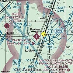
| Sectional chart |
|---|
|
| Airport distance calculator |
|---|
|
|
| Sunrise and sunset |
|---|
|
Times for 28-May-2026
| | Local
(UTC-5) | | Zulu
(UTC) |
|---|
| Morning civil twilight | | 04:55 | | 09:55 |
| Sunrise | | 05:27 | | 10:27 |
| Sunset | | 20:12 | | 01:12 |
| Evening civil twilight | | 20:44 | | 01:44 |
|
| Current date and time |
|---|
| Zulu (UTC) | 28-May-2026 05:00:15 |
|---|
| Local (UTC-5) | 28-May-2026 00:00:15 |
|---|
|
| METAR |
|---|
KTIP
9nm S | 280435Z AUTO 03004KT 10SM CLR 21/16 A3003 RMK AO2 T02070164
|
|
| TAF |
|---|
KCMI
26nm S | 271725Z 2718/2818 05008KT P6SM SCT017 BKN035 TEMPO 2718/2720 BKN020 FM272000 06007KT P6SM SCT025 BKN050 FM280200 06006KT P6SM FEW050 SCT250 FM281100 04010KT P6SM FEW070 SCT250
|
|
| NOTAMs |
|---|
NOTAMs are issued by the DoD/FAA and will open in a separate window not controlled by AirNav.
|
|

