FAA INFORMATION EFFECTIVE 14 MAY 2026
Location
| FAA Identifier: | C16 |
| Lat/Long: | 40-08-47.0392N 088-11-54.5553W
40-08.783987N 088-11.909255W
40.1463998,-88.1984876
(estimated) |
| Elevation: | 735 ft. / 224.0 m (surveyed) |
| Variation: | 02E (1965) |
| From city: | 1 mile N of URBANA, IL |
| Time zone: | UTC -5 (UTC -6 during Standard Time) |
| Zip code: | 61802 |
Airport Operations
| Airport use: | Open to the public |
| Activation date: | 03/1941 |
| Control tower: | no |
| ARTCC: | CHICAGO CENTER |
| FSS: | SAINT LOUIS FLIGHT SERVICE STATION |
| NOTAMs facility: | STL (NOTAM-D service available) |
| Attendance: | DAWN-DUSK |
| Wind indicator: | lighted |
| Segmented circle: | yes |
| Lights: | SS-SR |
Airport Communications
| CTAF/UNICOM: | 122.8 |
| CHAMPAIGN APPROACH: | 121.35 |
| CHAMPAIGN DEPARTURE: | 121.35 |
| WX ASOS at CMI (7 nm SW): | PHONE 217-355-4072 |
| WX AWOS-3 at TIP (9 nm N): | 119.025 (217-892-4999) |
- APCH/DEP SVC PRVDD BY CHICAGO ARTCC ON REMOTED CHAMPAIGN APCH CTL FREQS 121.35 & 353.95 (DANVILLE RCAG) WHEN CHAMPAIGN APCH CTL CLSD.
- COMMUNICATIONS PRVDD BY ST. LOUIS RADIO ON FREQS 122.4 (CHAMPAIGN/URBANA RCO) AND 122.1R (CHAMPAIGN RCO)
Nearby radio navigation aids
| VOR radial/distance | | VOR name | | Freq | | Var |
|---|
| CMIr025/7.6 | | CHAMPAIGN VORTAC | | 115.75 | | 03E |
| RBSr181/26.2 | | ROBERTS VOR/DME | | 116.80 | | 02E |
| AXCr048/39.0 | | ADDERS VORTAC | | 117.20 | | 03E |
| NDB name | | Hdg/Dist | | Freq | | Var | | ID |
|---|
| VEALS | | 359/10.8 | | 407 | | 03W | | CM | -.-. -- |
Airport Services
| Fuel available: | 100LL JET-A |
| Parking: | hangars and tiedowns |
| Airframe service: | NONE |
| Powerplant service: | NONE |
| Bottled oxygen: | NONE |
| Bulk oxygen: | NONE |
Runway Information
Runway 9/27
| Dimensions: | 4001 x 55 ft. / 1220 x 17 m |
| Surface: | concrete, in fair condition |
| Runway edge lights: | medium intensity |
| RUNWAY 9 | | RUNWAY 27 |
| Latitude: | 40-08.699975N | | 40-08.706668N |
| Longitude: | 088-12.451585W | | 088-11.593055W |
| Elevation: | 734.6 ft. | | 724.3 ft. |
| Traffic pattern: | left | | right |
| Runway heading: | 087 magnetic, 089 true | | 267 magnetic, 269 true |
| Markings: | basic, in fair condition | | basic, in fair condition |
| Touchdown point: | yes, no lights | | no, no lights |
Runway 18/36
| Dimensions: | 3654 x 140 ft. / 1114 x 43 m |
| Surface: | turf, in fair condition |
| RUNWAY 18 | | RUNWAY 36 |
| Latitude: | 40-09.173185N | | 40-08.571437N |
| Longitude: | 088-11.790122W | | 088-11.780785W |
| Elevation: | 728.0 ft. | | 731.3 ft. |
| Traffic pattern: | left | | left |
| Runway heading: | 177 magnetic, 179 true | | 357 magnetic, 359 true |
| Displaced threshold: | no | | 318 ft. |
| Obstructions: | none | | 38 ft. pole, 416 ft. from runway, 101 ft. right of centerline, 10:1 slope to clear
APPCH RATIO IS 20:1 TO THE DSPLCD THLD. |
Airport Ownership and Management from official FAA records
| Ownership: | Privately-owned |
| Owner: | FRASCA AIR SERVICE INC
1402 E AIRPORT ROAD
URBANA, IL 61801
Phone 217-367-8441 |
| Manager: | TOM FRASCA
1402 E ARPT RD
URBANA, IL 61801
Phone 217-367-8441
EMAIL ADDRESS: TFRASCA@FRASCA.COM (ALL LOWER CASE) |
Additional Remarks
| - | FOR CD CTC CHAMPAIGN APCH AT 217-355-4071, WHEN APCH CLSD CTC CHICAGO ARTCC AT 630-906-8921 |
Instrument Procedures
NOTE: All procedures below are presented as PDF files. If you need a reader for these files, you should download the free Adobe Reader.NOT FOR NAVIGATION. Please procure official charts for flight.
FAA instrument procedures published for use from 14 May 2026 at 0901Z to 11 June 2026 at 0900Z.
IAPs - Instrument Approach Procedures |
|---|
| VOR-A | |
download (211KB) |
Other nearby airports with instrument procedures:
KCMI - University of Illinois/Willard Airport (7 nm SW)
KTIP - Rantoul National Aviation Center Airport-Frank Elliott Field (9 nm N)
1C1 - Paxton Airport (18 nm N)
KDNV - Vermilion Regional Airport (28 nm E)
KDEC - Decatur Airport (36 nm SW)
|
|

Road maps at:
MapQuest
Bing
Google
| Aerial photo |
|---|
WARNING: Photo may not be current or correct
 Photo by Stuart C. King
Photo taken 07-Sep-2005
Photo by Stuart C. King
Photo taken 07-Sep-2005
Do you have a better or more recent aerial photo of Frasca Field Airport that you would like to share? If so, please send us your photo.
|
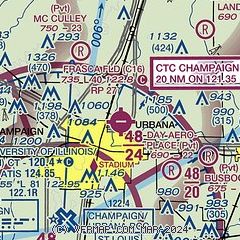
| Sectional chart |
|---|
|
| Airport distance calculator |
|---|
|
|
| Sunrise and sunset |
|---|
|
Times for 26-May-2026
| | Local
(UTC-5) | | Zulu
(UTC) |
|---|
| Morning civil twilight | | 04:58 | | 09:58 |
| Sunrise | | 05:30 | | 10:30 |
| Sunset | | 20:10 | | 01:10 |
| Evening civil twilight | | 20:42 | | 01:42 |
|
| Current date and time |
|---|
| Zulu (UTC) | 26-May-2026 11:20:29 |
|---|
| Local (UTC-5) | 26-May-2026 06:20:29 |
|---|
|
| METAR |
|---|
KCMI
7nm SW | 261053Z 07007KT 10SM CLR 16/09 A3007 RMK AO2 SLP178 T01610094
|
KTIP
9nm N | 261055Z AUTO 07004KT 10SM CLR 15/10 A3008 RMK AO2 T01480095
|
|
| TAF |
|---|
KCMI
7nm SW | 260520Z 2606/2706 10007KT P6SM OVC300 FM260800 VRB04KT P6SM BKN300 FM261500 10009KT P6SM OVC250
|
|
| NOTAMs |
|---|
NOTAMs are issued by the DoD/FAA and will open in a separate window not controlled by AirNav.
|
|

