FAA INFORMATION EFFECTIVE 09 JULY 2026
Location
| FAA Identifier: | TIP |
| Lat/Long: | 40-17-36.8000N 088-08-32.6000W
40-17.613333N 088-08.543333W
40.2935556,-88.1423889
(estimated) |
| Elevation: | 737.9 ft. / 224.9 m (surveyed) |
| Variation: | 01W (1995) |
| Time zone: | UTC -5 (UTC -6 during Standard Time) |
| Zip code: | 61866 |
Airport Operations
| Airport use: | Open to the public |
| Activation date: | 08/1993 |
| Control tower: | no |
| ARTCC: | CHICAGO CENTER |
| FSS: | SAINT LOUIS FLIGHT SERVICE STATION |
| NOTAMs facility: | TIP (NOTAM-D service available) |
| Attendance: | MON-FRI 0700-1600 |
| Wind indicator: | yes |
| Segmented circle: | yes |
| Lights: | TO INCR INTST & ACTVT MIRL RYS 09/27 & 18/36, REILS RYS 09/27 - CTAF. PAPI RY 09 & 27 OPR CONTINUOUSLY. |
| Beacon: | white-green (lighted land airport)
Operates sunset to sunrise. |
Airport Communications
| CTAF/UNICOM: | 123.0 |
| WX AWOS-3: | 119.025 (217-892-4999) |
| CHAMPAIGN APPROACH: | 121.35 |
| CHAMPAIGN DEPARTURE: | 121.35 |
| WX ASOS at CMI (16 nm S): | PHONE 217-355-4072 |
- APCH/DEP SVC PRVDD BY CHICAGO ARTCC ON REMOTED CHAMPAIGN APCH CTL FREQS 121.35 & 353.95 (DANVILLE RCAG) WHEN CHAMPAIGN APCH CTL CLSD.
Nearby radio navigation aids
| VOR radial/distance | | VOR name | | Freq | | Var |
|---|
| CMIr019/16.7 | | CHAMPAIGN VORTAC | | 115.75 | | 03E |
| RBSr175/17.3 | | ROBERTS VOR/DME | | 116.80 | | 02E |
Airport Services
| Fuel available: | 100LL JET-A
100LL:FOR FUEL AFTER HRS CALL PHONE NUMBER POSTED ON SITE. |
| Parking: | hangars |
| Airframe service: | NONE |
| Powerplant service: | NONE |
| Bottled oxygen: | NONE |
| Bulk oxygen: | NONE |
Runway Information
Runway 9/27
| Dimensions: | 5001 x 75 ft. / 1524 x 23 m |
| Surface: | asphalt, in good condition |
| Runway edge lights: | medium intensity |
| RUNWAY 9 | | RUNWAY 27 |
| Latitude: | 40-17.518548N | | 40-17.524390N |
| Longitude: | 088-08.993698W | | 088-07.918150W |
| Elevation: | 735.2 ft. | | 728.6 ft. |
| Traffic pattern: | right | | left |
| Runway heading: | 091 magnetic, 090 true | | 271 magnetic, 270 true |
| Markings: | nonprecision, in fair condition | | nonprecision, in fair condition |
| Visual slope indicator: | 4-light PAPI on left (3.00 degrees glide path) | | 4-light PAPI on left (3.00 degrees glide path) |
| Runway end identifier lights: | yes | | yes |
| Touchdown point: | yes, no lights | | yes, no lights |
Runway 18/36
| Dimensions: | 4894 x 75 ft. / 1492 x 23 m |
| Surface: | asphalt, in good condition |
| Runway edge lights: | medium intensity |
| RUNWAY 18 | | RUNWAY 36 |
| Latitude: | 40-18.110090N | | 40-17.304070N |
| Longitude: | 088-08.631663W | | 088-08.631173W |
| Elevation: | 737.4 ft. | | 733.3 ft. |
| Traffic pattern: | left | | right |
| Runway heading: | 181 magnetic, 180 true | | 001 magnetic, 360 true |
| Markings: | nonprecision, in fair condition | | nonprecision, in fair condition |
| Touchdown point: | yes, no lights | | yes, no lights |
Airport Ownership and Management from official FAA records
| Ownership: | Publicly-owned |
| Owner: | VILLAGE OF RANTOUL
333 SOUTH TANNER STREET, PO BOX 38
RANTOUL, IL 61866
Phone 217-892-6800 |
| Manager: | BOB COVERDILL
333 S. TANNER, P.O BOX 38
RANTOUL, IL 61866-0038
Phone 217-892-6895 |
Additional Remarks
| - | FBO OPNS MON-FRI 0700-1600. FBO SVC CLSD SAT+SUN UNLESS ADVN COORDINATION IS MADE. |
| - | DEER & BIRDS ON AND INVOF ARPT. SEASONAL MOWING OPS ADJ TO RYS & TWYS. |
| - | TWY 35 FT WIDE IN MOST PLACES. 48 HRS PPR FOR ACFT WITH SINGLE WHEEL LOAD GREATER THAN 15,000 LBS. |
| - | FOR CD CTC CHAMPAIGN APCH AT 217-355-4071, WHEN APCH CLSD CTC CHICAGO ARTCC AT 630-906-8921 |
Instrument Procedures
NOTE: All procedures below are presented as PDF files. If you need a reader for these files, you should download the free Adobe Reader.NOT FOR NAVIGATION. Please procure official charts for flight.
FAA instrument procedures published for use from 09 July 2026 at 0901Z to 06 August 2026 at 0900Z.
IAPs - Instrument Approach Procedures |
|---|
| RNAV (GPS) RWY 09 | |
download (226KB) |
| RNAV (GPS) RWY 18 | |
download (229KB) |
| RNAV (GPS) RWY 27 | |
download (217KB) |
| RNAV (GPS) RWY 36 | |
download (229KB) |
| NOTE: Special Alternate Minimums apply | |
download (162KB) |
| NOTE: Special Take-Off Minimums/Departure Procedures apply | |
download (518KB) |
Other nearby airports with instrument procedures:
C16 - Frasca Field Airport (9 nm S)
1C1 - Paxton Airport (9 nm N)
KCMI - University of Illinois/Willard Airport (16 nm S)
KDNV - Vermilion Regional Airport (26 nm E)
KBMI - Central Illinois Regional Airport/Bloomington-Normal (37 nm W)
|
|

Road maps at:
MapQuest
Bing
Google
| Aerial photo |
|---|
WARNING: Photo may not be current or correct

Do you have a better or more recent aerial photo of Rantoul National Aviation Center Airport-Frank Elliott Field that you would like to share? If so, please send us your photo.
|
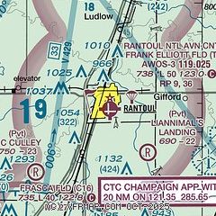
| Sectional chart |
|---|
|
CAUTION: Diagram may not be current

| Airport distance calculator |
|---|
|
|
| Sunrise and sunset |
|---|
|
Times for 24-Jul-2026
| | Local
(UTC-5) | | Zulu
(UTC) |
|---|
| Morning civil twilight | | 05:13 | | 10:13 |
| Sunrise | | 05:44 | | 10:44 |
| Sunset | | 20:14 | | 01:14 |
| Evening civil twilight | | 20:45 | | 01:45 |
|
| Current date and time |
|---|
| Zulu (UTC) | 24-Jul-2026 12:45:23 |
|---|
| Local (UTC-5) | 24-Jul-2026 07:45:23 |
|---|
|
| METAR |
|---|
KCMI
17nm S | 241153Z 07005KT 10SM CLR 16/13 A3016 RMK AO2 SLP210 T01560133 10167 20150 55001
|
|
| TAF |
|---|
KCMI
17nm S | 241120Z 2412/2512 16005KT P6SM SCT050 BKN120 FM251000 17003KT P6SM SCT020 BKN050
|
|
| NOTAMs |
|---|
NOTAMs are issued by the DoD/FAA and will open in a separate window not controlled by AirNav.
|
|


