FAA INFORMATION EFFECTIVE 16 APRIL 2026
Location
| FAA Identifier: | 1D1 |
| Lat/Long: | 45-13-49.8000N 096-33-57.9000W
45-13.830000N 096-33.965000W
45.2305000,-96.5660833
(estimated) |
| Elevation: | 1117.8 ft. / 340.7 m (surveyed) |
| Variation: | 05E (2000) |
| From city: | 3 miles E of MILBANK, SD |
| Time zone: | UTC -5 (UTC -6 during Standard Time) |
| Zip code: | 57252 |
Airport Operations
| Airport use: | Open to the public |
| Activation date: | 06/1946 |
| Control tower: | no |
| ARTCC: | MINNEAPOLIS CENTER |
| FSS: | HURON FLIGHT SERVICE STATION |
| NOTAMs facility: | HON (NOTAM-D service available) |
| Attendance: | MON-FRI 0900-1500
UNATNDD HOLS. |
| Wind indicator: | lighted |
| Segmented circle: | no |
| Lights: | ACTVT MIRL RY 13/31 & PAPI RY 31 - CTAF. |
| Beacon: | white-green (lighted land airport)
Operates sunset to sunrise. |
Airport Communications
| CTAF/UNICOM: | 122.8 |
| WX AWOS-3P: | 118.9 (605-438-2088) |
| WX AWOS-3 at VVV (7 nm NE): | 119.225 (320-839-2363) |
- AUTOMATED UNICOM.
- APCH/DEP SVC PRVDD BY MINNEAPOLIS ARTCC ON FREQS 128.5/306.2 (WATERTOWN RCAG).
Nearby radio navigation aids
| VOR radial/distance | | VOR name | | Freq | | Var |
|---|
| MOXr226/32.2 | | MORRIS VOR/DME | | 109.60 | | 05E |
| MVEr288/39.3 | | MONTEVIDEO VOR/DME | | 111.60 | | 05E |
Airport Services
| Fuel available: | 100LL
100LL:FUEL AVBL 24 HRS WITH CREDIT CARD. |
| Parking: | hangars and tiedowns |
| Airframe service: | MINOR |
| Powerplant service: | MINOR |
| Bottled oxygen: | NONE |
| Bulk oxygen: | NONE |
Runway Information
Runway 13/31
| Dimensions: | 4000 x 60 ft. / 1219 x 18 m |
| Surface: | concrete, in excellent condition |
| Weight bearing capacity: | |
| Runway edge lights: | medium intensity |
| RUNWAY 13 | | RUNWAY 31 |
| Latitude: | 45-14.162698N | | 45-13.679437N |
| Longitude: | 096-34.213372W | | 096-33.581085W |
| Elevation: | 1113.8 ft. | | 1114.9 ft. |
| Traffic pattern: | left | | left |
| Runway heading: | 132 magnetic, 137 true | | 312 magnetic, 317 true |
| Markings: | nonprecision, in good condition | | nonprecision, in good condition |
| Visual slope indicator: | 2-light PAPI on left (3.00 degrees glide path) | | 2-light PAPI on left (3.00 degrees glide path) |
| Runway end identifier lights: | no | | no |
| Touchdown point: | yes, no lights | | yes, no lights |
| Obstructions: | none | | 15 ft. road, 525 ft. from runway, 21:1 slope to clear |
Runway 7/25
| Dimensions: | 3586 x 155 ft. / 1093 x 47 m |
| Surface: | turf, in good condition |
| Runway edge markings: | RWY 07/25 MKD WITH WHITE & BLACK PLASTIC MKR CONES. |
| Operational restrictions: | RY 07/25 CLSD WINTER MONTHS. |
| RUNWAY 7 | | RUNWAY 25 |
| Latitude: | 45-13.634802N | | 45-13.823818N |
| Longitude: | 096-34.436807W | | 096-33.645782W |
| Elevation: | 1112.1 ft. | | 1113.4 ft. |
| Traffic pattern: | left | | left |
| Runway heading: | 066 magnetic, 071 true | | 246 magnetic, 251 true |
| Markings: | none | | none |
| Runway end identifier lights: | no | | no |
| Touchdown point: | yes, no lights | | yes, no lights |
| Obstructions: | 5 ft. fence, 200 ft. from runway, 40:1 slope to clear | | none |
Airport Ownership and Management from official FAA records
| Ownership: | Publicly-owned |
| Owner: | CITY OF MILBANK
1001 E 4TH AVE, SUITE 301
MILBANK, SD 57252
Phone 605-432-9575 |
| Manager: | STEVE PENDERGRASS
1001 E. 4TH AVE., #301
MILBANK, SD 57252-6034
Phone 605-432-9575 |
Additional Remarks
| - | RY 31 +4' FENCE 600' FM THR & 10' R FM CNTRLN & 350' FM THR & 250' R FM CNTRLN. |
| - | RY 13 +4' FENCE 450' FM THR. |
| - | ULTRALIGHT ACT ON AND INVOF ARPT. |
| - | WATERFOWL ON AND INVOF ARPT. |
| - | FOR CD CTC MINNEAPOLIS ARTCC AT 651-463-5588. |
Instrument Procedures
NOTE: All procedures below are presented as PDF files. If you need a reader for these files, you should download the free Adobe Reader.NOT FOR NAVIGATION. Please procure official charts for flight.
FAA instrument procedures published for use from 16 April 2026 at 0901Z to 14 May 2026 at 0900Z.
IAPs - Instrument Approach Procedures |
|---|
| RNAV (GPS) RWY 31 **CHANGED** | |
download (206KB) |
| NOTE: Special Alternate Minimums apply | |
download (176KB) |
| NOTE: Special Take-Off Minimums/Departure Procedures apply | |
download (409KB) |
Other nearby airports with instrument procedures:
KVVV - Ortonville Municipal Airport/Martinson Field (7 nm NE)
KDXX - Lac Qui Parle County Airport (22 nm SE)
KAQP - Appleton Municipal Airport (24 nm E)
KATY - Watertown Regional Airport (31 nm SW)
8D3 - Sisseton Municipal Airport (32 nm NW)
|
|

Road maps at:
MapQuest
Bing
Google
| Aerial photo |
|---|
WARNING: Photo may not be current or correct
 Photo by Steve Hamilton
Photo taken 28-Oct-2008
Photo by Steve Hamilton
Photo taken 28-Oct-2008
Do you have a better or more recent aerial photo of Milbank Municipal Airport that you would like to share? If so, please send us your photo.
|
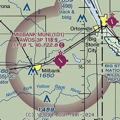
| Sectional chart |
|---|
|
| Airport distance calculator |
|---|
|
|
| Sunrise and sunset |
|---|
|
Times for 10-May-2026
| | Local
(UTC-5) | | Zulu
(UTC) |
|---|
| Morning civil twilight | | 05:30 | | 10:30 |
| Sunrise | | 06:03 | | 11:03 |
| Sunset | | 20:42 | | 01:42 |
| Evening civil twilight | | 21:16 | | 02:16 |
|
| Current date and time |
|---|
| Zulu (UTC) | 11-May-2026 04:24:41 |
|---|
| Local (UTC-5) | 10-May-2026 23:24:41 |
|---|
|
| METAR |
|---|
KVVV
8nm NE | 110355Z AUTO 00000KT 10SM CLR 08/M01 A3023 RMK AO2
|
|
| TAF |
|---|
KATY
32nm SW | 101720Z 1018/1118 35009KT P6SM SKC FM110000 35008KT P6SM SKC FM110200 VRB04KT P6SM SKC FM111100 15007KT P6SM FEW100 FM111600 16013G22KT P6SM FEW050 FEW190
|
|
| NOTAMs |
|---|
NOTAMs are issued by the DoD/FAA and will open in a separate window not controlled by AirNav.
|
|

