FAA INFORMATION EFFECTIVE 09 JULY 2026
Location
| FAA Identifier: | ATY |
| Lat/Long: | 44-54-50.3000N 097-09-17.0000W
44-54.838333N 097-09.283333W
44.9139722,-97.1547222
(estimated) |
| Elevation: | 1749.3 ft. / 533.2 m (surveyed) |
| Variation: | 06E (1985) |
| From city: | 2 miles NW of WATERTOWN, SD |
| Time zone: | UTC -5 (UTC -6 during Standard Time) |
| Zip code: | 57201 |
Airport Operations
| Airport use: | Open to the public |
| Activation date: | 12/1937 |
| Control tower: | no |
| ARTCC: | MINNEAPOLIS CENTER |
| FSS: | HURON FLIGHT SERVICE STATION |
| NOTAMs facility: | ATY (NOTAM-D service available) |
| Attendance: | 0430-2030 |
| Wind indicator: | lighted |
| Segmented circle: | yes |
| Lights: | ACTVT MALSR RWY 35; PAPI RWY 12, 17, 30, & 35; HIRL RWY 17/35; MIRL RWY 12/30; REIL RWY 12, 17, & 30 - CTAF. |
| Beacon: | white-green (lighted land airport)
Operates sunset to sunrise. |
| Landing fee: | yes |
| Fire and rescue: | ARFF index A |
| Airline operations: | PPR 48 HRS UNSKED ACR OPNS WITH MORE THAN 30 PSGR SEATS CALL AMGR 605 882-6209. |
Airport Communications
| CTAF/UNICOM: | 123.05 |
| WX ASOS: | 126.625 (605-882-0578) |
- APCH/DEP SVC PRVDD BY MINNEAPOLIS ARTCC ON FREQS 128.5/306.2 (WATERTOWN RCAG).
Airport Services
| Fuel available: | 100LL JET-A |
| Parking: | hangars and tiedowns |
| Airframe service: | MAJOR |
| Powerplant service: | MAJOR |
Runway Information
Runway 12/30
| Dimensions: | 6898 x 100 ft. / 2103 x 30 m |
| Surface: | concrete/grooved, in excellent condition |
| Weight bearing capacity: | | Single wheel: | 80.0 | | Double wheel: | 97.0 | | Double tandem: | 160.0 |
|
| Runway edge lights: | medium intensity |
| RUNWAY 12 | | RUNWAY 30 |
| Latitude: | 44-55.332253N | | 44-54.688733N |
| Longitude: | 097-10.158258W | | 097-08.842295W |
| Elevation: | 1748.4 ft. | | 1732.7 ft. |
| Traffic pattern: | left | | left |
| Runway heading: | 119 magnetic, 125 true | | 299 magnetic, 305 true |
| Declared distances: | TORA:6899 TODA:6899 ASDA:6899 LDA:6899 | | TORA:6899 TODA:6899 ASDA:6899 LDA:6899 |
| Markings: | nonprecision, in good condition | | nonprecision, in good condition |
| Visual slope indicator: | 4-light PAPI on left (3.00 degrees glide path) | | 4-light PAPI on left (3.00 degrees glide path) |
| Runway end identifier lights: | yes | | yes |
| Touchdown point: | yes, no lights | | yes, no lights |
| Obstructions: | none | | 51 ft. tree, 2013 ft. from runway, 329 ft. left of centerline, 35:1 slope to clear |
Runway 17/35
| Dimensions: | 6893 x 100 ft. / 2101 x 30 m |
| Surface: | concrete/grooved, in good condition |
| Weight bearing capacity: | | Single wheel: | 120.0 | | Double wheel: | 177.0 | | Double tandem: | 301.0 |
|
| Runway edge lights: | high intensity |
| RUNWAY 17 | | RUNWAY 35 |
| Latitude: | 44-55.233550N | | 44-54.099257N |
| Longitude: | 097-09.063513W | | 097-09.070270W |
| Elevation: | 1740.7 ft. | | 1742.9 ft. |
| Traffic pattern: | left | | left |
| Runway heading: | 174 magnetic, 180 true | | 354 magnetic, 000 true |
| Declared distances: | TORA:6894 TODA:6894 ASDA:6894 LDA:6894 | | TORA:6894 TODA:6894 ASDA:6894 LDA:6894 |
| Markings: | precision, in good condition | | precision, in good condition |
| Visual slope indicator: | 4-light PAPI on left (3.00 degrees glide path) | | 4-light PAPI on left (3.00 degrees glide path) |
| Approach lights: | | | MALSR: 1,400 foot medium intensity approach lighting system with runway alignment indicator lights |
| Runway end identifier lights: | yes | | |
| Touchdown point: | yes, no lights | | yes, no lights |
| Instrument approach: | | | ILS/DME |
| Obstructions: | none | | 83 ft. bldg, lighted, 3775 ft. from runway, 412 ft. left of centerline, 43:1 slope to clear |
Airport Ownership and Management from official FAA records
| Ownership: | Publicly-owned |
| Owner: | CITY OF WATERTOWN
P.O. BOX 910
WATERTOWN, SD 57201
Phone 605-882-6209 |
| Manager: | IAN MERIWETHER-CHALFANT
550 E AIRPORT DRIVE
WATERTOWN, SD 57201
Phone 605-753-9357
605-753-9357 |
Additional Remarks
| A39-12/30 | PCR VALUE: 509/R/D/W/T |
| A39-17/35 | PCR VALUE: 491/R/D/W/T |
| - | GULLS & GEESE ON & INVOF ARPT APR-NOV. |
| - | GLDR OPNS PROHIBITED ON TWY D. |
| - | GLIDER OPNS APR THRU SEP. |
| - | ANNUALLY APRIL- SEPT HAY CUTTING OPNS IN PROGRESS; FARMING EQUIP MAY BE IN APCHS. |
| - | ARPT SFC COND NOT MONITORED 2230-0430. |
| - | FOR CD IF UNA TO CTC ON FSS FREQ, CTC MINNEAPOLIS ARTCC AT 651-463-5588. |
Instrument Procedures
NOTE: All procedures below are presented as PDF files. If you need a reader for these files, you should download the free Adobe Reader.NOT FOR NAVIGATION. Please procure official charts for flight.
FAA instrument procedures published for use from 09 July 2026 at 0901Z to 06 August 2026 at 0900Z.
IAPs - Instrument Approach Procedures |
|---|
| ILS OR LOC RWY 35 | |
download (223KB) |
| RNAV (GPS) RWY 12 | |
download (194KB) |
| RNAV (GPS) RWY 17 | |
download (196KB) |
| RNAV (GPS) RWY 30 | |
download (202KB) |
| RNAV (GPS) RWY 35 | |
download (206KB) |
| NOTE: Special Alternate Minimums apply | |
download (176KB) |
| NOTE: Special Take-Off Minimums/Departure Procedures apply | |
download (233KB) |
Other nearby airports with instrument procedures:
8D7 - Clark County Airport (24 nm W)
1D1 - Milbank Municipal Airport (31 nm NE)
6E5 - Wilder Airport (34 nm SW)
KVVV - Ortonville Municipal Airport/Martinson Field (39 nm NE)
KBKX - Brookings Regional Airport (39 nm S)
|
|

Road maps at:
MapQuest
Bing
Google
| Aerial photo |
|---|
WARNING: Photo may not be current or correct
 Photo by Steve Hamilton
Photo taken 28-Oct-2008
Photo by Steve Hamilton
Photo taken 28-Oct-2008
Do you have a better or more recent aerial photo of Watertown Regional Airport that you would like to share? If so, please send us your photo.
|
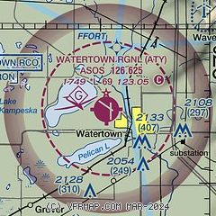
| Sectional chart |
|---|
|
| Airport distance calculator |
|---|
|
|
| Sunrise and sunset |
|---|
|
Times for 13-Jul-2026
| | Local
(UTC-5) | | Zulu
(UTC) |
|---|
| Morning civil twilight | | 05:20 | | 10:20 |
| Sunrise | | 05:56 | | 10:56 |
| Sunset | | 21:13 | | 02:13 |
| Evening civil twilight | | 21:49 | | 02:49 |
|
| Current date and time |
|---|
| Zulu (UTC) | 13-Jul-2026 19:39:58 |
|---|
| Local (UTC-5) | 13-Jul-2026 14:39:58 |
|---|
|
| METAR |
|---|
| KATY | 131853Z AUTO 21018KT 10SM CLR 31/19 A3014 RMK AO2 SLP191 T03060194
|
|
| TAF |
|---|
| KATY | 131721Z 1318/1418 21015G22KT P6SM SKC FM140200 19009KT P6SM SKC FM141500 22010G18KT P6SM SKC
|
|
| NOTAMs |
|---|
NOTAMs are issued by the DoD/FAA and will open in a separate window not controlled by AirNav.
|
|


