FAA INFORMATION EFFECTIVE 16 APRIL 2026
Location
| FAA Identifier: | 8D3 |
| Lat/Long: | 45-40-10.2990N 096-59-36.9080W
45-40.171650N 096-59.615133W
45.6695275,-96.9935856
(estimated) |
| Elevation: | 1162.2 ft. / 354.2 m (surveyed) |
| Variation: | 03E (2020) |
| From city: | 3 miles E of SISSETON, SD |
| Time zone: | UTC -5 (UTC -6 during Standard Time) |
| Zip code: | 57262 |
Airport Operations
| Airport use: | Open to the public |
| Activation date: | 04/1946 |
| Control tower: | no |
| ARTCC: | MINNEAPOLIS CENTER |
| FSS: | HURON FLIGHT SERVICE STATION |
| NOTAMs facility: | HON (NOTAM-D service available) |
| Attendance: | UNATNDD |
| Wind indicator: | lighted |
| Segmented circle: | no |
| Lights: | ACTVT PAPI RWY 16 & 34; MIRL RWY 16/34 - CTAF. |
| Beacon: | white-green (lighted land airport)
Operates sunset to sunrise. |
Airport Communications
| CTAF: | 122.9 |
| WX AWOS-3 at ETH (20 nm E): | 118.775 (320-563-4975) |
- APCH/DEP SVC PRVDD BY MINNEAPOLIS ARTCC (ZMP) ON FREQS 128.5/306.2 (WATERTOWN RCAG).
Airport Services
| Fuel available: | 100LL
100LL:FUEL AVBL 24 HRS WITH CREDIT CARD. |
| Parking: | tiedowns |
| Airframe service: | NONE |
| Powerplant service: | NONE |
| Bottled oxygen: | NONE |
| Bulk oxygen: | NONE |
Runway Information
Runway 16/34
| Dimensions: | 3400 x 60 ft. / 1036 x 18 m |
| Surface: | asphalt, in excellent condition |
| Weight bearing capacity: | |
| Runway edge lights: | medium intensity |
| RUNWAY 16 | | RUNWAY 34 |
| Latitude: | 45-40.405720N | | 45-39.859733N |
| Longitude: | 096-59.716223W | | 096-59.542802W |
| Elevation: | 1159.6 ft. | | 1161.8 ft. |
| Traffic pattern: | left | | left |
| Runway heading: | 164 magnetic, 167 true | | 344 magnetic, 347 true |
| Markings: | nonprecision, in good condition | | nonprecision, in good condition |
| Visual slope indicator: | 2-light PAPI on left (3.00 degrees glide path) | | 2-light PAPI on left (3.00 degrees glide path) |
| Runway end identifier lights: | | | no |
| Touchdown point: | yes, no lights | | yes, no lights |
| Obstructions: | 12 ft. road, 500 ft. from runway, 25:1 slope to clear | | 4 ft. fence, 285 ft. from runway, 21:1 slope to clear |
Runway 4/22
| Dimensions: | 1914 x 150 ft. / 583 x 46 m |
| Surface: | turf, in fair condition |
| Runway edge markings: | RY 04/22 MARKED WITH BLACK AND WHITE CONES. |
| Operational restrictions: | RY 04/22 CLSD WINTER MONTHS. |
| RUNWAY 4 | | RUNWAY 22 |
| Latitude: | 45-40.128587N | | 45-40.353023N |
| Longitude: | 096-59.747100W | | 096-59.432063W |
| Elevation: | 1158.8 ft. | | 1147.1 ft. |
| Traffic pattern: | left | | left |
| Runway heading: | 042 magnetic, 045 true | | 222 magnetic, 225 true |
| Markings: | , in fair condition | | , in fair condition |
| Runway end identifier lights: | no | | no |
| Touchdown point: | yes, no lights | | yes, no lights |
| Obstructions: | 42 ft. pole, 1080 ft. from runway, 75 ft. left of centerline, 25:1 slope to clear | | 55 ft. tree, 1277 ft. from runway, 175 ft. left of centerline, 23:1 slope to clear |
Airport Ownership and Management from official FAA records
| Ownership: | Publicly-owned |
| Owner: | CITY OF SISSETON
406 2ND AVE.
SISSETON, SD 57262
Phone 605-698-3391 |
| Manager: | CITY OF SISSETON
513 VETERAN AVE EAST
SISSETON, SD 57262
Phone 605-698-3391 |
Additional Remarks
| - | RY 04 +4' FENCE 300' FM THR & 175' FM THR & 125' FM CNTRLN. |
| - | RY 16 +4' FENCE 460' FM THR. |
| - | RY 22 +4' FENCE 300' FM THR & 85' L FM CNTRLN & 240' FM THR 125' L FM CNTRLN. |
| - | RY 34 +4' FENCE 285' FM THR. |
| - | WATERFOWL AND GULLS AROUND AND INVOF ARPT. |
| - | FOR CD CTC MINNEAPOLIS ARTCC AT 651-463-5588. |
Instrument Procedures
NOTE: All procedures below are presented as PDF files. If you need a reader for these files, you should download the free Adobe Reader.NOT FOR NAVIGATION. Please procure official charts for flight.
FAA instrument procedures published for use from 16 April 2026 at 0901Z to 14 May 2026 at 0900Z.
IAPs - Instrument Approach Procedures |
|---|
| RNAV (GPS) RWY 16 | |
download (219KB) |
| RNAV (GPS) RWY 34 | |
download (225KB) |
| NOTE: Special Take-Off Minimums/Departure Procedures apply | |
download (237KB) |
Other nearby airports with instrument procedures:
KETH - Wheaton Municipal Airport (20 nm E)
1D1 - Milbank Municipal Airport (32 nm SE)
KVVV - Ortonville Municipal Airport/Martinson Field (32 nm SE)
KBTN - Britton Municipal Airport (33 nm W)
KBWP - Harry Stern Airport (38 nm NE)
|
|

Road maps at:
MapQuest
Bing
Google
| Aerial photo |
|---|
WARNING: Photo may not be current or correct
 Photo by Steve Hamilton
Photo taken 28-Oct-2008
Photo by Steve Hamilton
Photo taken 28-Oct-2008
Do you have a better or more recent aerial photo of Sisseton Municipal Airport that you would like to share? If so, please send us your photo.
|
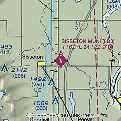
| Sectional chart |
|---|
|
| Airport distance calculator |
|---|
|
|
| Sunrise and sunset |
|---|
|
Times for 29-Apr-2026
| | Local
(UTC-5) | | Zulu
(UTC) |
|---|
| Morning civil twilight | | 05:47 | | 10:47 |
| Sunrise | | 06:20 | | 11:20 |
| Sunset | | 20:31 | | 01:31 |
| Evening civil twilight | | 21:04 | | 02:04 |
|
| Current date and time |
|---|
| Zulu (UTC) | 29-Apr-2026 19:50:26 |
|---|
| Local (UTC-5) | 29-Apr-2026 14:50:26 |
|---|
|
| METAR |
|---|
| K8D3 | 291856Z AUTO 12/M01 A3005 RMK AO1 SLP183 T01221006
|
|
| TAF |
|---|
KATY
47nm S | 291720Z 2918/3018 30010G20KT P6SM FEW045 SCT070 TEMPO 2919/2921 -SHRA BKN045 FM292200 32009KT P6SM FEW040 SCT070 PROB30 2923/3001 6SM -TSRA BKN040CB FM300100 36008KT P6SM SCT040 BKN080 FM300300 03006KT P6SM SCT090 FM301500 35007KT P6SM SCT100
|
|
| NOTAMs |
|---|
NOTAMs are issued by the DoD/FAA and will open in a separate window not controlled by AirNav.
|
|

