FAA INFORMATION EFFECTIVE 16 APRIL 2026
Location
| FAA Identifier: | 1N5 |
| Lat/Long: | 38-24-45.9696N 075-37-00.9508W
38-24.766160N 075-37.015847W
38.4127693,-75.6169308
(estimated) |
| Elevation: | 46 ft. / 14 m (estimated) |
| Variation: | 10W (1985) |
| From city: | 4 miles NW of SALISBURY, MD |
| Time zone: | UTC -4 (UTC -5 during Standard Time) |
| Zip code: | 21801 |
Airport Operations
| Airport use: | Open to the public |
| Activation date: | 08/1973 |
| Control tower: | no |
| ARTCC: | WASHINGTON CENTER |
| FSS: | LEESBURG FLIGHT SERVICE STATION |
| NOTAMs facility: | DCA (NOTAM-D service available) |
| Attendance: | DAWN-DUSK |
| Wind indicator: | lighted |
| Segmented circle: | no |
| Lights: | DUSK-2300. ACTVT LIRL RWY 17/35 - CTAF. |
| Beacon: | white-green (lighted land airport)
DUSK-2300. ACTVT BCN- CTAF. |
Airport Communications
| CTAF/UNICOM: | 122.8 |
| PATUXENT APPROACH: | 127.95 |
| POTOMAC APPROACH: | 127.2 ;WHEN NHK APCH CLSD |
| PATUXENT DEPARTURE: | 127.95 |
| POTOMAC DEPARTURE: | 127.2 ;WHEN NHK APCH CLSD |
| WX ASOS at SBY (7 nm SE): | 118.325 (410-341-0868) |
- APCH/DEP SVC PRVDD BY (PCT) POTOMAC TRACON APP/DEP CON 127.2/281.475 WHEN PATUXENT APCH CTL CLSD.
Nearby radio navigation aids
| VOR radial/distance | | VOR name | | Freq | | Var |
|---|
| ATRr228/30.5 | | WATERLOO VOR/DME | | 112.60 | | 09W |
Airport Services
Runway Information
Runway 17/35
| Dimensions: | 3171 x 95 ft. / 967 x 29 m |
| Surface: | turf, in good condition |
| Runway edge lights: | low intensity |
| Runway edge markings: | THR & DTHR MKD WITH LGTS & CONES. |
| Operational restrictions: | +60 FT TREES MID-POINT BOTH SIDES OF RWY. |
| RUNWAY 17 | | RUNWAY 35 |
| Latitude: | 38-24.936667N | | 38-24.466667N |
| Longitude: | 075-37.048333W | | 075-36.758333W |
| Elevation: | 43.0 ft. | | 40.0 ft. |
| Traffic pattern: | left | | left |
| Displaced threshold: | 240 ft. | | 941 ft. |
| Visual slope indicator: | panels that may or may not be lighted, on left (4.00 degrees glide path) | | panels that may or may not be lighted, on left (5.00 degrees glide path) |
| Touchdown point: | yes, no lights | | yes, no lights |
| Obstructions: | 60 ft. trees, 607 ft. from runway, 75 ft. right of centerline, 10:1 slope to clear
APCH RATIO 20:1 TO DSPLCD THR. | | 15 ft. road, 65 ft. from runway, 4:1 slope to clear
APCH RATIO 20:1 TO DSPLCD THR. |
Runway 8/26
| Dimensions: | 2302 x 95 ft. / 702 x 29 m |
| Surface: | turf, in good condition |
| Runway edge markings: | DTHR MKD WITH 3 ORANGE CONES. |
| RUNWAY 8 | | RUNWAY 26 |
| Latitude: | 38-24.773333N | | 38-24.936667N |
| Longitude: | 075-37.388333W | | 075-36.953333W |
| Elevation: | 46.0 ft. | | 42.0 ft. |
| Traffic pattern: | left | | left |
| Displaced threshold: | 800 ft. | | 300 ft. |
| Touchdown point: | yes, no lights | | yes, no lights |
| Obstructions: | 15 ft. road, 15 ft. from runway, 1:1 slope to clear
APCH RATIO 20:1 TO DSPLCD THR. | | 31 ft. trees, 340 ft. from runway, 66 ft. right of centerline, 10:1 slope to clear
APCH RATIO 20:1 TO DSPLCD THR. |
Airport Ownership and Management from official FAA records
| Ownership: | Privately-owned |
| Owner: | HOWARD W. BENNETT, JR.
28890 NAYLOR MILL RD
SALISBURY, MD 21801
Phone 410-742-9642 |
| Manager: | KYLE KINNAMON
28890 NAYLOR MILL RD
SALISBURY, MD 21801
Phone (443) 880-7428 |
Additional Remarks
| - | ULTRALIGHT ACT ON & INVOF ARPT. |
| - | +375 FT LGTD ANT 3200 FT L OF RWY 35 THR ON L DOWNWIND. |
| - | BIRDS & WILDLIFE ON & INVOF ARPT. |
| - | FOR CD CTC PATUXENT APCH AT 301-342-3740, WHEN PATUXENT APCH IS CLSD CTC POTOMAC APCH AT 866-640-4124. |
| - | +70 FT TREES MID-POINT BOTH SIDES RY 17/35. |
Instrument Procedures
There are no published instrument procedures at 1N5.
Some nearby airports with instrument procedures:
KSBY - Salisbury-Ocean City Wicomico Regional Airport (7 nm SE)
N06 - Laurel Airport (8 nm N)
KGED - Delaware Coastal Airport (20 nm NE)
KCGE - Cambridge-Dorchester Regional Airport (21 nm W)
KOXB - Ocean City Municipal Airport (24 nm E)
|
|

Road maps at:
MapQuest
Bing
Google
| Aerial photo |
|---|
WARNING: Photo may not be current or correct
 Photo taken 14-Oct-2016
looking northwest.
Photo taken 14-Oct-2016
looking northwest.
Do you have a better or more recent aerial photo of Bennett Airport that you would like to share? If so, please send us your photo.
|
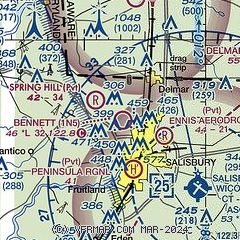
| Sectional chart |
|---|
|
| Airport distance calculator |
|---|
|
|
| Sunrise and sunset |
|---|
|
Times for 11-May-2026
| | Local
(UTC-4) | | Zulu
(UTC) |
|---|
| Morning civil twilight | | 05:26 | | 09:26 |
| Sunrise | | 05:56 | | 09:56 |
| Sunset | | 20:02 | | 00:02 |
| Evening civil twilight | | 20:31 | | 00:31 |
|
| Current date and time |
|---|
| Zulu (UTC) | 11-May-2026 13:41:25 |
|---|
| Local (UTC-4) | 11-May-2026 09:41:25 |
|---|
|
| METAR |
|---|
KSBY
7nm SE | 111254Z 02009G18KT 10SM -RA SCT023 BKN055 OVC095 13/06 A3010 RMK AO2 RAB49 SLP196 P0000 T01330061
|
|
| TAF |
|---|
KSBY
7nm SE | 111120Z 1112/1212 03011G18KT P6SM VCSH BKN020 FM111300 01007KT 6SM -SHRA BR OVC015 FM111800 03008KT P6SM SCT025 OVC060 FM120100 00000KT P6SM FEW250
|
|
| NOTAMs |
|---|
NOTAMs are issued by the DoD/FAA and will open in a separate window not controlled by AirNav.
|
|

