FAA INFORMATION EFFECTIVE 14 MAY 2026
Location
| FAA Identifier: | 23N |
| Lat/Long: | 40-45-27.3460N 073-03-09.6830W
40-45.455767N 073-03.161383W
40.7575961,-73.0526897
(estimated) |
| Elevation: | 39.2 ft. / 11.9 m (surveyed) |
| Variation: | 13W (1985) |
| From city: | 1 mile NW of BAYPORT, NY |
| Time zone: | UTC -4 (UTC -5 during Standard Time) |
| Zip code: | 11705 |
Airport Operations
| Airport use: | Open to the public |
| Activation date: | 10/1945 |
| Control tower: | no |
| ARTCC: | NEW YORK CENTER |
| FSS: | NEW YORK FLIGHT SERVICE STATION |
| NOTAMs facility: | ISP (NOTAM-D service available) |
| Attendance: | 0800-DUSK |
| Pattern altitude: | 639.2 ft. MSL |
| Wind indicator: | yes |
| Segmented circle: | yes |
Airport Communications
| CTAF/UNICOM: | 122.7 |
| WX ASOS at ISP (3 nm NW): | 120.725 (631-471-0131) |
| WX ASOS at HWV (9 nm NE): | 119.625 (631-399-7095) |
| WX ASOS at FRG (16 nm W): | PHONE 631-752-8129 |
| WX ASOS at FOK (20 nm E): | 119.925 (631-288-0588) |
Nearby radio navigation aids
| VOR radial/distance | | VOR name | | Freq | | Var |
|---|
| DPKr112/11.6 | | DEER PARK VOR/DME | | 117.70 | | 12W |
| CCCr241/15.5 | | CALVERTON VOR/DME | | 114.55 | | 13W |
| BDRr184/24.4 | | BRIDGEPORT VOR/DME | | 108.80 | | 12W |
| JFKr089/33.5 | | KENNEDY VOR/DME | | 115.90 | | 12W |
| HTOr267/34.8 | | HAMPTON VORTAC | | 113.60 | | 13W |
| LGAr104/37.1 | | LA GUARDIA VOR/DME | | 113.10 | | 12W |
| MADr219/37.1 | | MADISON VOR/DME | | 110.40 | | 13W |
| CRIr088/39.3 | | CANARSIE VOR/DME | | 112.30 | | 11W |
| CMKr155/39.4 | | CARMEL VOR/DME | | 116.60 | | 12W |
| NDB name | | Hdg/Dist | | Freq | | Var | | ID |
|---|
| LOKKS | | 089/6.5 | | 366 | | 14W | | IS | .. ... |
Airport Services
| Parking: | tiedowns |
| Bottled oxygen: | NONE |
| Bulk oxygen: | NONE |
Runway Information
Runway 18/36
| Dimensions: | 2750 x 150 ft. / 838 x 46 m |
| Surface: | turf, in good condition |
| Runway edge markings: | RWY 36 THLD AND DTHR MKD WITH CONCRETE BLOCKS FLUSH WITH TURF SFC. |
| Operational restrictions: | RWY 18/36: WEST 75 FT WIDTH OPEN MAY-SEPT, EAST 75 FT WIDTH OPEN OCT-APR. |
| RUNWAY 18 | | RUNWAY 36 |
| Latitude: | 40-45.680375N | | 40-45.231162N |
| Longitude: | 073-03.198812W | | 073-03.123960W |
| Elevation: | 38.9 ft. | | 31.4 ft. |
| Traffic pattern: | right | | left |
| Displaced threshold: | no | | 556 ft.
RWY 36 THLD MKD WITH 1 FT WIDE APN AND 2 FT WIDE THRD (WHITE) BOTH MADE WITH CONC BLOCKS FLUSH WITH TURF SFC. |
| Markings: | NSTD, in fair condition | | NSTD, in fair condition |
| Touchdown point: | yes, no lights | | yes, no lights |
| Obstructions: | 51 ft. trees, 355 ft. from runway, 129 ft. right of centerline, 6:1 slope to clear
RWY 36 CLNC SLOPE 10:1 TO DTHR. | | 52 ft. trees, 10 ft. from runway, 40 ft. left of centerline
CTLG OBSTN EXCEEDS A 45 DEG SLP. |
Airport Ownership and Management from official FAA records
| Ownership: | Publicly-owned |
| Owner: | TOWN OF ISLIP
3RD AVE
BAYPORT, NY 11705
Phone 631-467-3300 |
| Manager: | ROBERT SCHNEIDER
100 ARRIVAL AVE, SUITE 100
RONKONKOMA, NY 11779
Phone 631-467-3300 |
Additional Remarks
| - | ALL TFC ENTER 45 DEG LEFT BASE FOR RWY36 AT 600 MSL DUE HEAVY JET TFC RWY 33L AT ISP. ALL TFC ENTER 45 DEG RIGHT. DOWNWIND RWY 18 OVER LAKES AT 600 MSL DUE HEAVY JET TFC LNDG RWY 33L AT ISP. |
| - | ALL DOWNWIND SPACING FOR RWY 18/36 S/B OVER LAKES FOR NOISE ABATEMENT. |
| - | PHONE AT ARPT 631-467-3279. |
| - | NO CLSD TFC PATTERN OR TOUCH AND GO LNDGS. |
| - | ARPT CLSD 30 MIN AFTER SS TIL 30 MIN BEFORE SR. |
| - | PILOTS BE ADVISED: DUE TO PATTERN PROCEDURES, AIRCRAFT IN THE RUN-UP AREA OR STARTING TAKEOFF ROLL ON RY 36, AND AIRCRAFT ON FINAL APPROACH TO RY 36, MAY NOT BE ABLE TO SEE EACH OTHER DUE TO TREES. |
| - | FOR CD CTC NEW YORK APCH AT 516-683-2449. |
Instrument Procedures
There are no published instrument procedures at 23N.
Some nearby airports with instrument procedures:
KISP - Long Island Mac Arthur Airport (3 nm NW)
KHWV - Brookhaven Airport (9 nm NE)
KFRG - Republic Airport (16 nm W)
KFOK - Francis S Gabreski Airport (20 nm E)
KBDR - Bridgeport/Sikorsky Airport (25 nm N)
|
|

Road maps at:
MapQuest
Bing
Google
| Aerial photo |
|---|
WARNING: Photo may not be current or correct
 Photo by Kevin P. Coughlin/FlyingDogPhotos.com
Photo taken 07-May-2011
looking north.
Photo by Kevin P. Coughlin/FlyingDogPhotos.com
Photo taken 07-May-2011
looking north.
Do you have a better or more recent aerial photo of Bayport Aerodrome that you would like to share? If so, please send us your photo.
|
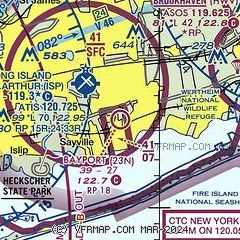
| Sectional chart |
|---|
|
| Airport distance calculator |
|---|
|
|
| Sunrise and sunset |
|---|
|
Times for 30-May-2026
| | Local
(UTC-4) | | Zulu
(UTC) |
|---|
| Morning civil twilight | | 04:52 | | 08:52 |
| Sunrise | | 05:25 | | 09:25 |
| Sunset | | 20:14 | | 00:14 |
| Evening civil twilight | | 20:47 | | 00:47 |
|
| Current date and time |
|---|
| Zulu (UTC) | 31-May-2026 00:16:42 |
|---|
| Local (UTC-4) | 30-May-2026 20:16:42 |
|---|
|
| METAR |
|---|
KISP
3nm NW | 302356Z 04010KT 10SM FEW035 FEW060 FEW250 12/04 A3005 RMK AO2 SLP175 T01170044 10128 20100 51016
|
KHWV
9nm NE | 302356Z AUTO 02005KT 10SM CLR 11/04 A3006 RMK AO2 SLP177 T01060039 10122 20100 51015 PWINO $
|
KFRG
17nm W | 302353Z 04007KT 10SM CLR 12/04 A3005 RMK AO2 SLP177 T01170044 10144 20117 51017
|
|
| TAF |
|---|
KISP
3nm NW | 301946Z 3020/3118 01022G35KT P6SM BKN035 FM302200 02016G26KT P6SM SCT040 FM310100 02007KT P6SM FEW040 FM310600 33007KT P6SM SKC FM311600 27010G19KT P6SM FEW080
|
|
| NOTAMs |
|---|
NOTAMs are issued by the DoD/FAA and will open in a separate window not controlled by AirNav.
|
|

