FAA INFORMATION EFFECTIVE 14 MAY 2026
Location
| FAA Identifier: | 2W6 |
| Lat/Long: | 38-18-56.5510N 076-33-07.7720W
38-18.942517N 076-33.129533W
38.3157086,-76.5521589
(estimated) |
| Elevation: | 141.6 ft. / 43.2 m (surveyed) |
| Variation: | 10W (1995) |
| From city: | 4 miles NE of LEONARDTOWN, MD |
| Time zone: | UTC -4 (UTC -5 during Standard Time) |
| Zip code: | 20636 |
Airport Operations
| Airport use: | Open to the public |
| Activation date: | 12/1969 |
| Control tower: | no |
| ARTCC: | WASHINGTON CENTER |
| FSS: | LEESBURG FLIGHT SERVICE STATION |
| NOTAMs facility: | DCA (NOTAM-D service available) |
| Attendance: | 0800-1700 |
| Wind indicator: | lighted |
| Segmented circle: | yes |
| Lights: | ACTVT REIL RWY 11 & 29; MIRL RWY 11/29 - CTAF. PAPI RWY 11 & 29 OPRS CONSLY. |
| Beacon: | white-green (lighted land airport)
Operates sunset to sunrise. |
Airport Communications
| CTAF/UNICOM: | 123.0 |
| WX AWOS-3: | 119.575 (301-373-6514) |
| PATUXENT APPROACH: | 121.0 |
| POTOMAC APPROACH: | 135.625 ;WHEN NHK APCH CLSD |
| PATUXENT DEPARTURE: | 121.0 |
| POTOMAC DEPARTURE: | 135.625 ;WHEN NHK APCH CLSD |
- APCH/DEP SVC PRVDD BY POTOMAC TRACON ON 135.625/269.625 WHEN PATUXENT APCH CTL CLSD.
Nearby radio navigation aids
| VOR radial/distance | | VOR name | | Freq | | Var |
|---|
| ADWr163/33.0 | | ANDREWS VORTAC | | 113.10 | | 10W |
| BRVr101/37.7 | | BROOKE VORTAC | | 114.50 | | 09W |
| DCAr154/39.8 | | WASHINGTON VOR/DME | | 111.00 | | 09W |
| NDB name | | Hdg/Dist | | Freq | | Var | | ID |
|---|
| OXONN | | 151/35.0 | | 332 | | 11W | | VQK | ...- --.- -.- |
Airport Services
| Fuel available: | 100LL JET-A
100LL:SELF SERVE 100LL AVBL WITH CREDIT CARD. |
| Parking: | tiedowns |
| Airframe service: | MAJOR |
| Powerplant service: | MAJOR |
| Bottled oxygen: | NONE |
| Bulk oxygen: | NONE |
Runway Information
Runway 11/29
| Dimensions: | 5350 x 75 ft. / 1631 x 23 m |
| Surface: | asphalt, in fair condition
UNFILLED CRACKS, VEGETATIVE GROWTH, OXIDATION, RAVELLING. |
| Weight bearing capacity: | |
| Runway edge lights: | medium intensity |
| Runway edge markings: | FADED. |
| RUNWAY 11 | | RUNWAY 29 |
| Latitude: | 38-19.036548N | | 38-18.848440N |
| Longitude: | 076-33.676063W | | 076-32.583033W |
| Elevation: | 140.6 ft. | | 124.9 ft. |
| Traffic pattern: | left | | left |
| Runway heading: | 112 magnetic, 102 true | | 292 magnetic, 282 true |
| Markings: | nonprecision, in good condition | | nonprecision, in fair condition |
| Visual slope indicator: | 4-light PAPI on left (3.00 degrees glide path) | | 4-light PAPI on left (3.00 degrees glide path) |
| Runway end identifier lights: | yes | | yes |
| Touchdown point: | yes, no lights | | yes, no lights |
Airport Ownership and Management from official FAA records
| Ownership: | Publicly-owned |
| Owner: | THE COMMISSIONERS OF ST. MARYS CO.
P.O. BOX 653, 41770 BALDRIDGE STREET
LEONARDTOWN, MD 20650
Phone 301-475-4200
EXT 1321 |
| Manager: | ALLISON SWINT
P.O. BOX 508, 44825 ST ANDREWS CHURCH ROAD
CALIFORNIA, MD 20619
Phone 301-475-4200
EXT 3511 |
Additional Remarks
| - | DEER ON & INVOF RWY 11/29 SS-SR. |
| - | GLDR, UAS, AND ULTRALIGHT ACTVT ON & INVOF ARPT. |
| - | RWY 29 15 FT DEPRESSION (DOWNSLOPE) 300 FT FM THR 150 FT R-125 L. |
| - | FOR CD CTC PATUXENT APCH AT 301-342-3740, WHEN PATUXENT APCH IS CLSD CTC POTOMAC APCH AT 866-640-4124. |
| - | WHEN R-4007 IN EFFECT, ACFT OPRNG VFR AT ARPT MUST RMN WITHIN 1.5 NM OF ARPT, AT OR BLW 1500 FT MSL, AND ABV 700 FT AGL. |
| - | ALL VFR FLT OPS CONDUCTED WI R-4007 SHALL BE AT OR BLW 1000 FT MSL. IFR AND VFR APCHS WI R-4007 WILL BE COORDD WITH PATUXENT APCH ON 121.0 OR BY PHONE 301-342-3740. |
| - | MIL ACFT ON INSTR APCH TO PAX RIVER NAS MAY OVERFLY ARPT AT 1600 FT MSL & NOT MNT CTAF. WHEN PAX RWY 14 IN USE, 2W6 ACFT CROSS APCH PATH AT OR BLW 1000 FT OR ABOVE 3000 FT. MIL HELO OPS INVOF ARPT. |
| A58-11 | 30 FT TREES AT THLD, 160 FT L. |
Instrument Procedures
NOTE: All procedures below are presented as PDF files. If you need a reader for these files, you should download the free Adobe Reader.NOT FOR NAVIGATION. Please procure official charts for flight.
FAA instrument procedures published for use from 14 May 2026 at 0901Z to 11 June 2026 at 0900Z.
IAPs - Instrument Approach Procedures |
|---|
| RNAV (GPS) RWY 11 | |
download (256KB) |
| RNAV (GPS) RWY 29 | |
download (271KB) |
| NOTE: Special Take-Off Minimums/Departure Procedures apply | |
download (367KB) |
Other nearby airports with instrument procedures:
KNHK - Patuxent River Naval Air Station (Trapnell Field) Airport (7 nm E)
KCGE - Cambridge-Dorchester Regional Airport (28 nm NE)
2W5 - Maryland Airport (30 nm NW)
KXSA - Tappahannock/Essex County Airport (32 nm SW)
KVKX - Potomac Airfield (32 nm NW)
|
|

Road maps at:
MapQuest
Bing
Google
| Aerial photo |
|---|
WARNING: Photo may not be current or correct
 Photo by Sharon M.
Photo taken 08-Nov-2020
looking northeast.
Photo by Sharon M.
Photo taken 08-Nov-2020
looking northeast.
Do you have a better or more recent aerial photo of St Mary's County Regional Airport that you would like to share? If so, please send us your photo.
|
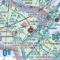
| Sectional chart |
|---|
|
| Airport distance calculator |
|---|
|
|
| Sunrise and sunset |
|---|
|
Times for 30-May-2026
| | Local
(UTC-4) | | Zulu
(UTC) |
|---|
| Morning civil twilight | | 05:15 | | 09:15 |
| Sunrise | | 05:46 | | 09:46 |
| Sunset | | 20:21 | | 00:21 |
| Evening civil twilight | | 20:52 | | 00:52 |
|
| Current date and time |
|---|
| Zulu (UTC) | 31-May-2026 00:14:07 |
|---|
| Local (UTC-4) | 30-May-2026 20:14:07 |
|---|
|
| METAR |
|---|
| K2W6 | 302335Z AUTO VRB04KT 10SM CLR 19/07 A3005 RMK AO2 T01890073 $
|
KNHK
8nm E | 302352Z AUTO 01015KT 10SM CLR 19/07 A3004 RMK AO2 SLP173 T01940072 10211 20194 53022 $
|
KNUI
12nm SE | 302353Z AUTO 05005KT 10SM CLR 19/07 A3004 RMK AO2 SLP171 T01890072 10206 20189 53022 $
|
|
| TAF |
|---|
KNHK
8nm E | 302300Z 3023/3123 VRB06KT 9999 VCSH FEW020 SCT050 QNH2980INS TEMPO 3109/3115 8000 BR SCT020 BKN050 FM311600 VRB06KT 9999 FEW070 SCT120 QNH2978INS AUTOMATED SENSOR METWATCH 3107 TIL 3111 TX22/3120Z TN13/3109Z FN00172
|
|
| NOTAMs |
|---|
NOTAMs are issued by the DoD/FAA and will open in a separate window not controlled by AirNav.
|
|


