FAA INFORMATION EFFECTIVE 02 OCTOBER 2025
Location
| FAA Identifier: | 2G1 |
| Lat/Long: | 41-40-01.3566N 081-11-49.8601W
41-40.022610N 081-11.831002W
41.6670435,-81.1971834
(estimated) |
| Elevation: | 998.6 ft. / 304.4 m (surveyed) |
| Variation: | 07W (1985) |
| From city: | 3 miles SE of PAINESVILLE, OH |
| Time zone: | UTC -4 (UTC -5 during Standard Time) |
| Zip code: | 44077 |
Airport Operations
| Airport use: | Open to the public |
| Activation date: | 11/1954 |
| Control tower: | no |
| ARTCC: | CLEVELAND CENTER |
| FSS: | CLEVELAND FLIGHT SERVICE STATION |
| NOTAMs facility: | CLE (NOTAM-D service available) |
| Attendance: | IREG |
| Wind indicator: | yes |
| Segmented circle: | no |
| Lights: | FOR LOCAL TFC ONLY; FOR RY LGTS CALL 440-352-3228. |
Airport Communications
| CTAF/UNICOM: | 122.8 |
| CLEVELAND APPROACH: | 125.35 |
| CLEVELAND DEPARTURE: | 125.35 |
| WX AWOS-3PT at LNN (9 nm W): | 119.225 (440-942-0809) |
| WX AWOS-3PT at CGF (14 nm SW): | PHONE 216-289-4113 |
Nearby radio navigation aids
| VOR radial/distance | | VOR name | | Freq | | Var |
|---|
| CXRr355/9.1 | | CHARDON VOR/DME | | 112.70 | | 05W |
| ACOr004/33.5 | | AKRON VOR/DME | | 114.40 | | 04W |
Airport Services
| Parking: | hangars and tiedowns |
| Bottled oxygen: | NONE |
| Bulk oxygen: | NONE |
Runway Information
Runway 3/21
| Dimensions: | 2181 x 38 ft. / 665 x 12 m |
| Surface: | asphalt, in fair condition
EXTSV PAVEMENT CRACKING WI VEGETATION GROWING THRU. |
| Weight bearing capacity: | |
| Runway edge lights: | low intensity
NSTD LGTS; NON-FAA APVD FIXTURES ON E SIDE OF RWY ONLY. |
| Runway edge markings: | FADED. |
| RUNWAY 3 | | RUNWAY 21 |
| Latitude: | 41-39.855733N | | 41-40.189485N |
| Longitude: | 081-11.919445W | | 081-11.742535W |
| Elevation: | 994.1 ft. | | 967.6 ft. |
| Traffic pattern: | left | | left |
| Runway heading: | 029 magnetic, 022 true | | 209 magnetic, 202 true |
| Markings: | basic, in poor condition | | basic, in poor condition |
| Runway end identifier lights: | no | | no |
| Touchdown point: | yes, no lights | | yes, no lights |
| Obstructions: | 73 ft. trees, 258 ft. from runway, 64 ft. right of centerline, 1:1 slope to clear
40 FT TREES 50-199 FT DSTC 125 FT L & R. | | 75 ft. trees, 201 ft. from runway, 121 ft. right of centerline, 1:1 slope to clear
20-50 FT TREES 0 FT DSTC. |
Airport Ownership and Management from official FAA records
| Ownership: | Privately-owned |
| Owner: | CONCORD AIRPARK, INC
12361 CONCORD-HAMBDEN RD
PAINESVILLE, OH 44077-9253
Phone 440-352-3228 |
| Manager: | CONNIE LUHTA
12253 CONCORD-HAMBDEN RD
PAINESVILLE, OH 44077-9566
Phone 440-227-1368 |
Additional Remarks
| - | BIRDS ON & INVOF ARPT. |
| - | FOR CD CTC CLEVELAND APCH AT 216-352-2323. |
| - | NGT OPS NA. |
Instrument Procedures
NOTE: All procedures below are presented as PDF files. If you need a reader for these files, you should download the free Adobe Reader.NOT FOR NAVIGATION. Please procure official charts for flight.
FAA instrument procedures published for use from 02 October 2025 at 0901Z to 30 October 2025 at 0900z.
IAPs - Instrument Approach Procedures |
|---|
| RNAV (GPS)-A | |
download (145KB) |
| RNAV (GPS)-A | |
download (145KB) |
| NOTE: Special Take-Off Minimums/Departure Procedures apply | |
download (482KB) |
Other nearby airports with instrument procedures:
KLNN - Lake County Executive Airport (9 nm W)
7G8 - Geauga County Airport (14 nm SE)
KCGF - Cuyahoga County Airport (14 nm SW)
KHZY - Northeast Ohio Regional Airport (23 nm E)
KBKL - Burke Lakefront Airport (24 nm W)
|
|

Road maps at:
MapQuest
Bing
Google
| Aerial photo |
|---|
WARNING: Photo may not be current or correct

Do you have a better or more recent aerial photo of Concord Airpark that you would like to share? If so, please send us your photo.
|
| Sectional chart |
|---|
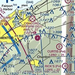
|
| Airport distance calculator |
|---|
|
|
| Sunrise and sunset |
|---|
|
Times for 17-Oct-2025
| | Local
(UTC-4) | | Zulu
(UTC) |
|---|
| Morning civil twilight | | 07:12 | | 11:12 |
| Sunrise | | 07:40 | | 11:40 |
| Sunset | | 18:40 | | 22:40 |
| Evening civil twilight | | 19:08 | | 23:08 |
|
| Current date and time |
|---|
| Zulu (UTC) | 17-Oct-2025 13:12:39 |
|---|
| Local (UTC-4) | 17-Oct-2025 09:12:39 |
|---|
|
| METAR |
|---|
KLNN
8nm W | 171255Z AUTO 15004KT 10SM CLR 09/00 A3013 RMK AO1 T00901002
|
KCGF
14nm SW | 171245Z 18005KT 10SM CLR 08/02 A3013
|
|
| NOTAMs |
|---|
NOTAMs are issued by the DoD/FAA and will open in a separate window not controlled by AirNav.
|
|


