FAA INFORMATION EFFECTIVE 11 JUNE 2026
Location
| FAA Identifier: | 3A2 |
| Lat/Long: | 36-24-32.0300N 083-33-25.8690W
36-24.533833N 083-33.431150W
36.4088972,-83.5571858
(estimated) |
| Elevation: | 1178.8 ft. / 359.3 m (surveyed) |
| Variation: | 05W (2005) |
| From city: | 3 miles SE of TAZEWELL, TN |
| Time zone: | UTC -4 (UTC -5 during Standard Time) |
| Zip code: | 37879 |
Airport Operations
| Airport use: | Open to the public |
| Control tower: | no |
| ARTCC: | ATLANTA CENTER |
| FSS: | NASHVILLE FLIGHT SERVICE STATION |
| NOTAMs facility: | BNA (NOTAM-D service available) |
| Attendance: | 0800-1600
AFT HR - AMGR. |
| Wind indicator: | lighted |
| Segmented circle: | yes |
| Lights: | ACTVT PAPI RWY 07 & 25 - CTAF. |
| Beacon: | white-green (lighted land airport)
Operates sunset to sunrise. |
Airport Communications
| CTAF: | 122.9 |
| WX AWOS-3 at 1A6 (15 nm NW): | 119.425 (606-248-3095) |
| WX AWOS-3 at MOR (16 nm SE): | 126.725 (423-587-5886) |
- APCH/DEP SVC PRVDD BY ATLANTA ARTCC ON FREQS 133.6/254.3 (HINCH MOUNTAIN RCAG).
Nearby radio navigation aids
| VOR radial/distance | | VOR name | | Freq | | Var |
|---|
| VXVr031/34.4 | | VOLUNTEER VORTAC | | 116.40 | | 03W |
Airport Services
| Fuel available: | 100LL |
| Parking: | tiedowns |
| Airframe service: | MAJOR |
| Powerplant service: | MAJOR |
Runway Information
Runway 7/25
| Dimensions: | 5208 x 75 ft. / 1587 x 23 m |
| Surface: | asphalt, in good condition |
| Weight bearing capacity: | | PCN 9 /F/D/X/T | | Single wheel: | 24.0 |
|
| Runway edge lights: | medium intensity |
| RUNWAY 7 | | RUNWAY 25 |
| Latitude: | 36-24.350033N | | 36-24.717598N |
| Longitude: | 083-33.910915W | | 083-32.951352W |
| Elevation: | 1176.6 ft. | | 1172.2 ft. |
| Traffic pattern: | left | | left |
| Runway heading: | 070 magnetic, 065 true | | 250 magnetic, 245 true |
| Markings: | basic, in good condition | | basic, in good condition |
| Visual slope indicator: | 2-light PAPI on left (3.50 degrees glide path) | | 2-light PAPI on left |
| Runway end identifier lights: | yes | | yes |
| Touchdown point: | yes, no lights | | yes, no lights |
| Obstructions: | 29 ft. trees, 794 ft. from runway, 59 ft. left of centerline, 20:1 slope to clear | | 148 ft. tree, 4300 ft. from runway, 881 ft. left of centerline, 27:1 slope to clear |
Airport Ownership and Management from official FAA records
| Ownership: | Publicly-owned |
| Owner: | CITY OF NEW TAZEWELL
PO BOX 609
NEW TAZEWELL, TN 37824
Phone (423) 626-5242 |
| Manager: | JOSH OVERTONE
380 AIRPORT LANE
TAZEWELL, TN 37879
Phone 865-567-4348 |
Additional Remarks
| - | DEER ON & INVOF ARPT. |
| - | FOR CD CTC ATLANTA ARTCC AT 770-210-7692. |
Instrument Procedures
NOTE: All procedures below are presented as PDF files. If you need a reader for these files, you should download the free Adobe Reader.NOT FOR NAVIGATION. Please procure official charts for flight.
FAA instrument procedures published for use from 11 June 2026 at 0901Z to 09 July 2026 at 0900z.
IAPs - Instrument Approach Procedures |
|---|
| RNAV (GPS) RWY 07 | |
download (186KB) |
| NOTE: Special Take-Off Minimums/Departure Procedures apply | |
download |
Other nearby airports with instrument procedures:
1A6 - Middlesboro/Bell County Airport (15 nm NW)
KMOR - Moore-Murrell Airport (16 nm SE)
0VG - Lee County Airport (22 nm NE)
I35 - Tucker-Guthrie Memorial Airport (29 nm N)
KJAU - Colonel Tommy C Stiner Airfield (30 nm W)
|
|

Road maps at:
MapQuest
Bing
Google
| Aerial photo |
|---|
WARNING: Photo may not be current or correct
 Photo by Morgan Michel
Do you have a better or more recent aerial photo of New Tazewell Municipal Airport that you would like to share? If so, please send us your photo.
|
| Sectional chart |
|---|
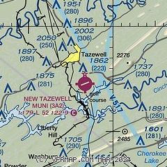
|
| Airport distance calculator |
|---|
|
|
| Sunrise and sunset |
|---|
|
Times for 12-Jun-2026
| | Local
(UTC-4) | | Zulu
(UTC) |
|---|
| Morning civil twilight | | 05:46 | | 09:46 |
| Sunrise | | 06:17 | | 10:17 |
| Sunset | | 20:51 | | 00:51 |
| Evening civil twilight | | 21:22 | | 01:22 |
|
| Current date and time |
|---|
| Zulu (UTC) | 12-Jun-2026 21:34:31 |
|---|
| Local (UTC-4) | 12-Jun-2026 17:34:31 |
|---|
|
| METAR |
|---|
K1A6
15nm NW | 122115Z AUTO 28005KT 10SM CLR 32/19 A2997 RMK AO2 T03210189
|
KMOR
16nm SE | 122055Z AUTO 29012G17KT 9SM 30/23 A2999 RMK A01
|
K0VG
22nm NE | 122115Z AUTO 00000KT 10SM CLR 28/22 A2998 RMK AO2
|
KI35
29nm N | 122115Z AUTO 28008KT 7SM SCT046 SCT060 31/21 A2998 RMK AO2 T03050208
|
KJAU
30nm W | 122110Z AUTO 25004KT 10SM CLR 31/18 A2995 RMK A01
|
|
| NOTAMs |
|---|
NOTAMs are issued by the DoD/FAA and will open in a separate window not controlled by AirNav.
|
|

