FAA INFORMATION EFFECTIVE 09 JULY 2026
Location
| FAA Identifier: | 3B4 |
| Lat/Long: | 43-08-35.2835N 070-46-24.3700W
43-08.588058N 070-46.406167W
43.1431343,-70.7734361
(estimated) |
| Elevation: | 124.8 ft. / 38 m (estimated) |
| Variation: | 16W (1995) |
| From city: | 2 miles SE of ELIOT, ME |
| Time zone: | UTC -4 (UTC -5 during Standard Time) |
| Zip code: | 03903 |
Airport Operations
| Airport use: | CLOSED INDEFINITELY |
| Activation date: | 08/1966 |
| Control tower: | no |
| ARTCC: | BOSTON CENTER |
| FSS: | BANGOR FLIGHT SERVICE STATION |
| NOTAMs facility: | BGR (NOTAM-D service available) |
| Attendance: | UNATNDD |
| Wind indicator: | yes |
| Segmented circle: | no |
Airport Communications
| CTAF: | 122.9 |
| BOSTON APPROACH: | 125.05 |
| BOSTON DEPARTURE: | 125.05 |
| IC: | 125.05 |
| WX ASOS at DAW (11 nm NW): | 135.275 (603-332-7814) |
| WX AWOS-3PT at SFM (15 nm N): | 120.025 (207-324-1958) |
Nearby radio navigation aids
| VOR radial/distance | | VOR name | | Freq | | Var |
|---|
| ENEr219/18.3 | | KENNEBUNK VOR/DME | | 117.10 | | 17W |
| CONr112/35.4 | | CONCORD VOR/DME | | 112.90 | | 15W |
| NDB name | | Hdg/Dist | | Freq | | Var | | ID |
|---|
| ROLLINS | | 169/5.2 | | 260 | | 16W | | ESG | . ... --. |
Airport Services
| Parking: | tiedowns |
| Airframe service: | NONE |
| Powerplant service: | NONE |
| Bottled oxygen: | NONE |
| Bulk oxygen: | NONE |
Runway Information
Runway 12/30
| Dimensions: | 2701 x 50 ft. / 823 x 15 m |
| Surface: | asphalt, in excellent condition |
| Weight bearing capacity: | |
| RUNWAY 12 | | RUNWAY 30 |
| Latitude: | 43-08.664617N | | 43-08.511500N |
| Longitude: | 070-46.691000W | | 070-46.121333W |
| Elevation: | 123.6 ft. | | 105.7 ft. |
| Traffic pattern: | left | | left |
| Runway heading: | 126 magnetic, 110 true | | 306 magnetic, 290 true |
| Displaced threshold: | no | | 86 ft. |
| Markings: | nonprecision, in good condition | | nonprecision, in good condition |
| Touchdown point: | yes, no lights | | yes, no lights |
| Obstructions: | 25 ft. trees, 201 ft. from runway, 60 ft. left of centerline
20-25 FT TREES AND BRUSH 0-200 FT FM THR, 115-125 FT L OF CNTRLN; 5-25 FT TREES 5-150 FT FM THR, 15-150 FT R OF CNTRLN AND 15-250 FT L OF CNTRLN. | | 30 ft. trees, 360 ft. from runway, 130 ft. right of centerline, 5:1 slope to clear
20 FT TREES 90-135 FT FM THR, 90 FT R OF CNTRLN; 23 FT HOUSE 68 FT FM THR, 118 FT L OF CNTRLN; 35 FT TREES 90 FT FM THR, 100 FT L OF CNTRLN. |
Airport Ownership and Management from official FAA records
| Ownership: | Privately-owned |
| Owner: | SHAMROCK AVIATION
380 LAFAYETTE RD, UNIT 11-209
SEABROOK, NH 03874
Phone 207-200-5019 |
| Manager: | THOMAS SHAUGHNESSY
380 LAFAYETTE RD, SUITE 11-209
SEABROOK, NH 03874
Phone 949-378-8405 |
Additional Remarks
| - | BIRDS & DEER ON & INVOF ARPT. |
| - | FOR CD CTC BOSTON APCH AT 603-594-5551. |
| - | (ARPT STATUS) ARPT CLSD INDEFLY. |
Instrument Procedures
There are no published instrument procedures at 3B4.
Some nearby airports with instrument procedures:
KPSM - Portsmouth International Airport at Pease (4 nm SW)
KDAW - Skyhaven Airport (11 nm NW)
KSFM - Sanford Seacoast Regional Airport (15 nm N)
B19 - Biddeford Municipal Airport (23 nm NE)
KLWM - Lawrence Municipal Airport (30 nm SW)
|
|

Road maps at:
MapQuest
Bing
Google
| Aerial photo |
|---|
WARNING: Photo may not be current or correct
 Photo by Mya Dundzila
Photo taken 12-Nov-2018
looking west-northwest.
Photo by Mya Dundzila
Photo taken 12-Nov-2018
looking west-northwest.
Do you have a better or more recent aerial photo of Seacoast Airfield that you would like to share? If so, please send us your photo.
|
| Sectional chart |
|---|
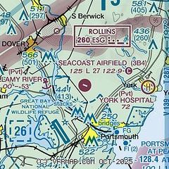
|
| Airport distance calculator |
|---|
|
|
| Sunrise and sunset |
|---|
|
Times for 28-Jul-2026
| | Local
(UTC-4) | | Zulu
(UTC) |
|---|
| Morning civil twilight | | 04:58 | | 08:58 |
| Sunrise | | 05:30 | | 09:30 |
| Sunset | | 20:09 | | 00:09 |
| Evening civil twilight | | 20:42 | | 00:42 |
|
| Current date and time |
|---|
| Zulu (UTC) | 28-Jul-2026 15:06:10 |
|---|
| Local (UTC-4) | 28-Jul-2026 11:06:10 |
|---|
|
| METAR |
|---|
KPSM
5nm S | 281429Z 16003KT 10SM SCT010 23/19 A2975 RMK AO2A SLP076
|
KDAW
10nm NW | 281451Z AUTO 14004KT 10SM CLR 25/19 A2976 RMK AO2 SLP074 T02500194 57008 $
|
KSFM
15nm N | 281456Z AUTO VRB05KT 10SM BKN014 25/19 A2977 RMK AO2 SLP083 T02500194 58004
|
|
| TAF |
|---|
KPSM
5nm S | 281138Z 2812/2912 00000KT P6SM VCFG OVC004 FM281500 14008KT P6SM SCT006 SCT030 OVC100 FM281800 14009G17KT P6SM VCSH BKN040 FM290000 15005KT P6SM BKN040 FM290400 14004KT P6SM BKN013
|
|
| NOTAMs |
|---|
NOTAMs are issued by the DoD/FAA and will open in a separate window not controlled by AirNav.
|
|

