FAA INFORMATION EFFECTIVE 16 APRIL 2026
Location
| FAA Identifier: | 3J0 |
| Lat/Long: | 32-51-59.4400N 081-04-51.4930W
32-51.990667N 081-04.858217W
32.8665111,-81.0809703
(estimated) |
| Elevation: | 112.1 ft. / 34.2 m (surveyed) |
| Variation: | 04W (1985) |
| From city: | 1 mile E of HAMPTON, SC |
| Time zone: | UTC -4 (UTC -5 during Standard Time) |
| Zip code: | 29944 |
Airport Operations
| Airport use: | Open to the public |
| Activation date: | 03/1947 |
| Control tower: | no |
| ARTCC: | JACKSONVILLE CENTER |
| FSS: | ANDERSON FLIGHT SERVICE STATION |
| NOTAMs facility: | AND (NOTAM-D service available) |
| Attendance: | MON-FRI 0800-1700, ALL SAT 0830-1700, ALL SUN 1200-1700 |
| Wind indicator: | lighted |
| Segmented circle: | no |
Airport Communications
| CTAF: | 122.9 |
| WX AWOS-3PT at AQX (12 nm NW): | 118.950 (803-584-3696) |
Nearby radio navigation aids
| VOR radial/distance | | VOR name | | Freq | | Var |
|---|
| ALDr130/(13.8) | | ALLENDALE VOR | | 116.70 | | 01W |
Airport Services
| Fuel available: | 100LL JET-A
100LL:100LL & JET A FUEL ABL 24 HRS SELF SVC WITH CREDIT CARD. |
| Parking: | tiedowns |
| Airframe service: | NONE |
| Powerplant service: | NONE |
| Bottled oxygen: | NONE |
| Bulk oxygen: | NONE |
Runway Information
Runway 11/29
| Dimensions: | 3601 x 60 ft. / 1098 x 18 m |
| Surface: | asphalt, in fair condition |
| Weight bearing capacity: | |
| RUNWAY 11 | | RUNWAY 29 |
| Latitude: | 32-52.092810N | | 32-51.888525N |
| Longitude: | 081-05.188537W | | 081-04.527912W |
| Elevation: | 106.5 ft. | | 111.4 ft. |
| Traffic pattern: | left | | right |
| Runway heading: | 114 magnetic, 110 true | | 294 magnetic, 290 true |
| Markings: | basic, in good condition | | basic, in good condition |
| Touchdown point: | yes, no lights | | yes, no lights |
| Obstructions: | 77 ft. tree, 1057 ft. from runway, 158 ft. left of centerline, 11:1 slope to clear | | 100 ft. tree, 1184 ft. from runway, 96 ft. right of centerline, 9:1 slope to clear
OFF RWY 29, A YELLOW PROPERTY POST 100 FT FM THLD AND 35 FT LEFT OF CNTRLN. ALSO A 20 FT POWER POLE 145 FT FM THLD AND 75 FT LEFT OF CNTRLN. ALSO A 23 FT TREE 131 FT FM THLD AND 66 FT LEFT OF CNTRLN. |
Airport Ownership and Management from official FAA records
| Ownership: | Publicly-owned |
| Owner: | HAMPTON COUNTY
201 JACKSON AVENUE WEST
HAMPTON, SC 29924
Phone 803-914-2086 |
| Manager: | CHRISTOPHER S. INGLESE
201 JACKSON AVENUE W
HAMPTON, SC 29924
Phone 803-914-2086 |
Additional Remarks
| - | MKD WATER TANK APRXLY 680 FT FROM RWY 29. |
| - | FOR CD CTC JACKSONVILLE ARTCC AT 904-845-1592. |
| - | ARPT PHONE NR 803-914-2086. |
| - | WX ADZY AVBL: FOUR MIC CLICKS ON CTAF 122.9. ADZY ONLY, NOT FOR IFR USE. |
Instrument Procedures
There are no published instrument procedures at 3J0.
Some nearby airports with instrument procedures:
KAQX - Allendale County Airport (12 nm NW)
KRBW - Lowcountry Regional Airport (22 nm E)
99N - Bamberg County Airport (26 nm N)
KBNL - Barnwell Regional Airport (28 nm NW)
KJYL - Plantation Airpark (29 nm SW)
|
|

Road maps at:
MapQuest
Bing
Google
| Aerial photo |
|---|

|
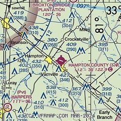
| Sectional chart |
|---|
|
| Airport distance calculator |
|---|
|
|
| Sunrise and sunset |
|---|
|
Times for 24-Apr-2026
| | Local
(UTC-4) | | Zulu
(UTC) |
|---|
| Morning civil twilight | | 06:19 | | 10:19 |
| Sunrise | | 06:45 | | 10:45 |
| Sunset | | 20:00 | | 24:00 |
| Evening civil twilight | | 20:26 | | 00:26 |
|
| Current date and time |
|---|
| Zulu (UTC) | 24-Apr-2026 05:55:23 |
|---|
| Local (UTC-4) | 24-Apr-2026 01:55:23 |
|---|
|
| METAR |
|---|
KAQX
12nm NW | 240435Z AUTO 00000KT 8SM CLR 18/09 A2999 RMK AO2
|
KRBW
22nm E | 240435Z AUTO 00000KT 10SM CLR 14/10 A3001 RMK AO2
|
|
| TAF |
|---|
KNBC
30nm SE | 240200Z 2403/2503 19006KT 9999 SKC QNH2998INS BECMG 2406/2408 22006KT QNH2993INS BECMG 2416/2418 SCT040 SCT080 QNH2989INS TX28/2418Z TN18/2409Z
|
|
| NOTAMs |
|---|
NOTAMs are issued by the DoD/FAA and will open in a separate window not controlled by AirNav.
|
|

