FAA INFORMATION EFFECTIVE 18 APRIL 2024
Location
| FAA Identifier: | 3RC |
| Lat/Long: | 44-28-25.3066N 084-33-49.2270W
44-28.421777N 084-33.820450W
44.4736963,-84.5636742
(estimated) |
| Elevation: | 1157 ft. / 353 m (estimated) |
| Variation: | 05W (1985) |
| From city: | 2 miles SE of ROSCOMMON, MI |
| Time zone: | UTC -4 (UTC -5 during Standard Time) |
| Zip code: | 48653 |
Airport Operations
| Airport use: | Open to the public |
| Activation date: | 12/1942 |
| Control tower: | no |
| ARTCC: | MINNEAPOLIS CENTER |
| FSS: | LANSING FLIGHT SERVICE STATION |
| NOTAMs facility: | LAN (NOTAM-D service available) |
| Attendance: | UNATNDD |
| Wind indicator: | lighted |
| Segmented circle: | no |
| Lights: | ACTVT LIRL RWY 10/28 - CTAF. |
Airport Communications
| CTAF: | 122.9 |
| WX ASOS at HTL (8 nm SW): | 118.05 (989-366-4825) |
| WX ASOS at GOV (14 nm NW): | PHONE 989-348-3127 |
Nearby radio navigation aids
| VOR radial/distance | | VOR name | | Freq | | Var |
|---|
| CGGr157/(14.3) | | GRAYLING VOR | | 109.80 | | 06W |
| GLRr175/32.9 | | GAYLORD VOR/DME | | 109.20 | | 06W |
| NDB name | | Hdg/Dist | | Freq | | Var | | ID |
|---|
| GRAYLING | | 152/20.1 | | 359 | | 06W | | GYG | --. -.-- --. |
Airport Services
Runway Information
Runway 10/28
| Dimensions: | 3552 x 75 ft. / 1083 x 23 m |
| Surface: | asphalt, in excellent condition |
| Runway edge lights: | low intensity |
| RUNWAY 10 | | RUNWAY 28 |
| Latitude: | 44-28.395000N | | 44-28.410000N |
| Longitude: | 084-34.271667W | | 084-33.455500W |
| Elevation: | 1152.0 ft. | | 1150.0 ft. |
| Traffic pattern: | left | | left |
| Runway heading: | 094 magnetic, 089 true | | 274 magnetic, 269 true |
| Displaced threshold: | 150 ft. | | no |
| Markings: | basic, in good condition | | basic, in good condition |
| Runway end identifier lights: | no | | no |
| Touchdown point: | yes, no lights | | yes, no lights |
| Obstructions: | 30 ft. trees, 245 ft. from runway, 115 ft. left of centerline, 1:1 slope to clear
15 FT ROAD, 145 FT DIST; 25 FT TREES, 178 FT DIST; 4 FT FENCE, 85 FT DIST. | | none |
Runway 1/19
| Dimensions: | 2500 x 100 ft. / 762 x 30 m |
| Surface: | turf, in poor condition
SFC ROUGH WITH PATCHES OF GRVL. |
| Runway edge markings: | 3 FT YELLOW CONES. |
| Operational restrictions: | CLSD NOV-APR & WHEN SNOW COVD. |
| RUNWAY 1 | | RUNWAY 19 |
| Latitude: | 44-28.243333N | | 44-28.655000N |
| Longitude: | 084-33.760000W | | 084-33.758333W |
| Elevation: | 1157.0 ft. | | 1151.0 ft. |
| Traffic pattern: | left | | left |
| Runway heading: | 005 magnetic, 000 true | | 185 magnetic, 180 true |
| Displaced threshold: | 770 ft. | | 100 ft. |
| Runway end identifier lights: | no | | no |
| Touchdown point: | yes, no lights | | yes, no lights |
| Obstructions: | 61 ft. trees, 469 ft. from runway, 125 ft. left and right of centerline, 7:1 slope to clear
APCH RATIO 8:1 TO DTHR OVR +10 FT TREE, 86 FT DIST, 80 FT L. | | 56 ft. trees, 1029 ft. from runway, 30 ft. right of centerline, 18:1 slope to clear
APCH RATIO 20:1 TO DTHR. |
Airport Ownership and Management from official FAA records
| Ownership: | Publicly-owned |
| Owner: | MI DEPT OF NATURAL RESOURCES
8717 N ROSCOMMON RD
ROSCOMMON, MI 48653-9207
Phone 989-275-5151
EXTN 2722053. |
| Manager: | KEVIN JACOBS
8717 N ROSCOMMON RD
ROSCOMMON, MI 48653-9207
Phone 989-275-1150
EXTN 2051 FOR OFC. |
Airport Operational Statistics
| Aircraft based on the field: | | 4 | | Single engine airplanes: | | 3 | | Multi engine airplanes: | | 1 |
| |  | |
| Aircraft operations: avg 42/month * | | 80% | local general aviation | | 20% | transient general aviation | | * for 12-month period ending 31 December 2022 | |
Additional Remarks
| - | LRG BIRDS & LRG MAMMALS ON & INVOF ARPT. |
| - | FOR CD CTC MINNEAPOLIS ARTCC AT 651-463-5588. |
Instrument Procedures
There are no published instrument procedures at 3RC.
Some nearby airports with instrument procedures:
KHTL - Roscommon County/Blodgett Memorial Airport (8 nm SW)
KGOV - Grayling Army Airfield (14 nm NW)
Y31 - West Branch Community Airport (21 nm SE)
KGDW - Gladwin Zettel Memorial Airport (30 nm S)
KGLR - Gaylord Regional Airport (33 nm N)
|
|

Road maps at:
MapQuest
Bing
Google
| Aerial photo |
|---|

|
| Sectional chart |
|---|
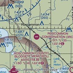
|
| Airport distance calculator |
|---|
|
|
| Sunrise and sunset |
|---|
|
Times for 24-Apr-2024
| | Local
(UTC-4) | | Zulu
(UTC) |
|---|
| Morning civil twilight | | 06:07 | | 10:07 |
| Sunrise | | 06:39 | | 10:39 |
| Sunset | | 20:34 | | 00:34 |
| Evening civil twilight | | 21:05 | | 01:05 |
|
| Current date and time |
|---|
| Zulu (UTC) | 24-Apr-2024 23:23:52 |
|---|
| Local (UTC-4) | 24-Apr-2024 19:23:52 |
|---|
|
| METAR |
|---|
KHTL
9nm SW | 242253Z AUTO 24005KT 10SM CLR 08/M09 A3024 RMK AO2 SLP251 T00831094
|
KGOV
15nm NW | 242255Z AUTO 00000KT 9SM CLR 07/M14 A3023 RMK AO2 SLP254 T00741141 $
|
|
| NOTAMs |
|---|
NOTAMs are issued by the DoD/FAA and will open in a separate window not controlled by AirNav.
|
|

