FAA INFORMATION EFFECTIVE 14 MAY 2026
Location
| FAA Identifier: | 3B8 |
| Lat/Long: | 47-04-13.4000N 122-22-15.9000W
47-04.223333N 122-22.265000W
47.0703889,-122.3710833
(estimated) |
| Elevation: | 445 ft. / 136 m (estimated) |
| Variation: | 20E (1985) |
| From city: | 3 miles SE of SPANAWAY, WA |
| Time zone: | UTC -7 (UTC -8 during Standard Time) |
| Zip code: | 98387 |
Airport Operations
| Airport use: | Open to the public |
| Activation date: | 01/1963 |
| Control tower: | no |
| ARTCC: | SEATTLE CENTER |
| FSS: | SEATTLE FLIGHT SERVICE STATION |
| NOTAMs facility: | SEA (NOTAM-D service available) |
| Attendance: | UNATNDD |
| Wind indicator: | yes |
| Segmented circle: | no
LANDING PATTERN INDICATOR PAINTED ON RY. |
| Lights: | SS-SR |
Airport Communications
| CTAF: | 122.9 |
| WX AWOS-3 at PLU (4 nm NE): | 128.575 (253-848-2748) |
| WX ASOS at TCM (6 nm NW): | PHONE 253-982-3434 |
| WX ASOS at TIW (15 nm NW): | PHONE 253-858-6507 |
Nearby radio navigation aids
| VOR radial/distance | | VOR name | | Freq | | Var |
|---|
| SEAr168/22.0 | | SEATTLE VORTAC | | 116.80 | | 19E |
| OLMr056/22.5 | | OLYMPIA VORTAC | | 113.40 | | 19E |
Airport Services
| Parking: | tiedowns |
| Airframe service: | NONE |
| Powerplant service: | NONE |
| Bottled oxygen: | NONE |
| Bulk oxygen: | NONE |
Runway Information
Runway 16/34
| Dimensions: | 1800 x 20 ft. / 549 x 6 m |
| Surface: | asphalt, in good condition |
| Runway edge lights: | low intensity |
| Runway edge markings: | DSPLCD THLD MKD WITH NSTD CHEVRONS. |
| RUNWAY 16 | | RUNWAY 34 |
| Traffic pattern: | left | | right |
| Displaced threshold: | no | | 200 ft. |
| Markings: | NSTD, in fair condition | | NSTD, in fair condition |
| Obstructions: | 55 ft. trees, 819 ft. from runway, 11:1 slope to clear
90 FT TREES, 111 FT R FM RWY END. 5 FT FENCE, BRUSH, EMBANKMENT AND ROAD, 73 FT R FM RWY END. 15 FT TREE. 64 FT L, 80 FT RWY END. | | 15 ft. road, 200 ft. from runway, 1:1 slope to clear
ROAD AT 23 FT; RWY 34 APCH SLP 13:1 TO DTHR; 9 FT SIGN, 76 FT L, AT 21 FT FM RWY END; 9 FT SIGN 69 FT R AT 20 FT; 39 FT POLE 111 FT L AT 18 FT FM RWY END. SIX 4 FT REFLECTIVE POSTS AT 12 FT CNTRD ON RWY. 4 FT FENCE AT 13 FT CNTRD ON RWY. 60 FT TREES, 89 FT R, 86 FT FM RWY. |
Airport Ownership and Management from official FAA records
| Ownership: | Privately-owned |
| Owner: | SHADY ACRES APT INC
4409 208 ST E
SPANAWAY, WA 98387
Phone 253-219-7980 |
| Manager: | JUDY SCOTT
20615 42ND AVE. E.
SPANAWAY, WA 98387
Phone 253-720-4546 |
Additional Remarks
| - | TREES AND BLDGS IN TRSN SFCS. |
| - | ALL PATTERNS TO THE EAST. |
| - | SHADY ACRES PAINTED ON RWY MIDFIELD. |
| - | PLINE EAST TREES. PWR POLE N OF FIELD TREES MRKD WITH ORANGE BALLS. |
| - | PWR PLANTS WITH EMISSIONS THAT MAY NOT BE VSBL .5 & 1 SM NE OF APT. |
| - | CIV HELS FLY IN FIXED WING TFC PATS DUE TO LTD VIS. TWRS LCTD: 2100 FT NE, 160 FT AGL RED/W. LGTD AT NGT; 2700 FT E 150 FT AGL, LGTD AT NGT. |
| - | FOR CD CTC SEATTLE APCH AT 206-214-4723. |
Instrument Procedures
There are no published instrument procedures at 3B8.
Some nearby airports with instrument procedures:
KPLU - Pierce County Airport/Thun Field (4 nm NE)
KTCM - McChord Field Airport (Joint Base Lewis-McChord) (6 nm NW)
KGRF - Gray Army Airfield (Joint Base Lewis-McChord) (9 nm W)
KTIW - Tacoma Narrows Airport (15 nm NW)
S50 - Auburn Municipal Airport (17 nm N)
|
|

Road maps at:
MapQuest
Bing
Google
| Aerial photo |
|---|
WARNING: Photo may not be current or correct
 Photo taken 17-Mar-2013
from 1,500 ft looking northwest.
Photo taken 17-Mar-2013
from 1,500 ft looking northwest.
Do you have a better or more recent aerial photo of Shady Acres Airport that you would like to share? If so, please send us your photo.
|
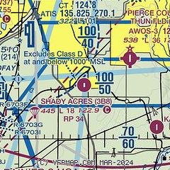
| Sectional chart |
|---|
|
| Airport distance calculator |
|---|
|
|
| Sunrise and sunset |
|---|
|
Times for 03-Jun-2026
| | Local
(UTC-7) | | Zulu
(UTC) |
|---|
| Morning civil twilight | | 04:39 | | 11:39 |
| Sunrise | | 05:18 | | 12:18 |
| Sunset | | 20:57 | | 03:57 |
| Evening civil twilight | | 21:36 | | 04:36 |
|
| Current date and time |
|---|
| Zulu (UTC) | 03-Jun-2026 22:03:28 |
|---|
| Local (UTC-7) | 03-Jun-2026 15:03:28 |
|---|
|
| METAR |
|---|
KPLU
4nm NE | 032155Z AUTO 00000KT 10SM BKN080 OVC090 20/07 A3009 RMK AO2
|
KTCM
5nm NW | 032155Z AUTO 27007G18KT 10SM OVC080 21/06 A3008 RMK AO2 SLP189 T02130064 $
|
KGRF
8nm W | 032055Z AUTO 19010G14KT 10SM OVC090 21/07 A3006 RMK AO2 LTG DSNT NE SLP182 60000 T02130071 51010 $
|
KTIW
15nm NW | 032153Z VRB06G14KT 10SM OVC080 19/08 A3009 RMK AO2 SLP188 T01890078
|
|
| TAF |
|---|
KTCM
5nm NW | 031300Z 0313/0419 22010G15KT 9999 VCSH BKN120 QNH3003INS BECMG 0319/0320 25010KT 9999 NSW FEW020 OVC075 620804 QNH3007INS BECMG 0323/0324 24010G15KT 9999 OVC050 QNH3007INS BECMG 0407/0408 22010G15KT 9999 BKN015 OVC030 QNH3015INS BECMG 0415/0416 24010KT 9999 BKN025 QNH3017INS TX20/0323Z TN11/0413Z
|
KGRF
8nm W | 031300Z 0313/0419 28006KT 9999 SCT200 QNH2992INS BECMG 0316/0317 25010KT 9000 -DZ BKN050 OVC100 620802 QNH3003INS BECMG 0319/0320 24010KT 9999 NSW BKN045 QNH3008INS BECMG 0322/0323 24010G20KT 9999 BKN045 QNH3006INS BECMG 0404/0405 25010G20KT 9999 BKN020 QNH3010INS BECMG 0416/0417 25010G20KT 9999 BKN040 QNH3016INS TX22/0405Z TN14/0313Z
|
|
| NOTAMs |
|---|
NOTAMs are issued by the DoD/FAA and will open in a separate window not controlled by AirNav.
|
|

