FAA INFORMATION EFFECTIVE 19 MARCH 2026
Location
| FAA Identifier: | 3R9 |
| Lat/Long: | 30-21-26.9680N 097-59-40.0840W
30-21.449467N 097-59.668067W
30.3574911,-97.9944678
(estimated) |
| Elevation: | 909.4 ft. / 277.2 m (surveyed) |
| Variation: | 04E (2015) |
| From city: | 2 miles SW of LAKEWAY, TX |
| Time zone: | UTC -5 (UTC -6 during Standard Time) |
| Zip code: | 78734 |
Airport Operations
| Airport use: | Open to the public |
| Activation date: | 01/1963 |
| Control tower: | no |
| ARTCC: | HOUSTON CENTER |
| FSS: | SAN ANGELO FLIGHT SERVICE STATION |
| NOTAMs facility: | SJT (NOTAM-D service available) |
| Attendance: | UNATNDD
ARPT CLSD SS-SR. |
| Wind indicator: | yes |
| Segmented circle: | no |
| Landing fee: | yes, LNDG FEE FOR TURBINES & JETS. OVNGT TIEDOWN FEE. |
Airport Communications
| CTAF/UNICOM: | 123.0 |
| AUSTIN APPROACH: | 119.0 |
| AUSTIN DEPARTURE: | 119.0 |
| AEROZ DP: | 119.0 |
| BLEWE STAR: | 127.225 |
| BNDIA DP: | 119.0 |
| ELOEL DP: | 119.0 |
| GABOO STAR: | 127.225 |
| ILEXY DP: | 119.0 |
| KALLA STAR: | 119.0 |
| MUCKY DP: | 119.0 |
| POTRR STAR: | 127.225 |
| SAYBR DP: | 119.0 |
| SZAGI STAR: | 118.15 ;SFC-7000 FT 119.0 ;8,000-12,000 FT |
| WX AWOS-3PT at RYW (9 nm N): | 119.375 (512-267-1365) |
| WX ASOS at AUS (19 nm SE): | PHONE 512-369-7881 |
Nearby radio navigation aids
| VOR radial/distance | | VOR name | | Freq | | Var |
|---|
| CWKr261/24.1 | | CENTEX VORTAC | | 112.80 | | 06E |
| STVr068/37.9 | | STONEWALL VORTAC | | 113.80 | | 08E |
Airport Services
| Fuel available: | 100LL
100LL:FUEL SELF-SVC. |
| Parking: | tiedowns |
Runway Information
Runway 16/34
| Dimensions: | 3930 x 70 ft. / 1198 x 21 m |
| Surface: | asphalt, in fair condition
RWY RISES FM S TO N 32 FT. ACFT NOT VISIBLE AT OPPOSITE END. |
| Weight bearing capacity: | |
| RUNWAY 16 | | RUNWAY 34 |
| Latitude: | 30-21.767418N | | 30-21.131500N |
| Longitude: | 097-59.740818W | | 097-59.595333W |
| Elevation: | 882.4 ft. | | 909.3 ft. |
| Traffic pattern: | left | | left |
| Runway heading: | 165 magnetic, 169 true | | 345 magnetic, 349 true |
| Displaced threshold: | 782 ft. | | 624 ft. |
| Markings: | basic, in good condition | | basic, in good condition |
| Touchdown point: | yes, no lights | | yes, no lights |
| Obstructions: | 30 ft. tree, 205 ft. from runway
3 FT BANK 70 FT R OF CNTRLN 0-199 FT DSTC. | | 34 ft. trees, 201 ft. from runway
34 FT TREES 75--200 FT DSTC ACRS APCH. |
Airport Ownership and Management from official FAA records
| Ownership: | Privately-owned |
| Owner: | LAKEWAY AIRPARK INC
115 FLYING SCOT
LAKEWAY, TX 78734
Phone 512-261-4385 |
| Manager: | AIRPARK BOARD
115 FLYING SCOT
LAKEWAY, TX 78734
Phone 512-261-4385 |
Additional Remarks
| - | NO TGLS. NO LOW PASSES |
| - | MNTN RWY HDG TIL 1 MI & 400 FT AGL (1300 FT MSL) FOR NOISE ABATEMENT. |
| - | BLDGS, TREES & PARKED ACFT NEAR RWY. |
| - | 2-WAY RADIO COM RQRD ON CTAF. |
| - | 3 FT NON-FRANGIBLE SIGNS 10 FT FM RWY EDGE AT DSPLCD THR, BOTH SIDES. |
| - | FOR CD CTC AUSTIN APCH AT 512-369-7865. |
| - | NO COML OPNS PER CITY ORDINANCE. |
| - | RWY 34, 30 FT MKD PWR LINES ACRS APCH 155 FT DSTC. |
| - | RWY 34, 30 FT MKD ELEC TMTN LINES CRS THRU APCH 200 FT DSTC. |
| - | NO NGT OPNS PER CITY ORDINANCE. |
| - | ARPT WX SR-SS CLICK MIKE 5X ON CTAF. |
| - | DEER ON & INVOF ARPT. |
| - | NUMEROUS OBJECTS IN PRIM SFC. |
| - | ARPT OPNS LTD TO ACFT WITH MAX GWT OF 12500 LBS OR LESS BY CITY ORDINANCE.. |
| - | ULTRALIGHT AND GLIDER OPNS PROHIBITED. |
Instrument Procedures
NOTE: All procedures below are presented as PDF files. If you need a reader for these files, you should download the free Adobe Reader.NOT FOR NAVIGATION. Please procure official charts for flight.
FAA instrument procedures published for use from 19 March 2026 at 0901Z to 16 April 2026 at 0900Z.
STARs - Standard Terminal Arrivals |
|---|
| BLEWE FIVE | |
download (158KB) |
| GABOO ONE (RNAV) | |
download (128KB) |
| POTRR TWO (RNAV) | |
download (166KB) |
| SZAGI THREE (RNAV) | |
download (196KB) |
IAPs - Instrument Approach Procedures |
|---|
| RNAV (GPS) RWY 16 | |
download (208KB) |
Departure Procedures |
|---|
| AEROZ TWO (RNAV) | |
download (169KB) |
| BNDIA THREE (RNAV) | |
download (157KB) |
| ELOEL THREE (RNAV) | |
download (182KB) |
| ILEXY FOUR (RNAV) | |
download (199KB) |
| MUCKY THREE (RNAV) | |
download (155KB) |
| SAYBR THREE (RNAV) | |
download (166KB) |
| NOTE: Special Take-Off Minimums/Departure Procedures apply | |
download (141KB) |
Other nearby airports with instrument procedures:
KRYW - Lago Vista TX/Rusty Allen Airport (9 nm N)
KAUS - Austin-Bergstrom International Airport (19 nm SE)
KEDC - Austin Executive Airport (22 nm E)
KGTU - Georgetown Executive Airport (25 nm NE)
KBMQ - Burnet Municipal Airport/Kate Craddock Field (26 nm NW)
|
|

Road maps at:
MapQuest
Bing
Google
| Aerial photo |
|---|
WARNING: Photo may not be current or correct

Do you have a better or more recent aerial photo of Lakeway Airpark that you would like to share? If so, please send us your photo.
|
| Sectional chart |
|---|
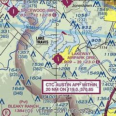
|
| Airport distance calculator |
|---|
|
|
| Sunrise and sunset |
|---|
|
Times for 21-Mar-2026
| | Local
(UTC-5) | | Zulu
(UTC) |
|---|
| Morning civil twilight | | 07:12 | | 12:12 |
| Sunrise | | 07:36 | | 12:36 |
| Sunset | | 19:43 | | 00:43 |
| Evening civil twilight | | 20:07 | | 01:07 |
|
| Current date and time |
|---|
| Zulu (UTC) | 21-Mar-2026 13:37:33 |
|---|
| Local (UTC-5) | 21-Mar-2026 08:37:33 |
|---|
|
| METAR |
|---|
KRYW
9nm N | 211315Z AUTO 21006KT 10SM CLR 19/11 A3003 RMK AO2 T01850113
|
KATT
16nm E | 211251Z AUTO 00000KT 10SM CLR 15/14 A3001 RMK AO2 SLP153 T01500139 $
|
KAUS
16nm E | 211253Z 15003KT 9SM CLR 11/11 A3000 RMK AO2 SLP153 T01110111 $
|
|
| TAF |
|---|
KAUS
16nm E | 211120Z 2112/2218 18004KT P6SM SKC FM211700 18011G21KT P6SM SKC FM220000 18009KT P6SM SKC
|
|
| NOTAMs |
|---|
NOTAMs are issued by the DoD/FAA and will open in a separate window not controlled by AirNav.
|
|


