FAA INFORMATION EFFECTIVE 14 MAY 2026
Location
| FAA Identifier: | 57B |
| Lat/Long: | 44-18-08.9000N 068-54-38.1000W
44-18.148333N 068-54.635000W
44.3024722,-68.9105833
(estimated) |
| Elevation: | 88.3 ft. / 26.9 m (surveyed) |
| Variation: | 18W (1985) |
| From city: | 1 mile W of ISLESBORO, ME |
| Time zone: | UTC -4 (UTC -5 during Standard Time) |
| Zip code: | 04848 |
Airport Operations
| Airport use: | Open to the public |
| Activation date: | 01/1966 |
| Control tower: | no |
| ARTCC: | BOSTON CENTER |
| FSS: | BANGOR FLIGHT SERVICE STATION |
| NOTAMs facility: | BGR (NOTAM-D service available) |
| Attendance: | UNATNDD |
| Wind indicator: | yes |
| Segmented circle: | no |
Airport Communications
| CTAF: | 122.9 |
| BANGOR APPROACH: | 118.925 |
| BANGOR DEPARTURE: | 118.925 |
| WX AWOS-AV at BST (8 nm NW): | 122.975 (207-930-7071) |
| WX AWOS-3PT at RKD (17 nm SW): | 119.025 (207-594-7946) |
Nearby radio navigation aids
| VOR radial/distance | | VOR name | | Freq | | Var |
|---|
| BGRr202/32.4 | | BANGOR VORTAC | | 114.80 | | 19W |
| AUGr110/38.1 | | AUGUSTA VOR/DME | | 114.95 | | 18W |
| NDB name | | Hdg/Dist | | Freq | | Var | | ID |
|---|
| BURNHAM | | 159/30.5 | | 348 | | 18W | | BUP | -... ..- .--. |
Airport Services
| Parking: | tiedowns |
| Airframe service: | NONE |
| Powerplant service: | NONE |
| Bulk oxygen: | NONE |
Runway Information
Runway 1/19
| Dimensions: | 2400 x 50 ft. / 732 x 15 m |
| Surface: | asphalt, in excellent condition |
| RUNWAY 1 | | RUNWAY 19 |
| Latitude: | 44-17.954468N | | 44-18.340515N |
| Longitude: | 068-54.577258W | | 068-54.693083W |
| Elevation: | 70.9 ft. | | 88.3 ft. |
| Traffic pattern: | left | | left |
| Displaced threshold: | 250 ft. | | no |
| Markings: | basic, in fair condition | | basic, in fair condition |
| Runway end identifier lights: | no | | no |
| Obstructions: | 50 ft. trees, 201 ft. from runway, 90 ft. left and right of centerline
35-45 FT TREES, 0- 200 FT FM THR, 90-125 FT L OF CNTRLN AND 120-125 FT L AND R OF CNTRLN. | | 10 ft. road, 201 ft. from runway, 107 ft. right of centerline
10 FT ROAD, 107 FT R OF CNTRLN; 45 FT TREES 100-200 FT FM THR, 120 FT R OF CNTRLN; 10-20 FT BRUSH 100-200 FT FM THR, 105 FT L OF CNTRLN. |
Helipad H1
| Dimensions: | 40 x 40 ft. / 12 x 12 m |
| Surface: | asphalt, in excellent condition |
| Latitude: | 44-18.325000N | | |
| Longitude: | 068-54.713333W | | |
| Elevation: | 88.3 ft. | | |
| Traffic pattern: | left | | left |
| Markings: | basic, in good condition | | |
Airport Ownership and Management from official FAA records
| Ownership: | Publicly-owned |
| Owner: | TOWN OF ISLESBORO
PO BOX 76
ISLEBORO, ME 04848
Phone 207-734-2253 |
| Manager: | JANET R. ANDERSON
PO BOX 76
ISLESBORO, ME 04848
Phone 207-734-2253
TOWN MGR OF ISLEBORO. |
Additional Remarks
| - | ARPT CLSD NGTS, DAYTIME USE ONLY. |
| - | DEER ON & INVOF ARPT. |
| - | NO TGL OPS. |
| - | NOISE ABATEMENT - MNTN RWY HDG TO 1000 FT AGL. |
| - | HELIPAD: NW CORNER OF RAMP. |
| - | FOR CD CTC BANGOR APCH AT 207-561-2500 EXTN 1. |
Instrument Procedures
There are no published instrument procedures at 57B.
Some nearby airports with instrument procedures:
KBST - Belfast Municipal Airport (8 nm NW)
KRKD - Knox County Regional Airport (17 nm SW)
KBHB - Hancock County/Bar Harbor Airport (25 nm E)
KBGR - Bangor International Airport (31 nm N)
2B7 - Pittsfield Municipal Airport (34 nm NW)
|
|

Road maps at:
MapQuest
Bing
Google
| Aerial photo |
|---|
WARNING: Photo may not be current or correct
 Photo by Pete Chaisson Portland Flight Services
Photo taken 03-Oct-2014
looking north-northwest.
Photo by Pete Chaisson Portland Flight Services
Photo taken 03-Oct-2014
looking north-northwest.
Do you have a better or more recent aerial photo of Islesboro Airport that you would like to share? If so, please send us your photo.
|
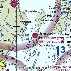
| Sectional chart |
|---|
|
| Airport distance calculator |
|---|
|
|
| Sunrise and sunset |
|---|
|
Times for 19-May-2026
| | Local
(UTC-4) | | Zulu
(UTC) |
|---|
| Morning civil twilight | | 04:31 | | 08:31 |
| Sunrise | | 05:06 | | 09:06 |
| Sunset | | 19:59 | | 23:59 |
| Evening civil twilight | | 20:33 | | 00:33 |
|
| Current date and time |
|---|
| Zulu (UTC) | 19-May-2026 14:03:33 |
|---|
| Local (UTC-4) | 19-May-2026 10:03:33 |
|---|
|
| METAR |
|---|
KRKD
16nm SW | 191356Z AUTO VRB04KT 10SM CLR 23/15 A2996 RMK AO2 SLP144 T02330150
|
KBHB
25nm E | 191356Z AUTO 18007KT 10SM CLR 19/12 A2995 RMK AO2 SLP142 T01890122 $
|
KBGR
30nm N | 191353Z 23005KT 10SM FEW250 22/11 A2993 RMK AO2 SLP132 T02170111
|
|
| TAF |
|---|
KRKD
16nm SW | 191120Z 1912/2012 23007KT P6SM FEW004 FEW250 FM191800 23011KT P6SM VCSH SCT050 BKN080 FM200000 25005KT P6SM FEW004 FEW250
|
|
| NOTAMs |
|---|
NOTAMs are issued by the DoD/FAA and will open in a separate window not controlled by AirNav.
|
|

