FAA INFORMATION EFFECTIVE 14 MAY 2026
Location
| FAA Identifier: | BGR |
| Lat/Long: | 44-48-26.8000N 068-49-41.3000W
44-48.446667N 068-49.688333W
44.8074444,-68.8281389
(estimated) |
| Elevation: | 192.1 ft. / 58.6 m (surveyed) |
| Variation: | 16W (2020) |
| From city: | 3 miles W of BANGOR, ME |
| Time zone: | UTC -4 (UTC -5 during Standard Time) |
| Zip code: | 04401 |
Airport Operations
| Airport use: | Open to the public |
| Activation date: | 04/1940 |
| Control tower: | yes |
| ARTCC: | BOSTON CENTER |
| FSS: | BANGOR FLIGHT SERVICE STATION |
| NOTAMs facility: | BGR (NOTAM-D service available) |
| Attendance: | CONTINUOUS |
| Wind indicator: | lighted |
| Segmented circle: | no |
| Beacon: | white-green (lighted land airport)
Operates sunset to sunrise. |
| Landing fee: | yes |
| Fire and rescue: | ARFF index B |
| Airline operations: | ARFF INDEX B WITH INDEX E CAPABILITIES AVBL 24/7. |
| International operations: | customs landing rights airport |
Airport Communications
| UNICOM: | 122.95 |
| ATIS: | 127.75 |
| WX ASOS: | 127.75 (207-561-2515) |
| BANGOR GROUND: | 121.9 348.6 |
| BANGOR TOWER: | 120.7 233.7 |
| BANGOR APPROACH: | 118.925 239.3 124.5 |
| BANGOR DEPARTURE: | 118.925 239.3 124.5 |
| CLEARANCE DELIVERY: | 135.9 348.6 |
| CLASS C: | 118.925 239.3 |
| CLASS C/S: | 124.5 |
| EMERG: | 121.5 243.0 |
| IC: | 118.925 239.3 |
| NG OPS: | 41.2 |
- (ATIS PHONE NR) OR DSN 598-7010.
Nearby radio navigation aids
| VOR radial/distance | | VOR name | | Freq | | Var |
|---|
| BGRr156/2.8 | | BANGOR VORTAC | | 114.80 | | 19W |
| NDB name | | Hdg/Dist | | Freq | | Var | | ID |
|---|
| BURNHAM | | 092/23.5 | | 348 | | 18W | | BUP | -... ..- .--. |
Airport Services
| Fuel available: | 100LL JET-A |
| Parking: | hangars and tiedowns |
| Airframe service: | MAJOR |
| Powerplant service: | MAJOR |
| Bottled oxygen: | LOW |
| Bulk oxygen: | LOW |
Runway Information
Runway 15/33
| Dimensions: | 11440 x 200 ft. / 3487 x 61 m |
| Surface: | asphalt/grooved, in good condition |
| Weight bearing capacity: | | Single wheel: | 100.0 | | Double wheel: | 210.0 | | Double tandem: | 400.0 |
|
| Runway edge lights: | high intensity |
| RUNWAY 15 | | RUNWAY 33 |
| Latitude: | 44-49.102282N | | 44-47.790227N |
| Longitude: | 068-50.635870W | | 068-48.739363W |
| Elevation: | 192.1 ft. | | 162.9 ft. |
| Traffic pattern: | left | | left |
| Runway heading: | 150 magnetic, 134 true | | 330 magnetic, 314 true |
| Declared distances: | TORA:11440 TODA:11440 ASDA:11440 LDA:11440 | | TORA:11440 TODA:11440 ASDA:11440 LDA:11440 |
| Markings: | precision, in good condition | | precision, in good condition |
| Visual slope indicator: | 4-light PAPI on left (3.00 degrees glide path) | | 4-light PAPI on left (3.00 degrees glide path) |
| RVR equipment: | touchdown, midfield, rollout | | touchdown, midfield, rollout |
| Approach lights: | ALSF2: standard 2,400 foot high intensity approach lighting system with centerline sequenced flashers (category II or III) | | MALSR: 1,400 foot medium intensity approach lighting system with runway alignment indicator lights |
| Centerline lights: | yes | | yes |
| Touchdown point: | yes, lighted | | yes, no lights |
| Instrument approach: | ILS/DME | | ILS/DME |
| Obstructions: | none | | 76 ft. trees, 2800 ft. from runway, 34:1 slope to clear |
Helipad H1
| Dimensions: | 100 x 100 ft. / 30 x 30 m |
| Surface: | concrete, in fair condition |
| Latitude: | 44-48.310167N | | |
| Longitude: | 068-48.979667W | | |
| Elevation: | 148.0 ft. | | |
| Traffic pattern: | left | | left |
| Markings: | none | | |
Airport Ownership and Management from official FAA records
| Ownership: | Publicly-owned |
| Owner: | CITY OF BANGOR
73 HARLOW ST
BANGOR, ME 04401
Phone 207-992-4200 |
| Manager: | JOSE F SAAVEDRA
BANGOR INTERNATIONAL ARPT, 287 GODFREY BLVD
BANGOR, ME 04401
Phone 207-992-4600 |
Additional Remarks
| A39-15/33 | PCR VALUE: 735/R/B/W/U |
| - | ANG: CAUTION: BASH PHASE II PERIOD SEP-NOV, APR-MAY. EXPECT INCREASED BIRD ACTIVITY. CONTACT BASE OPS/COMMAND POST/SOF FOR CURRENT BIRDWATCH COND. |
| - | FUEL: A++ (MIL). |
| - | SVC MIL-FLUID: OFF-BASE CONTRACTED LOX AVBL H24-RQR 24 HR NOTICE. |
| - | ANG: OPR 1100-1930Z++ MON-FRI, CLSD WKEND AND HOL. PPR RQRD FOR ANG RAMP. CTC AFLD MGMT DSN 698-7232, C207-404-7232 FOR PPR DURG OPR HRS. PRE-COORD ALL TRNSPN RQMNTS AND HAZ CARGO WITH PPR REQ. |
| - | ANG: PPR VALID +/- 1 HR UNLESS PRIOR CDN. 3 HR OUT CALL, 30 MIN OUT CALL 311.0 TO CFM CSTMS/AG AND TRAN SVC. COMMAND POST C207-404-7788 H24. |
| - | ANG: TRANSIENT ACFT MAY BE DIVERTED TO CIVILIAN SIDE DURING NON-DUTY HRS & WEEKENDS. FEE REQUIRED; NO ANG TRANSIENT ALERT. |
| - | TFC PAT: RWY 33 LEFT TFC, TURBO JET TFC 2000' MSL UNLESS OTHERWISE INSTR. |
| - | MISC: RWY 15-33 GROOVED. |
| - | ARNG: OPR 1230-2100Z++ MON-FRI EXC HOL. LTD MAINT. J8. PPR MAY-OCT SVC DSN 626-1100. |
Instrument Procedures
NOTE: All procedures below are presented as PDF files. If you need a reader for these files, you should download the free Adobe Reader.NOT FOR NAVIGATION. Please procure official charts for flight.
FAA instrument procedures published for use from 14 May 2026 at 0901Z to 11 June 2026 at 0900Z.
IAPs - Instrument Approach Procedures |
|---|
| HI-ILS Z OR LOC Z RWY 15 | |
download (239KB) |
| ILS OR LOC RWY 33 | |
download (344KB) |
| ILS Y OR LOC Y RWY 15 | |
download (295KB) |
| ILS RWY 33 (SA CAT I - II) | |
download (286KB) |
| ILS Y RWY 15 (CAT II - III) | |
download (253KB) |
| RNAV (GPS) RWY 15 | |
download (245KB) |
| RNAV (GPS) RWY 33 | |
download (258KB) |
| Radar Approach Procedures available | |
download (94KB) |
| NOTE: Special Alternate Minimums apply | |
download (88KB) |
Departure Procedures |
|---|
| BANGOR FIVE | |
download (167KB) |
| NOTE: Special Take-Off Minimums/Departure Procedures apply | |
download (295KB) |
Other nearby airports with instrument procedures:
KOLD - Dewitt Field/Old Town Municipal Airport (11 nm NE)
1B0 - Dexter Regional Airport (21 nm NW)
2B7 - Pittsfield Municipal Airport (23 nm W)
KBST - Belfast Municipal Airport (25 nm S)
KBHB - Hancock County/Bar Harbor Airport (29 nm SE)
|
|

Road maps at:
MapQuest
Bing
Google
| Aerial photo |
|---|
WARNING: Photo may not be current or correct
 Photo taken 06-Jan-2011
looking northwest.
Photo taken 06-Jan-2011
looking northwest.
Do you have a better or more recent aerial photo of Bangor International Airport that you would like to share? If so, please send us your photo.
|
| Sectional chart |
|---|
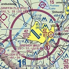
|
CAUTION: Diagram may not be current
 Download PDF
of official airport diagram from the FAA
| Airport distance calculator |
|---|
|
|
| Sunrise and sunset |
|---|
|
Times for 09-Jun-2026
| | Local
(UTC-4) | | Zulu
(UTC) |
|---|
| Morning civil twilight | | 04:14 | | 08:14 |
| Sunrise | | 04:50 | | 08:50 |
| Sunset | | 20:19 | | 00:19 |
| Evening civil twilight | | 20:55 | | 00:55 |
|
| Current date and time |
|---|
| Zulu (UTC) | 09-Jun-2026 17:18:54 |
|---|
| Local (UTC-4) | 09-Jun-2026 13:18:54 |
|---|
|
| METAR |
|---|
| KBGR | 091653Z 27010KT 10SM FEW060 FEW250 28/13 A2998 RMK AO2 SLP149 T02830133 $
|
|
| TAF |
|---|
| KBGR | 091120Z 0912/1012 25006KT P6SM SCT200 FM091400 28009G16KT P6SM SCT150 FM100000 VRB02KT P6SM FEW200
|
|
| NOTAMs |
|---|
NOTAMs are issued by the DoD/FAA and will open in a separate window not controlled by AirNav.
|
|


