FAA INFORMATION EFFECTIVE 16 APRIL 2026
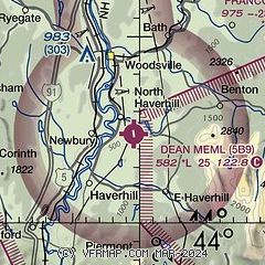
Location
| FAA Identifier: | 5B9 |
| Lat/Long: | 44-04-48.6222N 072-00-27.9357W
44-04.810370N 072-00.465595W
44.0801728,-72.0077599
(estimated) |
| Elevation: | 581.7 ft. / 177.3 m (surveyed) |
| Variation: | 16W (2005) |
| From city: | 3 miles NE of HAVERHILL, NH |
| Time zone: | UTC -4 (UTC -5 during Standard Time) |
| Zip code: | 03774 |
Airport Operations
| Airport use: | Open to the public |
| Activation date: | 07/1902 |
| Control tower: | no |
| ARTCC: | BOSTON CENTER |
| FSS: | BANGOR FLIGHT SERVICE STATION |
| NOTAMs facility: | BGR (NOTAM-D service available) |
| Attendance: | SATURDAY 0900-1200 |
| Wind indicator: | lighted |
| Segmented circle: | no |
| Lights: | ACTVT LIRL RWY 01/19 & WINDSOCK - CTAF. |
Airport Communications
- APCH/DEP SVC PRVDD BY BOSTON ARTCC ON FREQS 135.7/282.2 (MONTPELIER RCAG).
Nearby radio navigation aids
| VOR radial/distance | | VOR name | | Freq | | Var |
|---|
| MPVr107/19.0 | | MONTPELIER VOR/DME | | 116.90 | | 16W |
| NDB name | | Hdg/Dist | | Freq | | Var | | ID |
|---|
| MAHN | | 236/21.9 | | 386 | | 17W | | GMA | --. -- .- |
| HANOVER | | 033/23.8 | | 276 | | 15W | | LAH | .-.. .- .... |
Airport Services
| Fuel available: | 100LL
100LL:FUEL AVBL 24 HRS. |
| Parking: | tiedowns |
| Airframe service: | NONE |
| Powerplant service: | NONE |
| Bottled oxygen: | NONE |
| Bulk oxygen: | NONE |
Runway Information
Runway 1/19
| Dimensions: | 2511 x 58 ft. / 765 x 18 m |
| Surface: | asphalt, in fair condition |
| Weight bearing capacity: | |
| Runway edge lights: | low intensity
NSTD SPACING, FIRST 185 FT RWY 01 UNLGTD. |
| RUNWAY 1 | | RUNWAY 19 |
| Latitude: | 44-04.605733N | | 44-05.015008N |
| Longitude: | 072-00.425992W | | 072-00.505202W |
| Elevation: | 581.7 ft. | | 546.0 ft. |
| Traffic pattern: | left | | left |
| Runway heading: | 008 magnetic, 352 true | | 188 magnetic, 172 true |
| Displaced threshold: | 185 ft. | | no |
| Markings: | basic, in fair condition | | nonprecision, in fair condition |
| Touchdown point: | yes, no lights | | yes, no lights |
| Obstructions: | 100 ft. trees, 368 ft. from runway, 257 ft. right of centerline, 1:1 slope to clear | | 36 ft. pole, lighted, 244 ft. from runway, 171 ft. left of centerline, 1:1 slope to clear |
Airport Ownership and Management from official FAA records
| Ownership: | Publicly-owned |
| Owner: | TOWN OF HAVERHILL
2975 DARTMOUTH COLLEGE HWY
N. HAVERHILL, NH 03774
Phone 603-787-6800
DEAN MEMORIAL ARPT COMMISSION. |
| Manager: | DENNIS CUNNINGHAM
992 COUNTY ROAD
N. HAVERHILL, NH 03774
Phone 603-346-0445 |
Additional Remarks
| - | FOR WINTER CONDS CALL 603-346-0445 24 HRS BFR USE. |
| - | FOR CD CTC BOSTON ARTCC AT 603-879-6859. |
| - | COLD TEMPERATURE AIRPORT. ALTITUDE CORRECTION REQUIRED AT OR BELOW -27C. |
Instrument Procedures
NOTE: All procedures below are presented as PDF files. If you need a reader for these files, you should download the free Adobe Reader.NOT FOR NAVIGATION. Please procure official charts for flight.
FAA instrument procedures published for use from 16 April 2026 at 0901Z to 14 May 2026 at 0900Z.
IAPs - Instrument Approach Procedures |
|---|
| RNAV (GPS) RWY 19 | |
download (268KB) |
| NOTE: Special Take-Off Minimums/Departure Procedures apply | |
download (494KB) |
Other nearby airports with instrument procedures:
KMPV - Edward F Knapp State Airport (25 nm W)
KHIE - Mount Washington Regional Airport (26 nm NE)
KCDA - Caledonia County Airport (29 nm N)
KLEB - Lebanon Municipal Airport (30 nm SW)
KMVL - Morrisville-Stowe State Airport (38 nm NW)
|
|

Road maps at:
MapQuest
Bing
Google
| Aerial photo |
|---|
WARNING: Photo may not be current or correct
 Photo courtesy of Aerial Design Photography
Do you have a better or more recent aerial photo of Dean Memorial Airport that you would like to share? If so, please send us your photo.
|
| Sectional chart |
|---|
|
| Airport distance calculator |
|---|
|
|
| Sunrise and sunset |
|---|
|
Times for 08-May-2026
| | Local
(UTC-4) | | Zulu
(UTC) |
|---|
| Morning civil twilight | | 04:58 | | 08:58 |
| Sunrise | | 05:31 | | 09:31 |
| Sunset | | 19:58 | | 23:58 |
| Evening civil twilight | | 20:31 | | 00:31 |
|
| Current date and time |
|---|
| Zulu (UTC) | 08-May-2026 21:35:56 |
|---|
| Local (UTC-4) | 08-May-2026 17:35:56 |
|---|
|
| METAR |
|---|
K1V4
20nm N | 082054Z AUTO 11/M05 A2978 RMK AO1 SLP089 T01111050 51000
|
K1P1
21nm SE | 082115Z AUTO 29006KT 10SM OVC080 11/M05 A2979 RMK AO2 T01141050
|
KMPV
25nm W | 082051Z AUTO 32011G17KT 10SM OVC095 10/M06 A2983 RMK AO2 SLP111 T01001056 55003
|
KHIE
26nm NE | 082052Z AUTO 34009KT 10SM BKN060 BKN075 OVC090 09/M04 A2979 RMK AO2 SLP097 T00891039 50007 $
|
KCDA
29nm N | 082115Z AUTO 24006G14KT 10SM SCT055 SCT080 OVC090 09/M04 A2981 RMK AO2 T00931037
|
KLEB
30nm SW | 082053Z VRB06KT 10SM BKN095 13/M03 A2979 RMK AO2 SLP089 T01331033 55004
|
KMWN
33nm E | 081958Z 27031G37KT 45SM -SHSN BCFG FEW000 BKN005 OVC010 M06/M08 RMK VIRGA DSNT NW-N BCFG FEW000 SH DSNT NE S-SW BLSN AT STA BCFG INTMT
|
KMVL
36nm NW | 082054Z AUTO VRB04KT 10SM SCT065 OVC095 10/M04 A2981 RMK AO2 SLP100 60000 T01001044 55001
|
KLCI
40nm SE | 082056Z AUTO 27011KT 10SM BKN095 12/M05 A2979 RMK AO2 SLP093 T01171050 53002
|
|
| TAF |
|---|
KMPV
25nm W | 081720Z 0818/0918 33008G14KT P6SM OVC060 FM090000 VRB03KT P6SM SCT060 FM091500 17008G14KT P6SM OVC180
|
KHIE
26nm NE | 081735Z 0818/0918 28009KT P6SM VCSH BKN045 FM082200 VRB03KT P6SM FEW250
|
KLEB
30nm SW | 081735Z 0818/0918 27008G14KT P6SM BKN060 FM082300 VRB03KT P6SM SCT250
|
|
| NOTAMs |
|---|
NOTAMs are issued by the DoD/FAA and will open in a separate window not controlled by AirNav.
|
|

