FAA INFORMATION EFFECTIVE 14 MAY 2026
Location
| FAA Identifier: | 60J |
| Lat/Long: | 33-54-33.5520N 078-26-04.8680W
33-54.559200N 078-26.081133W
33.9093200,-78.4346856
(estimated) |
| Elevation: | 32.7 ft. / 10.0 m (surveyed) |
| Variation: | 07W (1985) |
| From city: | 1 mile N of OCEAN ISLE BEACH, NC |
| Time zone: | UTC -4 (UTC -5 during Standard Time) |
| Zip code: | 28470 |
Airport Operations
| Airport use: | Open to the public |
| Activation date: | 04/1971 |
| Control tower: | no |
| ARTCC: | JACKSONVILLE CENTER |
| FSS: | RALEIGH FLIGHT SERVICE STATION |
| NOTAMs facility: | RDU (NOTAM-D service available) |
| Attendance: | JUN-AUG TUE-SUN 1000-1700, SEP-MAY SAT-SUN 1000-1600
MON-FRI ON CALL (910-575-7575); FOR SVC AFT HRS CALL 845-629-0626.
24 HR PILOT LOUNGE - EMERG FREQ ALLOWS ACES. |
| Wind indicator: | lighted |
| Segmented circle: | no |
| Lights: | ACTVT MIRL RWY 06/24 - CTAF. PAPI RWY 06 & RWY 24 OPER CONSLY. |
Airport Communications
| CTAF: | 122.9 |
| WX ASOS at CRE (16 nm W): | 119.625 (843-361-2802) |
| WX AWOS-3P at SUT (18 nm E): | 124.175 (910-457-1710) |
Nearby radio navigation aids
| VOR radial/distance | | VOR name | | Freq | | Var |
|---|
| CREr071/15.5 | | GRAND STRAND VORTAC | | 114.40 | | 03W |
| ILMr233/38.5 | | WILMINGTON VORTAC | | 117.00 | | 07W |
Airport Services
| Fuel available: | 100LL
100LL:24 HR SELF SVC FUEL WITH CC. |
| Parking: | tiedowns |
| Airframe service: | NONE |
| Powerplant service: | NONE |
| Bottled oxygen: | NONE |
| Bulk oxygen: | NONE |
Runway Information
Runway 6/24
| Dimensions: | 4198 x 75 ft. / 1280 x 23 m |
| Surface: | asphalt, in good condition |
| Weight bearing capacity: | |
| Runway edge lights: | medium intensity |
| RUNWAY 6 | | RUNWAY 24 |
| Latitude: | 33-54.360720N | | 33-54.757678N |
| Longitude: | 078-26.421155W | | 078-25.741093W |
| Elevation: | 32.4 ft. | | 28.9 ft. |
| Traffic pattern: | left | | left |
| Runway heading: | 062 magnetic, 055 true | | 242 magnetic, 235 true |
| Displaced threshold: | no | | 189 ft. |
| Markings: | nonprecision, in good condition | | nonprecision, in good condition |
| Visual slope indicator: | 2-light PAPI on left (3.67 degrees glide path) | | 2-light PAPI on left (3.00 degrees glide path) |
| Touchdown point: | yes, no lights | | yes, no lights |
| Obstructions: | 46 ft. tree, 917 ft. from runway, 187 ft. right of centerline, 15:1 slope to clear | | 64 ft. trees, 1359 ft. from runway, 5 ft. left of centerline, 18:1 slope to clear
RWY 24 APCH SLOPE 19:1 AT DSPLCD THR. |
Airport Ownership and Management from official FAA records
| Ownership: | Publicly-owned |
| Owner: | TOWN OF OCEAN ISLE BEACH
3 WEST 3RD STREET
OCEAN ISLE BEACH, NC 28469
Phone 910-579-2166 |
| Manager: | JUSTIN WHITESIDE
6070 BEACH DRIVE SW
OCEAN ISLE BEACH, NC 28469
Phone 910-599-5651 |
Additional Remarks
| - | PARL TWY BYD RAMP IS CLSD. |
| - | RWY 06 HAS 48 FT MKD TRSNL PLINE +/-1000 FT FROM THR. |
| - | FOR CD CTC MYRTLE BEACH APCH AT 843-477-2727 OR 843-477-2704, WHEN APCH CLSD CTC JACKSONVILLE ARTCC AT 904-845-1592. |
| - | CAUTION - DTFC SHUD VFY NO LTFC BFR BLOCKING ONLY RWY EXIT. |
Instrument Procedures
There are no published instrument procedures at 60J.
Some nearby airports with instrument procedures:
KCRE - Grand Strand Airport (16 nm W)
KSUT - Cape Fear Regional Jetport/Howie Franklin Field Airport (18 nm E)
5J9 - Twin City Airport (24 nm NW)
KCPC - Columbus County Regional Airport (26 nm NW)
KMYR - Myrtle Beach International Airport (28 nm SW)
|
|

Road maps at:
MapQuest
Bing
Google
| Aerial photo |
|---|
WARNING: Photo may not be current or correct
 Photo by Clif C. Simmons
Photo taken 13-Feb-2009
Photo by Clif C. Simmons
Photo taken 13-Feb-2009
Do you have a better or more recent aerial photo of Odell Williamson Municipal Airport that you would like to share? If so, please send us your photo.
|
| Sectional chart |
|---|
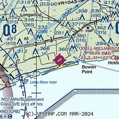
|
| Airport distance calculator |
|---|
|
|
| Sunrise and sunset |
|---|
|
Times for 25-May-2026
| | Local
(UTC-4) | | Zulu
(UTC) |
|---|
| Morning civil twilight | | 05:39 | | 09:39 |
| Sunrise | | 06:07 | | 10:07 |
| Sunset | | 20:14 | | 00:14 |
| Evening civil twilight | | 20:42 | | 00:42 |
|
| Current date and time |
|---|
| Zulu (UTC) | 25-May-2026 10:24:26 |
|---|
| Local (UTC-4) | 25-May-2026 06:24:26 |
|---|
|
| METAR |
|---|
KCRE
15nm W | 250953Z AUTO 19006KT 10SM FEW070 BKN090 25/23 A3012 RMK AO1 SLP200 T02500228
|
KSUT
18nm E | 250955Z AUTO 20004KT 10SM CLR 25/23 A3013 RMK AO2
|
KCPC
26nm NW | 250955Z AUTO 17003KT 7SM -RA CLR 23/22 A3014 RMK AO2 P0003 T02300218
|
KMYR
28nm SW | 250953Z 17005KT 10SM FEW065 24/23 A3013 RMK AO2 SLP203 T02440233 $
|
|
| TAF |
|---|
KCRE
15nm W | 250520Z 2506/2606 20010KT P6SM VCSH SCT015 BKN060 FM251300 20009KT P6SM SCT020 PROB30 2513/2515 4SM -RA BKN020 FM251500 18012KT P6SM SCT025 FM252000 19014KT P6SM FEW025
|
|
| NOTAMs |
|---|
NOTAMs are issued by the DoD/FAA and will open in a separate window not controlled by AirNav.
|
|

