FAA INFORMATION EFFECTIVE 14 MAY 2026
Location
| FAA Identifier: | CRW |
| Lat/Long: | 38-22-33.6470N 081-35-34.4170W
38-22.560783N 081-35.573617W
38.3760131,-81.5928936
(estimated) |
| Elevation: | 947.1 ft. / 288.7 m (surveyed) |
| Variation: | 06W (1985) |
| From city: | 3 miles E of CHARLESTON, WV |
| Time zone: | UTC -4 (UTC -5 during Standard Time) |
| Zip code: | 25311 |
Airport Operations
| Airport use: | Open to the public |
| Activation date: | 08/1947 |
| Control tower: | yes |
| ARTCC: | INDIANAPOLIS CENTER |
| FSS: | ELKINS FLIGHT SERVICE STATION [703-724-4288] |
| NOTAMs facility: | CRW (NOTAM-D service available) |
| Attendance: | CONTINUOUS |
| Wind indicator: | lighted |
| Segmented circle: | no |
| Beacon: | white-green (lighted land airport)
Operates sunset to sunrise. |
| Landing fee: | yes, LNDG FEE NOT APPLICABLE TO BASED ACFT. |
| Fire and rescue: | ARFF index B |
| International operations: | customs landing rights airport |
Airport Communications
| UNICOM: | 122.95 |
| ATIS: | 127.6 |
| WX ASOS: | PHONE 304-202-1064 |
| CHARLESTON GROUND: | 121.8 348.6 |
| CHARLESTON TOWER: | 125.7 257.8 |
| CHARLESTON APPROACH: | 119.2 ;SOUTH 124.1 ;NORTH 269.125 128.5 |
| CHARLESTON DEPARTURE: | 119.2 ;SOUTH 124.1 ;NORTH 269.125 128.5 |
| CLEARANCE DELIVERY: | 118.55 |
| CLASS C: | 119.2 ;SOUTH 124.1 ;NORTH 269.125 |
| EMERG: | 121.5 243.0 |
| IC: | 124.1 ;NORTH |
Nearby radio navigation aids
| VOR radial/distance | | VOR name | | Freq | | Var |
|---|
| HVQr082/8.5 | | CHARLESTON VOR/DME | | 117.40 | | 03W |
Airport Services
| Fuel available: | 100LL JET-A |
| Parking: | hangars and tiedowns |
| Airframe service: | MAJOR |
| Powerplant service: | MAJOR |
| Bottled oxygen: | NONE |
| Bulk oxygen: | NONE |
Runway Information
Runway 5/23
| Dimensions: | 6715 x 150 ft. / 2047 x 46 m |
| Surface: | asphalt/grooved, in good condition |
| Weight bearing capacity: | | Single wheel: | 120.0 | | Double wheel: | 250.0 | | Double tandem: | 389.0 | | Dual double tandem: | 917.0 |
|
| Runway edge lights: | high intensity |
| Runway edge markings: | RWY 23 MIL ASSAULT LDG ZONE AND PRECISION INSTR MARKINGS. |
| RUNWAY 5 | | RUNWAY 23 |
| Latitude: | 38-22.184500N | | 38-22.937015N |
| Longitude: | 081-36.088667W | | 081-35.058480W |
| Elevation: | 946.6 ft. | | 894.1 ft. |
| Traffic pattern: | left | | left |
| Runway heading: | 053 magnetic, 047 true | | 233 magnetic, 227 true |
| Displaced threshold: | no | | 500 ft. |
| Declared distances: | TORA:6715 TODA:6715 ASDA:6215 LDA:6215 | | TORA:6715 TODA:6715 ASDA:6715 LDA:6215 |
| Markings: | precision, in good condition | | NSTD, in good condition |
| Visual slope indicator: | 4-light PAPI on left (3.00 degrees glide path) | | 4-box VASI on right (3.00 degrees glide path) |
| RVR equipment: | touchdown, rollout | | touchdown, rollout |
| Approach lights: | | | ALSF1: standard 2,400 foot high intensity approach lighting system with centerline sequenced flashers (category I) |
| Runway end identifier lights: | yes | | |
| Centerline lights: | yes | | yes |
| Touchdown point: | yes, no lights | | yes, no lights |
| Instrument approach: | ILS/DME | | ILS/DME |
| Obstructions: | 223 ft. pole, lighted, 3950 ft. from runway, 950 ft. right of centerline, 16:1 slope to clear | | 136 ft. pole, lighted, 4300 ft. from runway, 100 ft. left of centerline, 30:1 slope to clear |
Airport Ownership and Management from official FAA records
| Ownership: | Publicly-owned |
| Owner: | CENTRAL WV REG ARPT AUTH
100 AIRPORT ROAD SUITE 175
CHARLESTON, WV 25311
Phone (304) 344-8033 |
| Manager: | MS DOMINIQUE RANIERI, ESQ., C.M.
100 AIRPORT ROAD SUITE 175
CHARLESTON, WV 25311
Phone 304-344-8033 |
Additional Remarks
| A39-05/23 | PCR VALUE: 950/F/D/X/T |
| E60-23 | ENGINEERED MATERIAL ARRESTING SYSTEM (EMAS) 328 FT IN LENGTH BY 170 FT IN WIDTH LCTD AT THE DER 23. |
| - | DEER & BIRDS ON & INVOF ARPT. |
| - | RWY 23 ENGINEERED MATERIALS ARRESTING SYSTEM (EMAS) 328 FT IN LENGTH BY 170 FT IN WIDTH LCTD AT THE DER. |
| - | MILITARY: MISC: ARFF PROVIDED BY USAF. ARFF ICAO INDEX 4/FAA INDEX B. |
| - | MILITARY: ARFF: C-130 ANG OPERATING AT PERM REDUCED LEVEL OF SVC (RLS) FOR MANNING; CRITICAL LEVEL OF SVC (CLS) ON WKD FEDERAL HOL. CTC AFLD MGMT DSN 366-6240, C304-341-6240 FOR UPDATED ARFF STATUS. |
| - | MILITARY: ANG: AFLD MGMT OPS OPR 1200-2100Z++ MON-FRI, AND UNIT TRNG ASSEMBLY (UTA) WKND. PPR REQ FOR ALL ACFT 48 HR PRIOR FOR SVCG AND USE OF PARK RAMPS. FILE PPR NR IN RMK SEC ON FLT PLAN. CLSD SAT-SUN AND HOL. AVBL WKND FOR OBO, CTC AFLD MGMT OPS DSN 366-6240/6200, C304-341-6240/6200. ACFT MUST MEET PPR TIME +/- 1 HR OR WILL BE CONSDR CNXED, UPDATE CHNG AFTER HR CALL DSN 366-6301 OR C304-341-6301. NSTD PAVEMENT MRK ON ANG RAMP. COMD POST DSN 366-6250/6256, C304-341-6250/6256. EXPLOSIVES PROH. BASH PHASE II BIRD IN EFF 1 MAR-31 MAY AND 1 AUG-31 OCT ANNUALLY. CTC AFLD MGMT FOR CURRENT BIRD WATCH COND. |
| - | FUEL SERVICE-CAPITAL JET CENTER CTC 304-346--9977. |
| - | SERVICE-FUEL: A++(MIL). |
Instrument Procedures
NOTE: All procedures below are presented as PDF files. If you need a reader for these files, you should download the free Adobe Reader.NOT FOR NAVIGATION. Please procure official charts for flight.
FAA instrument procedures published for use from 14 May 2026 at 0901Z to 11 June 2026 at 0900Z.
IAPs - Instrument Approach Procedures |
|---|
| ILS OR LOC RWY 05 | |
download (255KB) |
| ILS OR LOC RWY 23 | |
download (260KB) |
| RNAV (RNP) Z RWY 05 | |
download (260KB) |
| RNAV (RNP) Z RWY 23 | |
download (233KB) |
| RNAV (GPS) Y RWY 05 | |
download (212KB) |
| RNAV (GPS) Y RWY 23 | |
download (241KB) |
| VOR-A | |
download (208KB) |
| NOTE: Special Alternate Minimums apply | |
download (145KB) |
| NOTE: Special Take-Off Minimums/Departure Procedures apply | |
download (428KB) |
Other nearby airports with instrument procedures:
12V - Ona Airpark (29 nm W)
KUSW - Boggs Field Airport (29 nm NE)
6L4 - Logan County Airport (35 nm SW)
I18 - Jackson County Airport (35 nm N)
KSXL - Summersville Airport (35 nm E)
|
|

Road maps at:
MapQuest
Bing
Google
| Aerial photo |
|---|
WARNING: Photo may not be current or correct
 Photo by Chris Barnes
Photo taken 18-Sep-2015
looking southeast.
Photo by Chris Barnes
Photo taken 18-Sep-2015
looking southeast.
Do you have a better or more recent aerial photo of West Virginia International Yeager Airport that you would like to share? If so, please send us your photo.
|
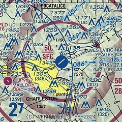
| Sectional chart |
|---|
|
CAUTION: Diagram may not be current
 Download PDF
of official airport diagram from the FAA
| Airport distance calculator |
|---|
|
|
| Sunrise and sunset |
|---|
|
Times for 26-May-2026
| | Local
(UTC-4) | | Zulu
(UTC) |
|---|
| Morning civil twilight | | 05:38 | | 09:38 |
| Sunrise | | 06:08 | | 10:08 |
| Sunset | | 20:39 | | 00:39 |
| Evening civil twilight | | 21:09 | | 01:09 |
|
| Current date and time |
|---|
| Zulu (UTC) | 26-May-2026 14:51:16 |
|---|
| Local (UTC-4) | 26-May-2026 10:51:16 |
|---|
|
| METAR |
|---|
| KCRW | 261354Z 18005KT 7SM -RA FEW005 SCT055 OVC095 21/21 A3013 RMK AO2 RAB09 SLP195 P0002 T02110206
|
|
| TAF |
|---|
| KCRW | 261321Z 2613/2712 00000KT 1SM -RA BR BKN004 OVC050 FM261400 00000KT 4SM -RA BR SCT005 OVC040 FM261600 VRB04KT P6SM VCSH BKN020 TEMPO 2616/2620 4SM -SHRA BKN015 FM262000 VRB04KT P6SM BKN045
|
|
| NOTAMs |
|---|
NOTAMs are issued by the DoD/FAA and will open in a separate window not controlled by AirNav.
|
|


