FAA INFORMATION EFFECTIVE 11 JUNE 2026
Location
| FAA Identifier: | 6S0 |
| Lat/Long: | 45-48-23.3181N 109-58-41.7237W
45-48.388635N 109-58.695395W
45.8064773,-109.9782566
(estimated) |
| Elevation: | 4493.9 ft. / 1369.7 m (surveyed) |
| Variation: | 11E (2020) |
| From city: | 3 miles SW of BIG TIMBER, MT |
| Time zone: | UTC -6 (UTC -7 during Standard Time) |
| Zip code: | 59011 |
Airport Operations
| Airport use: | Open to the public |
| Activation date: | 05/1941 |
| Control tower: | no |
| ARTCC: | SALT LAKE CITY CENTER |
| FSS: | GREAT FALLS FLIGHT SERVICE STATION |
| NOTAMs facility: | GTF (NOTAM-D service available) |
| Attendance: | MON-FRI 0800-1700, ALL SAT-SUN ON CALL
FOR ATTENDANT SAT & SUN CALL 406-932-4389. |
| Wind indicator: | lighted |
| Segmented circle: | yes |
| Lights: | PAPI RWY 24; MIRL RWY 06/24 OPR DUSK-MIDNIGHT, OTR TIMES ACTVT - CTAF. |
| Beacon: | white-green (lighted land airport)
Operates sunset to sunrise. |
Airport Communications
| CTAF/UNICOM: | 122.8 |
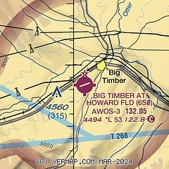
| WX AWOS-3: | 132.050 (406-932-6051) |
- APCH/DEP CTL SVC PRVDD BY SALT LAKE ARTCC (ZLC) ON 127.75/351.9 (BILLINGS RCAG).
Nearby radio navigation aids
| VOR radial/distance | | VOR name | | Freq | | Var |
|---|
| LVMr057/20.4 | | LIVINGSTON VOR/DME | | 116.10 | | 15E |
Airport Services
| Fuel available: | 100LL JET-A
100LL:100LL & JET A FUEL AVBL UPON REQ. CALL 406-932-4389 OR 406-930-1683. |
| Parking: | tiedowns |
| Airframe service: | MAJOR |
| Powerplant service: | MAJOR |
| Bottled oxygen: | NONE |
| Bulk oxygen: | NONE |
Runway Information
Runway 6/24
| Dimensions: | 5285 x 75 ft. / 1611 x 23 m |
| Surface: | asphalt, in good condition |
| Weight bearing capacity: | |
| Runway edge lights: | medium intensity |
| RUNWAY 6 | | RUNWAY 24 |
| Latitude: | 45-48.303167N | | 45-48.542020N |
| Longitude: | 109-59.242333W | | 109-58.046667W |
| Elevation: | 4490.2 ft. | | 4457.7 ft. |
| Traffic pattern: | left | | left |
| Runway heading: | 063 magnetic, 074 true | | 243 magnetic, 254 true |
| Markings: | nonprecision, in good condition | | nonprecision, in good condition |
| Visual slope indicator: | | | 2-light PAPI on left (3.00 degrees glide path) |
| Touchdown point: | yes, no lights | | yes, no lights |
Runway 18/36
| Dimensions: | 3475 x 75 ft. / 1059 x 23 m |
| Surface: | turf, in good condition |
| Runway edge markings: | 18/36 - THLDS MARKED WITH CONES. |
| RUNWAY 18 | | RUNWAY 36 |
| Latitude: | 45-48.614833N | | 45-48.059167N |
| Longitude: | 109-58.672833W | | 109-58.864500W |
| Elevation: | 4468.8 ft. | | 4492.4 ft. |
| Traffic pattern: | left | | left |
| Runway heading: | 182 magnetic, 193 true | | 002 magnetic, 013 true |
| Touchdown point: | yes, no lights | | yes, no lights |
Airport Ownership and Management from official FAA records
| Ownership: | Publicly-owned |
| Owner: | CITY OF BIG TIMBER/SWEETGRASS CO
PO BOX 888
BIG TIMBER, MT 59011
Phone 406-932-5152 |
| Manager: | KIRK BRYAN
BOX 279
BIG TIMBER, MT 59011
Phone 406-930-1780 |
Additional Remarks
| - | FOR CD CTC SALT LAKE ARTCC AT 801-320-2568. |
Instrument Procedures
NOTE: All procedures below are presented as PDF files. If you need a reader for these files, you should download the free Adobe Reader.NOT FOR NAVIGATION. Please procure official charts for flight.
FAA instrument procedures published for use from 11 June 2026 at 0901Z to 09 July 2026 at 0900z.
IAPs - Instrument Approach Procedures |
|---|
| RNAV (GPS) RWY 06 | |
download (348KB) |
| RNAV (GPS) RWY 24 | |
download (235KB) |
| NOTE: Special Alternate Minimums apply | |
download (208KB) |
| NOTE: Special Take-Off Minimums/Departure Procedures apply | |
download (540KB) |
Other nearby airports with instrument procedures:
KLVM - Mission Field Airport (21 nm W)
KHWQ - Wheatland County Airport at Harlowton (39 nm N)
KBZN - Bozeman Yellowstone International Airport (49 nm W)
6S8 - Laurel Municipal Airport (51 nm E)
7S6 - White Sulphur Springs Airport (57 nm NW)
|
|

Road maps at:
MapQuest
Bing
Google
| Aerial photo |
|---|
WARNING: Photo may not be current or correct
 Photo taken 24-Jun-2017
looking northeast.
Photo taken 24-Jun-2017
looking northeast.
Do you have a better or more recent aerial photo of Big Timber at Howard Field Airport that you would like to share? If so, please send us your photo.
|
| Sectional chart |
|---|
|
| Airport distance calculator |
|---|
|
|
| Sunrise and sunset |
|---|
|
Times for 12-Jun-2026
| | Local
(UTC-6) | | Zulu
(UTC) |
|---|
| Morning civil twilight | | 04:52 | | 10:52 |
| Sunrise | | 05:30 | | 11:30 |
| Sunset | | 21:09 | | 03:09 |
| Evening civil twilight | | 21:47 | | 03:47 |
|
| Current date and time |
|---|
| Zulu (UTC) | 12-Jun-2026 11:14:41 |
|---|
| Local (UTC-6) | 12-Jun-2026 05:14:41 |
|---|
|
| METAR |
|---|
| K6S0 | 121055Z AUTO 00000KT 10SM BKN100 10/02 A3004 RMK A01
|
|
| TAF |
|---|
KLVM
20nm W | 120534Z 1206/1306 32008KT P6SM FEW100 FM121700 27015G22KT P6SM FEW080 FM122000 29015KT P6SM SCT060 BKN120 PROB30 1221/1303 32015G30KT 4SM -SHRA SCT040 BKN060 FM130300 04011KT P6SM VCSH SCT060 BKN200
|
|
| NOTAMs |
|---|
NOTAMs are issued by the DoD/FAA and will open in a separate window not controlled by AirNav.
|
|


