FAA INFORMATION EFFECTIVE 14 MAY 2026
Location
| FAA Identifier: | 79J |
| Lat/Long: | 31-18-30.1000N 086-23-32.0000W
31-18.501667N 086-23.533333W
31.3083611,-86.3922222
(estimated) |
| Elevation: | 310.2 ft. / 94.5 m (surveyed) |
| Variation: | 02W (2005) |
| From city: | 4 miles E of ANDALUSIA, AL |
| Time zone: | UTC -5 (UTC -6 during Standard Time) |
| Zip code: | 36420 |
Airport Operations
| Airport use: | Open to the public |
| Activation date: | 04/1940 |
| Control tower: | no |
| ARTCC: | JACKSONVILLE CENTER |
| FSS: | ANNISTON FLIGHT SERVICE STATION |
| NOTAMs facility: | 79J (NOTAM-D service available) |
| Attendance: | SAT-SUN 0730-1630, ALL MON - FRI 0630-0000
AFT HRS SVC CALL 334-222-0638/334-427-0733 |
| Wind indicator: | lighted |
| Segmented circle: | yes |
| Lights: | ACTVT PAPI RWY 11 & 29; MIRL RWY 11/29 - CTAF. |
| Beacon: | white-green (lighted land airport)
Operates sunset to sunrise. |
Airport Communications
| CTAF/UNICOM: | 123.05 |
| WX ASOS: | 134.875 (334-222-9770) |
| CAIRNS APPROACH: | 133.45 |
| CAIRNS DEPARTURE: | 133.45 |
| WX ASOS at 0J4 (16 nm S): | 124.175 (251-216-1056) |
- APCH/DEP SVC PRVDD BY JACKSONVILLE ARTCC ON FREQS 134.3/322.55 (DOTHAN RCAG) WHEN CAIRNS APCH/DEP CLSD.
Nearby radio navigation aids
| VOR radial/distance | | VOR name | | Freq | | Var |
|---|
| EDNr275/(25.1) | | ENTERPRISE VOR | | 116.60 | | 03W |
| CEWr024/32.5 | | CRESTVIEW VORTAC | | 115.90 | | 03E |
| OZRr277/34.2 | | CAIRNS VOR/DME | | 111.20 | | 03W |
| HEYr267/(38.1) | | HANCHEY VOR | | 110.60 | | 03W |
| NDB name | | Hdg/Dist | | Freq | | Var | | ID |
|---|
| BOLL WEEVIL | | 268/21.1 | | 352 | | 03W | | BVG | -... ...- --. |
| BLOOD | | 209/34.6 | | 365 | | 04W | | TOI | - --- .. |
Airport Services
| Fuel available: | 100LL JET-A+
100LL:100LL SELF SERVE AVBL 24 HRS.
A+:MILITARY CONTRACT FUEL AVBL MON-FRI 0700-2400, OTHER TIMES CALL (334) 222-0638 |
| Parking: | tiedowns |
| Airframe service: | MAJOR |
| Powerplant service: | MAJOR |
| Bottled oxygen: | NONE |
| Bulk oxygen: | NONE |
Runway Information
Runway 11/29
| Dimensions: | 6000 x 100 ft. / 1829 x 30 m |
| Surface: | asphalt, in good condition |
| Weight bearing capacity: | | Single wheel: | 98.0 | | Double wheel: | 160.0 | | Double tandem: | 275.0 |
|
| Runway edge lights: | medium intensity |
| Runway edge markings: | MARKINGS FAIR DUE TO FADING |
| RUNWAY 11 | | RUNWAY 29 |
| Latitude: | 31-18.642895N | | 31-18.359393N |
| Longitude: | 086-24.085857W | | 086-22.981555W |
| Elevation: | 309.9 ft. | | 299.9 ft. |
| Traffic pattern: | left | | left |
| Runway heading: | 109 magnetic, 107 true | | 289 magnetic, 287 true |
| Markings: | nonprecision, in fair condition | | nonprecision, in good condition |
| Visual slope indicator: | 4-light PAPI on right (3.00 degrees glide path) | | 4-light PAPI on left (3.50 degrees glide path) |
| Runway end identifier lights: | yes | | yes |
| Touchdown point: | yes, no lights | | yes, no lights |
| Obstructions: | 102 ft. tree, 2795 ft. from runway, 100 ft. right of centerline, 25:1 slope to clear | | 54 ft. tree, 1535 ft. from runway, 176 ft. left of centerline, 24:1 slope to clear |
Airport Ownership and Management from official FAA records
| Ownership: | Publicly-owned |
| Owner: | ANDALUSIA ARPT AUTH
21861 BILL BENTON LANE
ANDALUSIA, AL 36421
Phone 334-222-6598 |
| Manager: | JED BLACKWELL
21861 BILL BENTON LANE
ANDALUSIA, AL 36421
Phone 334-222-6598
JED BLACKWELL |
Additional Remarks
| - | FOR CD CTC CAIRNS APCH AT 334-255-8402, WHEN APCH CLSD CTC JACKSONVILLE ARTCC AT 904-845-1592. |
Instrument Procedures
NOTE: All procedures below are presented as PDF files. If you need a reader for these files, you should download the free Adobe Reader.NOT FOR NAVIGATION. Please procure official charts for flight.
FAA instrument procedures published for use from 14 May 2026 at 0901Z to 11 June 2026 at 0900Z.
IAPs - Instrument Approach Procedures |
|---|
| RNAV (GPS) RWY 11 | |
download (245KB) |
| RNAV (GPS) RWY 29 | |
download (256KB) |
| NOTE: Special Alternate Minimums apply | |
download (159KB) |
| NOTE: Special Take-Off Minimums/Departure Procedures apply | |
download (480KB) |
Other nearby airports with instrument procedures:
0J4 - Florala Municipal Airport (16 nm S)
KEDN - Enterprise Municipal Airport (25 nm E)
KSXS - Shell Army Heliport (28 nm E)
33J - Geneva Municipal Airport (31 nm SE)
KCEW - Bob Sikes Airport (32 nm S)
|
|

Road maps at:
MapQuest
Bing
Google
| Aerial photo |
|---|
WARNING: Photo may not be current or correct
 Photo courtesy of AirNav, LLC
Photo taken 05-May-2011
looking southeast.
Photo courtesy of AirNav, LLC
Photo taken 05-May-2011
looking southeast.
Do you have a better or more recent aerial photo of South Alabama Regional Airport at Bill Benton Field that you would like to share? If so, please send us your photo.
|
| Sectional chart |
|---|
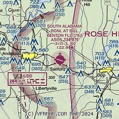
|
CAUTION: Diagram may not be current

| Airport distance calculator |
|---|
|
|
| Sunrise and sunset |
|---|
|
Times for 27-May-2026
| | Local
(UTC-5) | | Zulu
(UTC) |
|---|
| Morning civil twilight | | 05:17 | | 10:17 |
| Sunrise | | 05:44 | | 10:44 |
| Sunset | | 19:41 | | 00:41 |
| Evening civil twilight | | 20:08 | | 01:08 |
|
| Current date and time |
|---|
| Zulu (UTC) | 27-May-2026 15:24:50 |
|---|
| Local (UTC-5) | 27-May-2026 10:24:50 |
|---|
|
| METAR |
|---|
| K79J | 271456Z AUTO 12005KT 10SM BKN012 BKN021 26/24 A3004 RMK AO2 SLP169 60001 T02610239 53007 TSNO
|
K0J4
16nm S | 271502Z AUTO 17005KT 10SM BKN012 25/24 A3007 RMK AO2 T02500239
|
|
| TAF |
|---|
KOZR
35nm E | 271000Z 2710/2816 13005KT 9999 VCSH FEW007 BKN012 BKN200 QNH2998INS TEMPO 2711/2714 4800 BR SCT004 BKN007 BECMG 2714/2715 15008KT 9999 VCSH FEW010 SCT015 BKN025 BKN200 QNH3000INS BECMG 2717/2718 18008KT 9999 VCTS SCT025CB BKN050 BKN120 QNH2995INS TEMPO 2719/2723 VRB15G25KT 1600 +TSRA SCT007 OVC015CB BECMG 2801/2802 VRB06KT 9999 VCSH SCT005 BKN012 QNH3000INS TEMPO 2806/2810 BKN005 OVC012 TX28/2720Z TN22/2711Z
|
|
| NOTAMs |
|---|
NOTAMs are issued by the DoD/FAA and will open in a separate window not controlled by AirNav.
|
|


