FAA INFORMATION EFFECTIVE 14 MAY 2026
Location
| FAA Identifier: | 7A8 |
| Lat/Long: | 35-56-43.3000N 081-59-46.4000W
35-56.721667N 081-59.773333W
35.9453611,-81.9962222
(estimated) |
| Elevation: | 2745.2 ft. / 836.7 m (surveyed) |
| Variation: | 06W (2005) |
| From city: | 4 miles NE of SPRUCE PINE, NC |
| Time zone: | UTC -4 (UTC -5 during Standard Time) |
| Zip code: | 28777 |
Airport Operations
| Airport use: | Open to the public |
| Activation date: | 11/1962 |
| Control tower: | no |
| ARTCC: | ATLANTA CENTER |
| FSS: | RALEIGH FLIGHT SERVICE STATION |
| NOTAMs facility: | RDU (NOTAM-D service available) |
| Attendance: | UNATTENDED |
| Wind indicator: | lighted |
| Segmented circle: | no |
Airport Communications
- AUTOMATED UNICOM.
- APCH/DEP SVC PRVDD BY ATLANTA ARTCC (ZTL) ON 125.15/263.0 (HICKORY RCAG).
Nearby radio navigation aids
| VOR radial/distance | | VOR name | | Freq | | Var |
|---|
| HMVr172/30.2 | | HOLSTON MOUNTAIN VORTAC | | 114.60 | | 04W |
| SUGr024/35.0 | | SUGARLOAF MOUNTAIN VORTAC | | 112.20 | | 02W |
| BZMr283/37.0 | | BARRETTS MOUNTAIN VOR/DME | | 113.75 | | 06W |
| NDB name | | Hdg/Dist | | Freq | | Var | | ID |
|---|
| HEMLOCK | | 206/13.7 | | 320 | | 02W | | BAR | -... .- .-. |
| FIDDLERS | | 319/21.2 | | 391 | | 07W | | FIQ | ..-. .. --.- |
Airport Services
| Fuel available: | 100LL JET-A1+
100LL:24 HR 100LL & JET A FUEL SVC AVBL WITH CREDIT CARD. |
| Parking: | tiedowns |
| Airframe service: | NONE |
| Powerplant service: | NONE |
| Bottled oxygen: | NONE |
| Bulk oxygen: | NONE |
Runway Information
Runway 17/35
| Dimensions: | 3001 x 60 ft. / 915 x 18 m |
| Surface: | asphalt, in excellent condition |
| Weight bearing capacity: | |
| Operational restrictions: | RWY 17/35 RWY 17 PREFERRED FOR TKOFS - RWY 35 PREFERRED FOR LDGS. |
| RUNWAY 17 | | RUNWAY 35 |
| Latitude: | 35-56.953142N | | 35-56.489433N |
| Longitude: | 081-59.879532W | | 081-59.668443W |
| Elevation: | 2745.2 ft. | | 2700.6 ft. |
| Traffic pattern: | right | | left |
| Runway heading: | 166 magnetic, 160 true | | 346 magnetic, 340 true |
| Markings: | basic, in good condition | | basic, in good condition |
| Touchdown point: | yes, no lights | | yes, no lights |
| Obstructions: | 14 ft. brush, 219 ft. from runway, 20 ft. right of centerline, 1:1 slope to clear
HAS 17 FT TREES 0-200 FT FR THR OFFSET 118 FT LEFT OF CNTRLN. | | 3 ft. brush, 204 ft. from runway, 62 ft. right of centerline, 1:1 slope to clear
HAS 4 FT BRUSH 189 FT FR THR OFFSET 121 FT LEFT OF CNTRLN. |
Helipad H1
| Dimensions: | 40 x 40 ft. / 12 x 12 m |
| Surface: | concrete, in good condition |
| Runway edge lights: | PERI |
| Latitude: | 35-56.890000N | | |
| Longitude: | 081-59.810000W | | |
| Elevation: | 2750.0 ft. | | |
| Traffic pattern: | left | | left |
| Markings: | basic, in good condition | | |
| Obstructions: | 60 ft. trees, 462 ft. from runway, 10 ft. right of centerline, 7:1 slope to clear | | |
Airport Ownership and Management from official FAA records
| Ownership: | Publicly-owned |
| Owner: | AVERY COUNTY ARPT AUTHORITY
P O BOX 927
NEWLAND, NC 28657
Phone 828-260-3668 |
| Manager: | DEAN HARRIS
400 BRUSHY CREEK ROAD
SPRUCE PINE, NC 28777
Phone 828-260-3668 |
Additional Remarks
| - | VFR OPS ONLY. |
| - | HIGH TRRN ALL QUADS, DALGT VFR OPS ONLY, RWY 35 UPHILL GRADE, RWY 17 RGT TFC PREFERRED FOR TKOF. |
| - | MIL OPS ON AND INVOF ARPT. |
| - | WILDLIFE ON AND INVOF ARPT. |
| - | GRAVEL MINING OPS WEST OF AND ADJ TO RWY WITH DIRT BANK RANGING 26-48 FT HIGH LCTD 300-500 FT FROM RWY CNTRLN. |
| - | RWY 35 HAS 220+ FT TREES AND MTUS TRRN 2200FT FM THLD OFFSET 400 FT RIGHT OF CNTRLN. |
| - | FOR CD CTC ATLANTA ARTCC AT 770-210-7692. |
| - | ONGOING CONST ACT WITH MEN AND EQUIP ON AND INVOF RWY 17/35. |
| - | GRASS LDG AREA FOR JAARS TRNG ONLY; SIMUL LDGS ON GRASS AND ON RWY PROHIBITED. |
| - | RWY 35 MTUS TRRN 6000 FT FM RWY END AND 650 FT ABV RWY ELEV ON CNTRLN. |
| - | RWY 35 HAS 60 FT DROP-OFF 250 FT FROM THR AND 50 RIGHT OF CNTRLN. RWY 17 HAS 40 FT DROP-OFF 300 FT FROM THR. |
Instrument Procedures
There are no published instrument procedures at 7A8.
Some nearby airports with instrument procedures:
KMRN - Foothills Regional Airport (20 nm E)
0A9 - William B Greene Jr Regional Airport (27 nm N)
6A4 - Johnson County Airport (30 nm N)
KFQD - Rutherford County Airport/Marchman Field (31 nm S)
KHKY - Hickory Regional Airport (32 nm E)
|
|

Road maps at:
MapQuest
Bing
Google
| Aerial photo |
|---|
WARNING: Photo may not be current or correct
 Photo by Max Grogan
Photo taken 25-Oct-2009
looking northwest.
Photo by Max Grogan
Photo taken 25-Oct-2009
looking northwest.
Do you have a better or more recent aerial photo of Avery County Airport/Morrison Field that you would like to share? If so, please send us your photo.
|
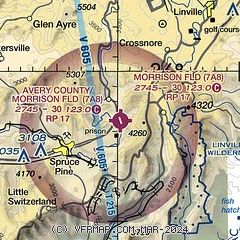
| Sectional chart |
|---|
|
| Airport distance calculator |
|---|
|
|
| Sunrise and sunset |
|---|
|
Times for 07-Jun-2026
| | Local
(UTC-4) | | Zulu
(UTC) |
|---|
| Morning civil twilight | | 05:42 | | 09:42 |
| Sunrise | | 06:12 | | 10:12 |
| Sunset | | 20:41 | | 00:41 |
| Evening civil twilight | | 21:11 | | 01:11 |
|
| Current date and time |
|---|
| Zulu (UTC) | 07-Jun-2026 10:21:27 |
|---|
| Local (UTC-4) | 07-Jun-2026 06:21:27 |
|---|
|
| TAF |
|---|
KHKY
32nm E | 070530Z 0706/0806 18003KT P6SM BKN250 FM071600 24006KT P6SM SCT060 BKN250 FM080100 VRB03KT P6SM BKN250
|
KTRI
38nm NW | 070524Z 0706/0806 VRB03KT P6SM BKN250 FM071600 26007KT P6SM SCT070
|
|
| NOTAMs |
|---|
NOTAMs are issued by the DoD/FAA and will open in a separate window not controlled by AirNav.
|
|

