FAA INFORMATION EFFECTIVE 19 MARCH 2026
Location
| FAA Identifier: | 7B2 |
| Lat/Long: | 42-19-40.8350N 072-36-40.4650W
42-19.680583N 072-36.674417W
42.3280097,-72.6112403
(estimated) |
| Elevation: | 121.4 ft. / 37.0 m (surveyed) |
| Variation: | 15W (1990) |
| From city: | 1 mile NE of NORTHAMPTON, MA |
| Time zone: | UTC -4 (UTC -5 during Standard Time) |
| Zip code: | 01060 |
Airport Operations
| Airport use: | Open to the public |
| Activation date: | 04/1940 |
| Control tower: | no |
| ARTCC: | BOSTON CENTER |
| FSS: | BURLINGTON FLIGHT SERVICE STATION |
| NOTAMs facility: | BTV (NOTAM-D service available) |
| Attendance: | 0800-1800 |
| Wind indicator: | lighted |
| Segmented circle: | no |
| Lights: | ACTVT MIRL RWY 14/32 - CTAF. |
| Beacon: | white-green (lighted land airport)
Operates sunset to sunrise. |
Airport Communications
| CTAF/UNICOM: | 122.7 |
| BRADLEY APPROACH: | 125.35 |
| BRADLEY DEPARTURE: | 125.35 |
| CLEARANCE DELIVERY: | 133.6 |
| WX ASOS at BAF (11 nm SW): | 127.1 (413-568-2267) |
Nearby radio navigation aids
| VOR radial/distance | | VOR name | | Freq | | Var |
|---|
| BAFr039/11.0 | | BARNES VORTAC | | 113.00 | | 14W |
| CTRr095/15.2 | | CHESTER VOR/DME | | 115.10 | | 13W |
| GDMr256/27.8 | | GARDNER VOR/DME | | 116.95 | | 14W |
Airport Services
| Fuel available: | 100LL
100LL:FUEL IS 24 HR SELF-SERVE. |
| Parking: | hangars and tiedowns |
| Airframe service: | MAJOR |
| Powerplant service: | MAJOR |
| Bottled oxygen: | NONE |
| Bulk oxygen: | NONE |
Runway Information
Runway 14/32
| Dimensions: | 3335 x 50 ft. / 1017 x 15 m |
| Surface: | asphalt, in good condition |
| Weight bearing capacity: | |
| Runway edge lights: | medium intensity |
| RUNWAY 14 | | RUNWAY 32 |
| Latitude: | 42-19.848167N | | 42-19.513000N |
| Longitude: | 072-36.967500W | | 072-36.381333W |
| Elevation: | 121.4 ft. | | 118.8 ft. |
| Traffic pattern: | left | | left |
| Runway heading: | 143 magnetic, 128 true | | 323 magnetic, 308 true |
| Displaced threshold: | no | | 220 ft. |
| Markings: | basic, in good condition | | basic, in good condition |
| Visual slope indicator: | 4-light PAPI on left (4.50 degrees glide path) | | |
| Runway end identifier lights: | no | | no |
| Touchdown point: | yes, no lights | | yes, no lights |
| Obstructions: | 60 ft. trees, 600 ft. from runway, 210 ft. right of centerline, 6:1 slope to clear
15 FT ROAD IN PRIM SFC. | | 32 ft. trees, 1000 ft. from runway, 51 ft. right of centerline, 25:1 slope to clear
ROAD IN PRIM SFC 50 FT FM THR. |
Airport Ownership and Management from official FAA records
| Ownership: | Privately-owned |
| Owner: | SEVEN BRAVO TWO, LLC
160 OLD FERRY RD
NORTHAMPTON, MA 01060
Phone 413-568-0905 |
| Manager: | RICHARD MACISAAC
160 OLD FERRY RD
NORTHAMPTON, MA 01060
Phone 860-833-7602
RICHM@FLY7B2.COM |
Additional Remarks
| - | ARPT CLSD TO ALL ACFT & HEL CRTFYD FOR 12500 LBS & OVR. |
| - | LDG FEE FOR COML ACFT. |
| - | FEE & PPR FOR COML BLN OPS. |
| - | FOR CD CTC BRADLEY APCH AT 860-386-3597. |
| - | GLDR ACT ON & INVOF ARPT MAY-OCT. |
| - | COLD TEMPERATURE AIRPORT. ALTITUDE CORRECTION REQUIRED AT OR BELOW -24C. |
| - | (PAY PHONE) PAY PHONE AVAILABLE. |
Instrument Procedures
NOTE: All procedures below are presented as PDF files. If you need a reader for these files, you should download the free Adobe Reader.NOT FOR NAVIGATION. Please procure official charts for flight.
FAA instrument procedures published for use from 19 March 2026 at 0901Z to 16 April 2026 at 0900Z.
IAPs - Instrument Approach Procedures |
|---|
| RNAV (GPS) RWY 14 | |
download (257KB) |
| VOR/DME-B | |
download (176KB) |
| NOTE: Special Take-Off Minimums/Departure Procedures apply | |
download (178KB) |
Other nearby airports with instrument procedures:
KCEF - Westover Air Reserve Base/Metropolitan Airport (9 nm SE)
KBAF - Westfield-Barnes Regional Airport (11 nm SW)
0B5 - Turners Falls Airport (16 nm N)
KORE - Orange Municipal Airport (20 nm NE)
KBDL - Bradley International Airport (24 nm S)
|
|

Road maps at:
MapQuest
Bing
Google
| Aerial photo |
|---|
WARNING: Photo may not be current or correct
 Photo by Ryan Wilkinson
Photo taken 22-Jul-2017
looking northwest.
Photo by Ryan Wilkinson
Photo taken 22-Jul-2017
looking northwest.
Do you have a better or more recent aerial photo of Northampton Airport that you would like to share? If so, please send us your photo.
|
| Sectional chart |
|---|
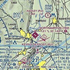
|
| Airport distance calculator |
|---|
|
|
| Sunrise and sunset |
|---|
|
Times for 06-Apr-2026
| | Local
(UTC-4) | | Zulu
(UTC) |
|---|
| Morning civil twilight | | 05:57 | | 09:57 |
| Sunrise | | 06:25 | | 10:25 |
| Sunset | | 19:20 | | 23:20 |
| Evening civil twilight | | 19:49 | | 23:49 |
|
| Current date and time |
|---|
| Zulu (UTC) | 06-Apr-2026 10:49:22 |
|---|
| Local (UTC-4) | 06-Apr-2026 06:49:22 |
|---|
|
| METAR |
|---|
KCEF
9nm SE | 060955Z AUTO 31015G20KT 10SM OVC041 04/M05 A2988 RMK AO2 SLP123 T00401047
|
KBAF
11nm SW | 060953Z AUTO 30008G21KT 10SM OVC045 03/M04 A2991 RMK AO2 SLP131 T00331044
|
|
| TAF |
|---|
KCEF
9nm SE | 060100Z 0600/0706 33010G15KT 9999 FEW035 BKN060 520055 QNH2977INS BECMG 0602/0603 30012G18KT 9999 FEW040 BKN080 520055 QNH2982INS TEMPO 0608/0613 30015G25KT 520006 TEMPO 0613/0623 30015G30KT 520006 BECMG 0700/0700 30006KT 9999 BKN080 520055 QNH3001INS TX11/0620Z TN01/0611Z LAST NO AMDS AFT 0601 NEXT 0613
|
KBAF
11nm SW | 060400Z 0604/0710 28010G15KT 9999 SCT030 OVC040 620402 530406 QNH2984INS BECMG 0613/0614 29012G25KT 9999 FEW050 530604 QNH2995INS BECMG 0622/0623 VRB06KT 9999 BKN040 620404 QNH3002INS TX08/0618Z TN02/0611Z
|
|
| NOTAMs |
|---|
NOTAMs are issued by the DoD/FAA and will open in a separate window not controlled by AirNav.
|
|

