FAA INFORMATION EFFECTIVE 09 JULY 2026
Location
| FAA Identifier: | 0B5 |
| Lat/Long: | 42-35-29.8000N 072-31-22.8000W
42-35.496667N 072-31.380000W
42.5916111,-72.5230000
(estimated) |
| Elevation: | 358.7 ft. / 109.3 m (surveyed) |
| Variation: | 15W (1995) |
| From city: | 3 miles N of MONTAGUE, MA |
| Time zone: | UTC -4 (UTC -5 during Standard Time) |
| Zip code: | 01376 |
Airport Operations
| Airport use: | Open to the public |
| Activation date: | 02/1940 |
| Control tower: | no |
| ARTCC: | BOSTON CENTER |
| FSS: | BURLINGTON FLIGHT SERVICE STATION |
| NOTAMs facility: | BTV (NOTAM-D service available) |
| Attendance: | MON-FRI 0800-1600 |
| Wind indicator: | yes |
| Segmented circle: | no |
| Lights: | ACTVT REIL RWY 16; MIRL RWY 16/34 - CTAF. |
| Beacon: | white-green (lighted land airport)
Operates sunset to sunrise. |
Airport Communications
| CTAF/UNICOM: | 123.0 |
| WX ASOS at ORE (10 nm E): | 135.675 (978-544-6774) |
- APCH/DEP SVC PRVDD BY BOSTON ARTCC ON FREQS 123.75/338.2 (GARDNER RCAG).
Nearby radio navigation aids
| VOR radial/distance | | VOR name | | Freq | | Var |
|---|
| GDMr292/20.7 | | GARDNER VOR/DME | | 116.95 | | 14W |
| CTRr059/26.1 | | CHESTER VOR/DME | | 115.10 | | 13W |
| BAFr032/27.2 | | BARNES VORTAC | | 113.00 | | 14W |
Airport Services
| Fuel available: | 100LL JET-A1
A1:FUEL CART CTC AMGR. |
| Parking: | hangars and tiedowns |
| Airframe service: | MAJOR |
| Powerplant service: | MAJOR |
| Bottled oxygen: | NONE |
| Bulk oxygen: | NONE |
Runway Information
Runway 16/34
| Dimensions: | 3200 x 75 ft. / 975 x 23 m |
| Surface: | asphalt, in excellent condition |
| Weight bearing capacity: | |
| Runway edge lights: | medium intensity |
| RUNWAY 16 | | RUNWAY 34 |
| Latitude: | 42-35.706193N | | 42-35.287208N |
| Longitude: | 072-31.596093W | | 072-31.163990W |
| Elevation: | 352.7 ft. | | 358.7 ft. |
| Traffic pattern: | left | | left |
| Runway heading: | 158 magnetic, 143 true | | 338 magnetic, 323 true |
| Displaced threshold: | no | | 550 ft. |
| Markings: | basic, in good condition | | basic, in good condition |
| Visual slope indicator: | 4-light PAPI on left (3.00 degrees glide path) | | |
| Runway end identifier lights: | yes | | no |
| Touchdown point: | yes, no lights | | yes, no lights |
| Obstructions: | 20 ft. trees, 600 ft. from runway, 130 ft. left of centerline, 20:1 slope to clear | | 30 ft. trees, 800 ft. from runway, 150 ft. right of centerline, 20:1 slope to clear |
Airport Ownership and Management from official FAA records
| Ownership: | Publicly-owned |
| Owner: | TOWN OF MONTAGUE
1 AVENUE A
TURNERS FALLS, MA 01376
Phone 413-863-0044 |
| Manager: | BRYAN CAMDEN
C/O TOWN OF MONTAGUE, 1 AVENUE A
TURNERS FALLS, MA 01376
Phone 413-863-0044
AMGR CTC 24 HRS CELL 978-305-2452. |
Additional Remarks
| - | RWY 16 IS CALM WIND RWY. |
| - | WILDLIFE & BIRDS INVOF ARPT. |
| - | FOR CD CTC BOSTON ARTCC AT 603-879-6859. |
| - | COLD TEMPERATURE AIRPORT. ALTITUDE CORRECTION REQUIRED AT OR BELOW -25C. |
Instrument Procedures
NOTE: All procedures below are presented as PDF files. If you need a reader for these files, you should download the free Adobe Reader.NOT FOR NAVIGATION. Please procure official charts for flight.
FAA instrument procedures published for use from 09 July 2026 at 0901Z to 06 August 2026 at 0900Z.
IAPs - Instrument Approach Procedures |
|---|
| RNAV (GPS)-B | |
download (211KB) |
| NOTE: Special Take-Off Minimums/Departure Procedures apply | |
download (388KB) |
Other nearby airports with instrument procedures:
KORE - Orange Municipal Airport (10 nm E)
7B2 - Northampton Airport (16 nm S)
KEEN - Dillant/Hopkins Airport (22 nm NE)
KGDM - Gardner Municipal Airport (23 nm E)
KCEF - Westover Air Reserve Base/Metropolitan Airport (24 nm S)
|
|

Road maps at:
MapQuest
Bing
Google
| Aerial photo |
|---|
WARNING: Photo may not be current or correct
 Photo taken 06-Mar-2006
Do you have a better or more recent aerial photo of Turners Falls Airport that you would like to share? If so, please send us your photo.
|
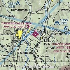
| Sectional chart |
|---|
|
CAUTION: Diagram may not be current

| Airport distance calculator |
|---|
|
|
| Sunrise and sunset |
|---|
|
Times for 02-Aug-2026
| | Local
(UTC-4) | | Zulu
(UTC) |
|---|
| Morning civil twilight | | 05:12 | | 09:12 |
| Sunrise | | 05:44 | | 09:44 |
| Sunset | | 20:09 | | 00:09 |
| Evening civil twilight | | 20:40 | | 00:40 |
|
| Current date and time |
|---|
| Zulu (UTC) | 02-Aug-2026 18:31:07 |
|---|
| Local (UTC-4) | 02-Aug-2026 14:31:07 |
|---|
|
| METAR |
|---|
KORE
11nm E | 021752Z AUTO 18015G20KT 10SM CLR 29/18 A2997 RMK AO2 SLP146 T02890183 10300 20228 56008
|
KEEN
21nm NE | 021756Z AUTO 19012KT 10SM FEW048 29/19 A2994 RMK AO2 SLP138 T02890194 10300 20217 57012
|
|
| TAF |
|---|
KCEF
23nm S | 021712Z 0217/0323 20009KT 9999 SCT035 BKN075 BKN150 QNH2987INS TEMPO 0217/0222 24010G25KT 510006 BECMG 0222/0223 18006KT 9999 SCT035 BKN060 BKN150 QNH2984INS BECMG 0304/0305 15009KT 6000 -RA BR SCT006 BKN024 OVC120 QNH2969INS TEMPO 0305/0310 3200 RA BR BKN005 OVC024 BECMG 0315/0316 21009KT 4800 -RA BR SCT006 BKN010 OVC020 520006 QNH2967INS TEMPO 0318/0323 24015G30KT 3200 -TSRA BKN006 BKN010CB OVC020 TX29/0221Z TN20/0310Z
|
KBAF
27nm S | 021200Z 0212/0318 18006KT 9999 SCT020 BKN040 QNH2995INS TEMPO 0212/0214 8000 BR OVC006 BECMG 0218/0219 18009KT 9999 BKN020 QNH2991INS BECMG 0307/0308 15012G18KT 8000 -SHRA OVC007 QNH2982INS TX29/0219Z TN20/0310Z
|
|
| NOTAMs |
|---|
NOTAMs are issued by the DoD/FAA and will open in a separate window not controlled by AirNav.
|
|


