FAA INFORMATION EFFECTIVE 16 APRIL 2026
Location
| FAA Identifier: | 85NK |
| Lat/Long: | 42-09-15.2200N 079-00-59.1500W
42-09.253667N 079-00.985833W
42.1542278,-79.0164306
(estimated) |
| Elevation: | 1666 ft. / 508 m (estimated) |
| Variation: | 09W (1985) |
| From city: | 2 miles W of RANDOLPH, NY |
| Time zone: | UTC -4 (UTC -5 during Standard Time) |
| Zip code: | 14772 |
Airport Operations
| Airport use: | Private use. Permission required prior to landing |
| Activation date: | 02/1961 |
| Control tower: | no |
| ARTCC: | CLEVELAND CENTER |
| FSS: | BUFFALO FLIGHT SERVICE STATION |
| Attendance: | IRREG |
| Wind indicator: | yes |
| Segmented circle: | no |
Airport Communications
| WX AWOS-3PT at JHW (11 nm W): | 118.425 (716-664-6005) |
Nearby radio navigation aids
| VOR radial/distance | | VOR name | | Freq | | Var |
|---|
| JHWr121/5.1 | | JAMESTOWN VOR/DME | | 114.70 | | 07W |
Airport Services
| Parking: | hangars |
| Airframe service: | NONE |
| Powerplant service: | NONE |
Runway Information
Runway 8/26
| Dimensions: | 2495 x 80 ft. / 760 x 24 m |
| Surface: | turf, in excellent condition |
| RUNWAY 8 | | RUNWAY 26 |
| Traffic pattern: | left | | left |
| Obstructions: | 8 ft. brush, 1 ft. from runway, 63 ft. right of centerline | | 3 ft. brush, 1 ft. from runway, 110 ft. left of centerline |
Airport Ownership and Management from official FAA records
| Ownership: | Privately-owned |
| Owner: | ROBERT AND ANITA CAMPBELL
4729 WHITESIDE PK WY
MAPLE SPRINGS, NY 14756
Phone 716-386-6538 |
| Manager: | ROBERT AND ANITA CAMPBELL
P. O. BOX 302
RANDOLPH, NY 14772 |
Additional Remarks
| - | DEER ON INVOF ARPT OCCASIONALLY AT DUSK AND EARLY MORNING. |
| - | +15 FT BRUSH ALONG SOUTH EDGE OF RY, 50-60 FT FM RY CTRLN. |
| - | RY 8 HAS +44 FT TREE, 20 FT FM RY END, 75 FT RIGHT OF CTRLN; +63 FT TREE, 135 FT FM RY END, 115 FT RIGHT OF CTRLN; +63 FT TREES, 520 FT FM RY END,125 FT RIGHT OF CTRLN. |
| - | RY 26 HAS +82 FT TREES, 760 FT FM RY END, ACROSS RY CTRLN. |
| - | LTD VSBY DOWN RY, CANNOT SEE ACFT ON RY END FROM OPPOSITE RY END. |
| - | FOR CD CTC BUFFALO APCH AT 716-626-6920, WHEN APCH CLSD CTC CLEVELAND ARTCC AT 440-774-0232. |
Instrument Procedures
There are no published instrument procedures at 85NK.
Some nearby airports with instrument procedures:
KJHW - Chautauqua County/Jamestown Airport (11 nm W)
KDKK - Chautauqua County/Dunkirk Airport (23 nm NW)
KBFD - Bradford Regional Airport (27 nm SE)
KOLE - Cattaraugus County-Olean Airport (29 nm E)
8G2 - Corry-Lawrence Airport (32 nm SW)
|
|

Road maps at:
MapQuest
Bing
Google
| Aerial photo |
|---|
WARNING: Photo may not be current or correct
 Photo by Robert Campbell
Taken in 2005
Photo by Robert Campbell
Taken in 2005
Do you have a better or more recent aerial photo of Campbell Field Airport that you would like to share? If so, please send us your photo.
|
| Sectional chart |
|---|
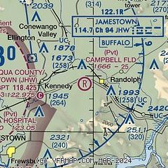
|
| Airport distance calculator |
|---|
|
|
| Sunrise and sunset |
|---|
|
Times for 05-May-2026
| | Local
(UTC-4) | | Zulu
(UTC) |
|---|
| Morning civil twilight | | 05:37 | | 09:37 |
| Sunrise | | 06:07 | | 10:07 |
| Sunset | | 20:18 | | 00:18 |
| Evening civil twilight | | 20:49 | | 00:49 |
|
| Current date and time |
|---|
| Zulu (UTC) | 05-May-2026 09:23:23 |
|---|
| Local (UTC-4) | 05-May-2026 05:23:23 |
|---|
|
| METAR |
|---|
KJHW
11nm W | 050856Z AUTO 22012G19KT 10SM BKN070 BKN090 16/10 A2965 RMK AO2 SLP038 60001 T01560100 56006
|
|
| TAF |
|---|
KJHW
11nm W | 050537Z 0506/0606 20012G20KT 6SM -SHRA BKN060 WS020/24045KT TEMPO 0506/0510 4SM -TSRA OVC025CB FM051000 22012G22KT P6SM BKN050 WS020/24045KT PROB30 0510/0514 4SM -SHRA OVC025 FM051500 24017G28KT P6SM BKN025 PROB30 0515/0518 4SM -SHRA OVC015 FM051800 28013G25KT 4SM SHRA OVC020 PROB30 0518/0522 2SM TSRA OVC007CB FM052200 31008KT 4SM SHRA OVC007 FM060300 VRB03KT 4SM RA OVC003
|
|
| NOTAMs |
|---|
NOTAMs are issued by the DoD/FAA and will open in a separate window not controlled by AirNav.
|
|

