FAA INFORMATION EFFECTIVE 14 MAY 2026
Location
| FAA Identifier: | 8W5 |
| Lat/Long: | 47-39-23.1550N 122-43-59.4450W
47-39.385917N 122-43.990750W
47.6564319,-122.7331792
(estimated) |
| Elevation: | 525 ft. / 160 m (estimated) |
| Variation: | 21E (1975) |
| From city: | 2 miles NW of SILVERDALE, WA |
| Time zone: | UTC -7 (UTC -8 during Standard Time) |
| Zip code: | 98383 |
Airport Operations
| Airport use: | Open to the public |
| Activation date: | 08/1947 |
| Control tower: | no |
| ARTCC: | SEATTLE CENTER |
| FSS: | SEATTLE FLIGHT SERVICE STATION |
| NOTAMs facility: | SEA (NOTAM-D service available) |
| Attendance: | 1000-1900 |
| Wind indicator: | yes |
| Segmented circle: | yes |
| Lights: | SS-SR |
| Beacon: | white-green (lighted land airport)
Operates sunset to sunrise. |
Airport Communications
| CTAF/UNICOM: | 122.8 |
| WX AWOS-3PT at PWT (10 nm S): | 121.2 (360-674-2811) |
| WX ASOS at BFI (19 nm SE): | PHONE 206-658-6435 |
Nearby radio navigation aids
| VOR radial/distance | | VOR name | | Freq | | Var |
|---|
| SEAr289/21.7 | | SEATTLE VORTAC | | 116.80 | | 19E |
| PAEr209/24.2 | | PAINE VOR/DME | | 110.60 | | 20E |
| CVVr162/35.3 | | PENN COVE VOR/DME | | 117.20 | | 19E |
Airport Services
| Parking: | tiedowns |
| Airframe service: | MAJOR |
| Powerplant service: | MAJOR |
| Bottled oxygen: | NONE |
| Bulk oxygen: | NONE |
Runway Information
Runway 17/35
| Dimensions: | 2491 x 28 ft. / 759 x 9 m |
| Surface: | asphalt, in fair condition |
| Runway edge lights: | low intensity |
| Runway edge markings: | ARPT NAME & SEGEMENTED CIRCLE PAINTED ON RWY AT MIDFIELD. |
| RUNWAY 17 | | RUNWAY 35 |
| Latitude: | 47-39.589000N | | 47-39.182833N |
| Longitude: | 122-43.950833W | | 122-44.030667W |
| Elevation: | 520.0 ft. | | 510.0 ft. |
| Traffic pattern: | left | | right |
| Markings: | basic, in fair condition | | basic, in fair condition |
| Runway end identifier lights: | no | | no |
| Touchdown point: | yes, no lights | | yes, no lights |
| Obstructions: | 65 ft. trees, 844 ft. from runway, 9:1 slope to clear
+3 FT FENCE, 26 FT RIGHT AT 60 FT; +60 FT TREES, 65 FT RIGHT AT 150 FT; 15 FT BRUSH, 67 FT LEFT AT 75 FT; BLDG AT 55 FT, 80 FT LEFT; 17 FT BLDG AT 77 FT, 72 FT RIGHT. | | 68 ft. trees, 1035 ft. from runway, 12:1 slope to clear
+4 FT SIGN 66 FT RIGHT AT 45 FT, +10 FT TO +70 FT BRUSH AND TREES 85-125 FT LEFT FM THR TO 200 FT. BRUSH AND TREES 105 FT RIGHT AT 174 FT FM THR. |
Airport Ownership and Management from official FAA records
| Ownership: | Privately-owned |
| Owner: | APEX PROPERTY OWNERS, INC.
PO BOX 1659
SILVERDALE, WA 98383
Phone 253-312-0902
ALT MGR BILL ROARK AT 206-390-4131. |
| Manager: | PAUL SCHNEIDER
PO BOX 1659, APEX PROPERTY OWNERS, PRESIDENT
SILVERDALE, WA 98383
Phone 816-810-3327
H2OAV8R@GMAIL.COM |
Additional Remarks
| - | TWY EAST SIDE RWY. |
| - | CALM WIND RWY IS RWY 35. |
| - | USE CTN FOR ACFT OPRG ON GRASS WEST OF RWY. |
| - | INT TKOF PROHIBITED. |
| - | TSNT PRKG BYD NORTH END RWY 35. |
| - | USE MID-FIELD RUN-UP PAD FOR ALL RUN-UPS. |
| - | CLIMB TO 1000 FT PRIOR TO TURNING FOR NOISE ABATEMENT. |
| - | NO LN OF SIGHT BTN RWY ENDS. TAX TO MID-FIELD RUN-UP AREA RQRD PRIOR TO TKOF TO CLR FOR OPDT. |
| - | TREES, ACFT AND BDLGS IN TRANSITION SFCS. |
| - | CHILDREN AND PETS ETC. INVOF ARPT. |
| - | BE ALERT ON TWY. |
| - | FOR CD CTC SEATTLE APCH AT 206-214-4722. |
| - | ALL TFC PATS EAST OF FLD. |
Instrument Procedures
There are no published instrument procedures at 8W5.
Some nearby airports with instrument procedures:
KPWT - Bremerton National Airport (10 nm S)
KBFI - Boeing Field/King County International Airport (19 nm SE)
KSEA - Seattle-Tacoma International Airport (21 nm SE)
KRNT - Renton Municipal Airport (23 nm SE)
KPAE - Seattle Paine Field International Airport (24 nm NE)
|
|

Road maps at:
MapQuest
Bing
Google
| Aerial photo |
|---|
WARNING: Photo may not be current or correct
 Photo courtesy of longbachnguyen.com
Photo taken 09-Apr-2010
Photo courtesy of longbachnguyen.com
Photo taken 09-Apr-2010
Do you have a better or more recent aerial photo of Apex Airpark that you would like to share? If so, please send us your photo.
|
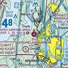
| Sectional chart |
|---|
|
| Airport distance calculator |
|---|
|
|
| Sunrise and sunset |
|---|
|
Times for 31-May-2026
| | Local
(UTC-7) | | Zulu
(UTC) |
|---|
| Morning civil twilight | | 04:39 | | 11:39 |
| Sunrise | | 05:19 | | 12:19 |
| Sunset | | 20:59 | | 03:59 |
| Evening civil twilight | | 21:38 | | 04:38 |
|
| Current date and time |
|---|
| Zulu (UTC) | 31-May-2026 20:58:44 |
|---|
| Local (UTC-7) | 31-May-2026 13:58:44 |
|---|
|
| METAR |
|---|
KPWT
9nm S | 311956Z AUTO VRB03KT 10SM CLR 17/07 A3031 RMK AO2 SLP269 T01720067
|
KBFI
18nm E | 312053Z 30010G17KT 10SM FEW070 19/03 A3030 RMK AO2 SLP259 T01890033 58015
|
|
| TAF |
|---|
KPWT
9nm S | 311720Z 3118/0118 00000KT P6SM SKC FM311900 04008KT P6SM SKC FM010300 03004KT P6SM SKC FM010600 VRB03KT P6SM SKC FM011600 05008KT P6SM SKC
|
KBFI
18nm E | 311720Z 3118/0118 08005KT P6SM FEW090 FM312000 32008KT P6SM SKC FM010400 VRB03KT P6SM SKC FM011000 00000KT P6SM SKC
|
|
| NOTAMs |
|---|
NOTAMs are issued by the DoD/FAA and will open in a separate window not controlled by AirNav.
|
|

