FAA INFORMATION EFFECTIVE 16 APRIL 2026
Location
| FAA Identifier: | 93B |
| Lat/Long: | 44-10-23.6000N 068-40-48.9000W
44-10.393333N 068-40.815000W
44.1732222,-68.6802500
(estimated) |
| Elevation: | 32 ft. / 9.8 m (surveyed) |
| Variation: | 18W (1985) |
| From city: | 1 mile NW of STONINGTON, ME |
| Time zone: | UTC -4 (UTC -5 during Standard Time) |
| Zip code: | 04681 |
Airport Operations
| Airport use: | Open to the public |
| Activation date: | 08/1952 |
| Control tower: | no |
| ARTCC: | BOSTON CENTER |
| FSS: | BANGOR FLIGHT SERVICE STATION |
| NOTAMs facility: | BGR (NOTAM-D service available) |
| Attendance: | UNATNDD |
| Wind indicator: | yes |
| Segmented circle: | no |
Airport Communications
| CTAF: | 122.9 |
| BANGOR APPROACH: | 133.6 [0545-0000] |
| BANGOR DEPARTURE: | 133.6 [0545-0000] |
| IC: | 133.6 |
| WX AWOS-3PT at RKD (19 nm W): | 119.025 (207-594-7946) |
Airport Services
| Parking: | tiedowns |
| Airframe service: | NONE |
| Powerplant service: | NONE |
| Bottled oxygen: | NONE |
| Bulk oxygen: | NONE |
Runway Information
Runway 7/25
| Dimensions: | 2099 x 60 ft. / 640 x 18 m |
| Surface: | asphalt, in good condition |
| Runway edge markings: | NRS AND CNTRLN NON-STD. |
| RUNWAY 7 | | RUNWAY 25 |
| Latitude: | 44-10.284520N | | 44-10.501922N |
| Longitude: | 068-41.001383W | | 068-40.628490W |
| Elevation: | 32.0 ft. | | 25.3 ft. |
| Traffic pattern: | left | | right |
| Markings: | NSTD, in good condition | | NSTD, in good condition |
| Obstructions: | 35 ft. trees, 201 ft. from runway, 50 ft. left of centerline
6 FT LEDGE 6-12 FT FM THR, 70 FT L OF CNTRLN; 20-45 FT TREES 150- 200 FT FM THR, 50-125 FT L OF CNTRLN; 15-25 FT TREES 175-200 FT FM THR, 60-125 FT R OF CNTRLN. | | 60 ft. trees, 201 ft. from runway, 90 ft. left of centerline
30 FT TREES 0-200 FT FM THR, 50-125 FT L OF CNTRLN; 5 FT ROCK LEDGE 0 FT FM THR, 60 FT L OF CNTRN; 6FT SCATTERED BRUSH 0-200 FT FM THR. |
Helipad H1
| Dimensions: | 40 x 40 ft. / 12 x 12 m |
| Surface: | asphalt, in good condition |
| Latitude: | 44-10.392000N | | |
| Longitude: | 068-40.834500W | | |
| Elevation: | 30.0 ft. | | |
| Traffic pattern: | left | | left |
| Markings: | none, in fair condition | | |
Airport Ownership and Management from official FAA records
| Ownership: | Publicly-owned |
| Owner: | TOWN OF STONINGTON
PO BOX 9
STONINGTON, ME 04681
Phone 207-367-2351 |
| Manager: | KATHLEEN BILLING
PO BOX 9
STONINGTON, ME 04681
Phone 207-367-2351
ALTN PHONE NR 207-322-3864. |
Additional Remarks
| - | USE EXTREME CARE SEAGULLS & DEER ON & INVOF ARPT. |
| - | DALGT USE ONLY. |
| - | TREES AND BRUSH IN PRI SFC SOME AS CLOSE AS 50 FT FM CNTRLN. |
| - | FOR CD CTC BANGOR APCH AT 207-561-2500 EXTN 1. |
Instrument Procedures
There are no published instrument procedures at 93B.
Some nearby airports with instrument procedures:
KRKD - Knox County Regional Airport (19 nm W)
KBST - Belfast Municipal Airport (20 nm NW)
KBHB - Hancock County/Bar Harbor Airport (22 nm NE)
KBGR - Bangor International Airport (39 nm N)
43B - Deblois Flight Strip (44 nm NE)
|
|

Road maps at:
MapQuest
Bing
Google
| Aerial photo |
|---|
WARNING: Photo may not be current or correct

Do you have a better or more recent aerial photo of Stonington Municipal Airport that you would like to share? If so, please send us your photo.
|
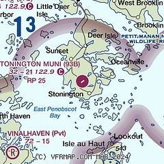
| Sectional chart |
|---|
|
| Airport distance calculator |
|---|
|
|
| Sunrise and sunset |
|---|
|
Times for 23-Apr-2026
| | Local
(UTC-4) | | Zulu
(UTC) |
|---|
| Morning civil twilight | | 05:08 | | 09:08 |
| Sunrise | | 05:39 | | 09:39 |
| Sunset | | 19:27 | | 23:27 |
| Evening civil twilight | | 19:58 | | 23:58 |
|
| Current date and time |
|---|
| Zulu (UTC) | 24-Apr-2026 00:31:25 |
|---|
| Local (UTC-4) | 23-Apr-2026 20:31:25 |
|---|
|
| METAR |
|---|
KRKD
19nm W | 232356Z AUTO 32007KT 290V360 10SM SCT060 07/M03 A2985 RMK AO2 SLP107 6//// T00671028 10106 20067 53013
|
KBHB
21nm NE | 232356Z AUTO 33007KT 10SM OVC036 06/00 A2983 RMK AO2 SLP104 60001 T00560000 10078 20056 53013 $
|
|
| TAF |
|---|
KRKD
19nm W | 231724Z 2318/2418 33010G18KT P6SM BKN040 BKN060 FM240000 32006KT P6SM SCT040 SCT080 FM241400 34009G16KT P6SM BKN040 BKN060
|
KBHB
21nm NE | 232204Z 2322/2418 35010KT P6SM VCSH SCT025 OVC035 FM232300 35004KT P6SM BKN025 FM240600 35004KT P6SM SCT050 FM241200 34006KT P6SM BKN040
|
|
| NOTAMs |
|---|
NOTAMs are issued by the DoD/FAA and will open in a separate window not controlled by AirNav.
|
|

